- My Forums
- Tiger Rant
- LSU Recruiting
- SEC Rant
- Saints Talk
- Pelicans Talk
- More Sports Board
- Fantasy Sports
- Golf Board
- Soccer Board
- O-T Lounge
- Tech Board
- Home/Garden Board
- Outdoor Board
- Health/Fitness Board
- Movie/TV Board
- Book Board
- Music Board
- Political Talk
- Money Talk
- Fark Board
- Gaming Board
- Travel Board
- Food/Drink Board
- Ticket Exchange
- TD Help Board
Customize My Forums- View All Forums
- Show Left Links
- Topic Sort Options
- Trending Topics
- Recent Topics
- Active Topics
Started By
Message
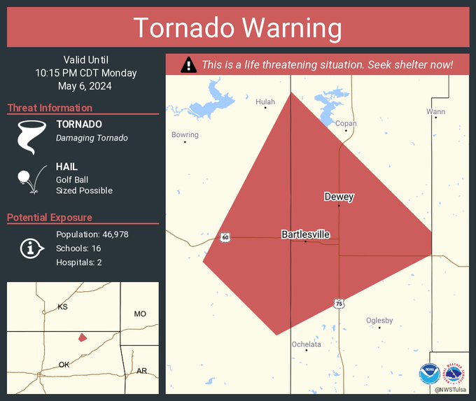
re: 5/6 Oklahoma/Kansas severe weather - High Risk- PDS Tor Watch
Posted on 5/6/24 at 9:55 pm to LegendInMyMind
Posted on 5/6/24 at 9:55 pm to LegendInMyMind
About 5 minutes from Bartlesville
 0
0

Posted on 5/6/24 at 9:55 pm to Roll Tide Ravens
Phillips 66 Research Center and the Airport are on west side of the city near the possible path.
Posted on 5/6/24 at 9:55 pm to Roll Tide Ravens
quote:
hopefully the main line will weaken it before it gets there.
Last few radar frames are looking that way
Posted on 5/6/24 at 9:55 pm to LegendInMyMind
Think the front can’t over take it and weaken it?
Posted on 5/6/24 at 9:56 pm to SWLA92
They saying a 1.5 mile wide tornado on ground heading toward Bartlesville right now. The hook echo on radar is pretty clear. Trying to find a streamer near it. Reed is west of OKC so he's far away.
Posted on 5/6/24 at 9:56 pm to LegendInMyMind
Looks like it is going to hit Bartlesville. CC Drop is still huge
Posted on 5/6/24 at 9:57 pm to AUstar
Copic has stayed back in Barnsdall to help with search and rescue

Posted on 5/6/24 at 9:57 pm to SWLA92
Severe Weather Statement
National Weather Service Tulsa OK
946 PM CDT Mon May 6 2024
OKC113-147-070315-
/O.CON.KTSA.TO.W.0047.000000T0000Z-240507T0315Z/
Osage OK-Washington OK-
946 PM CDT Mon May 6 2024
...TORNADO EMERGENCY FOR RURAL FAR EASTERN OSAGE COUNTY...
...A TORNADO WARNING REMAINS IN EFFECT UNTIL 1015 PM CDT FOR EAST
CENTRAL OSAGE AND NORTHERN WASHINGTON COUNTIES...
At 946 PM CDT, a confirmed large and destructive tornado was located
4 miles northeast of Barnsdall, moving northeast at 50 mph.
TORNADO EMERGENCY for Rural Far Eastern Osage county. This is a
PARTICULARLY DANGEROUS SITUATION. TAKE COVER NOW!
HAZARD...Deadly tornado.
SOURCE...Radar confirmed tornado.
IMPACT...You are in a life-threatening situation. Flying debris may
be deadly to those caught without shelter. Mobile homes
will be destroyed. Considerable damage to homes,
businesses, and vehicles is likely and complete destruction
is possible.
Locations in or near the path include...
Bartlesville... Dewey...
Barnsdall... Okesa...
Bartlesville Municipal Airport... Tallant...
PRECAUTIONARY/PREPAREDNESS ACTIONS...
To repeat, a large, extremely dangerous, and potentially deadly
tornado is on the ground. To protect your life, TAKE COVER NOW! Move
to an interior room on the lowest floor of a sturdy building. Avoid
windows. If in a mobile home, a vehicle or outdoors, move to the
closest substantial shelter and protect yourself from flying debris.
&&
LAT...LON 3676 9581 3673 9581 3649 9617 3655 9626
3695 9600
TIME...MOT...LOC 0246Z 210DEG 44KT 3662 9612
TORNADO...OBSERVED
TORNADO DAMAGE THREAT...CATASTROPHIC
MAX HAIL SIZE...1.75 IN
$$

Posted on 5/6/24 at 9:59 pm to Steve Rogers
Bartlesville has 37,000 population

Posted on 5/6/24 at 9:59 pm to AUstar
Continued

Posted on 5/6/24 at 9:59 pm to SWLA92
Looks like it’s on Bartlesville now
Posted on 5/6/24 at 9:59 pm to Pisco
4 miles south of airport now. heading NE at 50 into western part of city.
quote:
Severe Weather Statement
National Weather Service Tulsa OK
957 PM CDT Mon May 6 2024
OKC113-147-070315-
/O.CON.KTSA.TO.W.0047.000000T0000Z-240507T0315Z/
Osage OK-Washington OK-
957 PM CDT Mon May 6 2024
...A TORNADO WARNING REMAINS IN EFFECT UNTIL 1015 PM CDT FOR EAST
CENTRAL OSAGE AND NORTHERN WASHINGTON COUNTIES...
At 956 PM CDT, a confirmed large and extremely dangerous tornado was
located 4 miles south of Bartlesville Municipal Airport, moving
northeast at 50 mph.
This is a PARTICULARLY DANGEROUS SITUATION. TAKE COVER NOW!
HAZARD...Damaging tornado.
SOURCE...Radar confirmed tornado.
IMPACT...You are in a life-threatening situation. Flying debris may
be deadly to those caught without shelter. Mobile homes
will be destroyed. Considerable damage to homes,
businesses, and vehicles is likely and complete destruction
is possible.
Locations in or near the path include...
Bartlesville... Dewey...
Bartlesville Municipal Airport...
Posted on 5/6/24 at 9:59 pm to AUstar
Radar indicated 90mph winds entering Bartlesville looking like the front won’t get there in time to help

Posted on 5/6/24 at 9:59 pm to LegendInMyMind
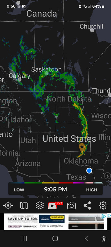
Looks how far that line goes. Clear up to central Canada.

Posted on 5/6/24 at 10:01 pm to Bobby OG Johnson
That’s pretty much a direct hit on radar? Yikes
Posted on 5/6/24 at 10:01 pm to Pisco
quote:
TORNADO EMERGENCY FOR RURAL FAR EASTERN OSAGE COUNTY...
That's the NWS way of saying "Oh shite it's happening, you about to die if you aren't underground."
Posted on 5/6/24 at 10:01 pm to LegendInMyMind
Looks like the front has propelled it
Posted on 5/6/24 at 10:01 pm to LegendInMyMind
The gust front acted similar to an RFD surge and boosted that rotation as it merged with the line. Dammit.

Posted on 5/6/24 at 10:02 pm to Roll Tide Ravens
Look at how the debris ball lit up as the tornado went through Barnsdall.


 Page 22 of 30

Popular
Back to top