- My Forums
- Tiger Rant
- LSU Recruiting
- SEC Rant
- Saints Talk
- Pelicans Talk
- More Sports Board
- Fantasy Sports
- Golf Board
- Soccer Board
- O-T Lounge
- Tech Board
- Home/Garden Board
- Outdoor Board
- Health/Fitness Board
- Movie/TV Board
- Book Board
- Music Board
- Political Talk
- Money Talk
- Fark Board
- Gaming Board
- Travel Board
- Food/Drink Board
- Ticket Exchange
- TD Help Board
Customize My Forums- View All Forums
- Show Left Links
- Topic Sort Options
- Trending Topics
- Recent Topics
- Active Topics
Started By
Message
 2
2

Posted on 6/14/23 at 1:07 pm to LegendInMyMind
I hope Texarkana storm goes south of me it’s moving SE not E right?

Posted on 6/14/23 at 1:08 pm to LegendInMyMind

Posted on 6/14/23 at 1:09 pm to LegendInMyMind
[quote]I'm watching, baw. Just didn't start the thread.[/quote
Yea you left me to do it and absorb all the downvotes
This must be how Jesus felt up on that cross dying for everyone’s sins
Yea you left me to do it and absorb all the downvotes
This must be how Jesus felt up on that cross dying for everyone’s sins
Posted on 6/14/23 at 1:11 pm to deltaland
quote:
I hope Texarkana storm goes south of me it’s moving SE not E right?
I don't think it will be a problem for you. It is headed more towards Monroe.
Posted on 6/14/23 at 1:17 pm to Bobby OG Johnson
Spinny & bubbly out here

Posted on 6/14/23 at 1:19 pm to Bobby OG Johnson
We also may have a der...like storm brewing that is stretching from Cullman, AL down to Jasper.
Posted on 6/14/23 at 1:20 pm to deltaland
quote:
Legend, Duke and RDS must be vacationing in 30A this week
I have a 5 day old baw.
Posted on 6/14/23 at 1:21 pm to LegendInMyMind
quote:
We also may have a der...like storm brewing that is stretching from Cullman, AL down to Jasper.
Y'all be safe
Posted on 6/14/23 at 1:21 pm to Bobby OG Johnson
That'll be south of me by a good bit, but that storm has caused power outages already in Winston county.
Posted on 6/14/23 at 1:22 pm to Bobby OG Johnson

I'm impressed with the storms that are meeting significant severe criteria for both hail and wind.
From my observations, it seems super rare for storms with very large hail to also have hurricane force wind gusts.
Posted on 6/14/23 at 1:23 pm to Downburst

Posted on 6/14/23 at 1:25 pm to Downburst
quote:
I'm impressed with the storms that are meeting significant severe criteria for both hail and wind.
From my observations, it seems super rare for storms with very large hail to also have hurricane force wind gusts.
Got those westerlies screaming and shear is on the lower end. Lots of CAPE, especially 3CAPE to get the updrafts growing. All that equals big hail and wind.

Posted on 6/14/23 at 1:25 pm to LegendInMyMind
Weird to have this type of severe risk in mid June. This is more akin to something you’d see in March or April.
Posted on 6/14/23 at 1:26 pm to LegendInMyMind
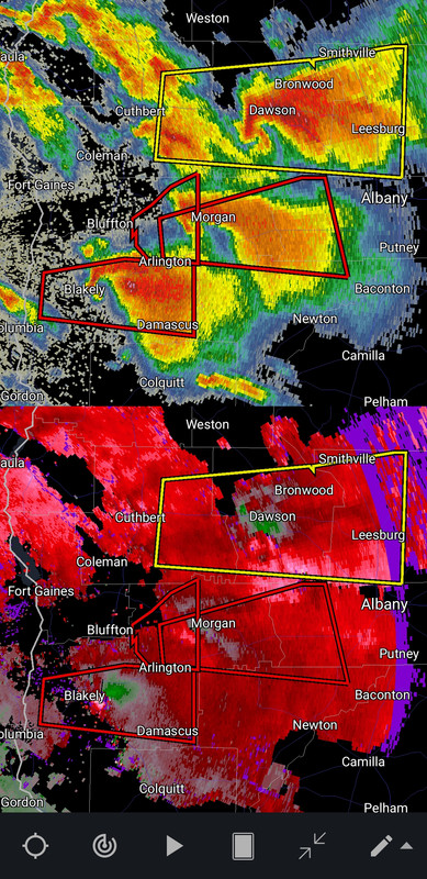
A TORNADO WARNING REMAINS IN EFFECT UNTIL 245 PM EDT FOR NORTHEASTERN EARLY COUNTY...
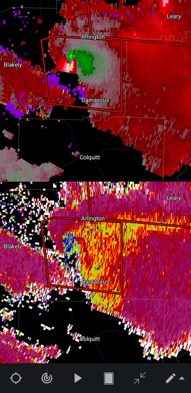
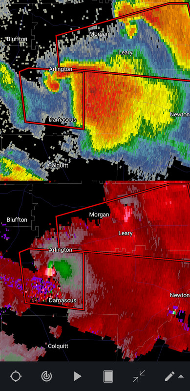
At 221 PM EDT, a confirmed large and extremely dangerous tornado was located near Arlington, or 9 miles east of Blakely, moving east at 35 mph.
This is a PARTICULARLY DANGEROUS SITUATION. TAKE COVER NOW!
HAZARD...Damaging tornado.
SOURCE...Radar confirmed tornado.
IMPACT...You are in a life-threatening situation. Flying debris may be deadly to those caught without shelter. Mobile homes will be destroyed. Considerable damage to homes, businesses, and vehicles is likely and complete destruction is possible.
The tornado will be near... Arlington around 230 PM EDT.
Other locations impacted by this tornadic thunderstorm include Douglasville, Old Damascus, Damascus and Rowena.
This post was edited on 6/14/23 at 1:28 pm
Posted on 6/14/23 at 1:28 pm to Paul Allen
quote:
Weird to have this type of severe risk in mid June. This is more akin to something you’d see in March or April.
This was posted on the first page dumbass
Posted on 6/14/23 at 1:30 pm to Duke
quote:
have a 5 day old baw.
Didn't yall have a kid last hurricane season??
Better start hoarding the milk

 Page 2 of 6

Popular
Back to top