- My Forums
- Tiger Rant
- LSU Recruiting
- SEC Rant
- Saints Talk
- Pelicans Talk
- More Sports Board
- Fantasy Sports
- Golf Board
- Soccer Board
- O-T Lounge
- Tech Board
- Home/Garden Board
- Outdoor Board
- Health/Fitness Board
- Movie/TV Board
- Book Board
- Music Board
- Political Talk
- Money Talk
- Fark Board
- Gaming Board
- Travel Board
- Food/Drink Board
- Ticket Exchange
- TD Help Board
Customize My Forums- View All Forums
- Show Left Links
- Topic Sort Options
- Trending Topics
- Recent Topics
- Active Topics
Started By
Message

No severe weather thread today?
Posted on 6/14/23 at 12:29 pm
Posted on 6/14/23 at 12:29 pm
Moderate risk from Louisiana to Georgia
Hail, damaging winds and tornadoes possible throughout this afternoon and tonight in several different waves of supercells. Odd June setup for sure with storms moving east to southeast. Already a few discrete cells in Georgia tornado warned

ArkLaTex to GA through tonight...
The unusually strong flow pattern continues from the southern Plains
eastward to the Southeast, with 50+ kt midlevel flow across the
corridor, coincident with steep midlevel lapse rates and strong
buoyancy. Embedded speed maxima will move generally eastward
through this corridor, around the southern periphery of the midlevel
closed low over the lower Great Lakes. The primary severe threat
will continue through the afternoon and into tonight from the
ArkLaTex across MS/AL into southern GA.
Multiple clusters of severe storms are ongoing, including both
supercells and line segments. The cluster in northern MS will
likely persist through the afternoon while moving east-southeastward
across central AL, where additional supercell development is
expected within the warm sector ahead of the cluster. The
environment of large buoyancy (MLCAPE 3000-4000 K/kg) and effective
bulk shear in excess of 60 kt is quite unusual for mid June into the
I-20 corridor, and this will support an unusually high threat for
severe storms (including significant severe events). Supercells
will be capable of producing isolated very large hail to near 3
inches in diameter with the supercells forming in northeast TX, and
with supercells farther east into AL. A complex storm evolution is
expected from MS across AL into GA along the buoyancy gradient, as
the ongoing clusters and new storms interact and potentially support
upscale growth into larger clusters.
Swaths of wind damage, some up to 80 mph, can be expected with the
MS/AL clusters this afternoon and into GA along the residual outflow
boundary. This boundary will locally enhance low-level shear, with
the potential for a few tornadoes (a couple of which could be
strong), from southwest GA into southeast/central AL with both the
isolated supercells and with embedded circulations in any larger
clusters. Another cluster could evolve from the northeast TX
supercells, and this convection will have a corridor of strong
instability to support its maintenance across northern LA into
central MS and eventually AL later this afternoon into early
tonight. The initial supercells could produce very large hail,
while upscale growth will favor swaths of damaging winds (some
significant), as well as a few tornadoes.
...Central TX this afternoon/evening...
Strong-extreme buoyancy is expected again across central TX, but
forcing for ascent will be weak. If sufficient heating/mixing can
occur, an isolated storm may form this afternoon along the surface
front into central TX. The environment conditionally favors
splitting supercells with very large hail, though storm
formation/coverage is uncertain.
...Northern Mid-Atlantic/southern New England this afternoon...
Pockets of surface heating will drive weak buoyancy to the east of
the low across southern New England, where isolated strong-severe
storms may occur (see MD #1037 for additional information).
..Thompson/Squitieri.. 06/14/2023
Hail, damaging winds and tornadoes possible throughout this afternoon and tonight in several different waves of supercells. Odd June setup for sure with storms moving east to southeast. Already a few discrete cells in Georgia tornado warned
ArkLaTex to GA through tonight...
The unusually strong flow pattern continues from the southern Plains
eastward to the Southeast, with 50+ kt midlevel flow across the
corridor, coincident with steep midlevel lapse rates and strong
buoyancy. Embedded speed maxima will move generally eastward
through this corridor, around the southern periphery of the midlevel
closed low over the lower Great Lakes. The primary severe threat
will continue through the afternoon and into tonight from the
ArkLaTex across MS/AL into southern GA.
Multiple clusters of severe storms are ongoing, including both
supercells and line segments. The cluster in northern MS will
likely persist through the afternoon while moving east-southeastward
across central AL, where additional supercell development is
expected within the warm sector ahead of the cluster. The
environment of large buoyancy (MLCAPE 3000-4000 K/kg) and effective
bulk shear in excess of 60 kt is quite unusual for mid June into the
I-20 corridor, and this will support an unusually high threat for
severe storms (including significant severe events). Supercells
will be capable of producing isolated very large hail to near 3
inches in diameter with the supercells forming in northeast TX, and
with supercells farther east into AL. A complex storm evolution is
expected from MS across AL into GA along the buoyancy gradient, as
the ongoing clusters and new storms interact and potentially support
upscale growth into larger clusters.
Swaths of wind damage, some up to 80 mph, can be expected with the
MS/AL clusters this afternoon and into GA along the residual outflow
boundary. This boundary will locally enhance low-level shear, with
the potential for a few tornadoes (a couple of which could be
strong), from southwest GA into southeast/central AL with both the
isolated supercells and with embedded circulations in any larger
clusters. Another cluster could evolve from the northeast TX
supercells, and this convection will have a corridor of strong
instability to support its maintenance across northern LA into
central MS and eventually AL later this afternoon into early
tonight. The initial supercells could produce very large hail,
while upscale growth will favor swaths of damaging winds (some
significant), as well as a few tornadoes.
...Central TX this afternoon/evening...
Strong-extreme buoyancy is expected again across central TX, but
forcing for ascent will be weak. If sufficient heating/mixing can
occur, an isolated storm may form this afternoon along the surface
front into central TX. The environment conditionally favors
splitting supercells with very large hail, though storm
formation/coverage is uncertain.
...Northern Mid-Atlantic/southern New England this afternoon...
Pockets of surface heating will drive weak buoyancy to the east of
the low across southern New England, where isolated strong-severe
storms may occur (see MD #1037 for additional information).
..Thompson/Squitieri.. 06/14/2023
 8
8


Posted on 6/14/23 at 12:30 pm to deltaland
My yard is a desert currently. I could use some severe weather!
Posted on 6/14/23 at 12:34 pm to deltaland
I came here looking for it as well
Posted on 6/14/23 at 12:35 pm to deltaland
shite. LSU’s game on Saturday was just delayed indefinitely in response to this thread.
Posted on 6/14/23 at 12:41 pm to SidewalkTiger
Legend, Duke and RDS must be vacationing in 30A this week
Posted on 6/14/23 at 12:41 pm to deltaland
no need, no baseball game at the Box today

Posted on 6/14/23 at 12:42 pm to deltaland
Gonna be too hot to rain today in Baton Rouge.
Posted on 6/14/23 at 12:46 pm to deltaland
quote:
Legend, Duke and RDS must be vacationing in 30A this week
I'm watching, baw. Just didn't start the thread. Now, Duke......I bet he's drinking gin relaxing on a beach somewhere as I type this.
ETA: The storm between Shreveport and Texarkana has a chance to be a big problem down the line. I won't say the "D-word", but the SPC did.
This post was edited on 6/14/23 at 12:49 pm

Posted on 6/14/23 at 12:51 pm to deltaland
This is a remarkable and very abnormal setup for June. The winds aloft/shear are more like what we would see in March or April. Typically the southeast doesn’t see tornadoes in June unless they’re associated with a land falling tropical system. Hail also looks to be a major issue.
This post was edited on 6/14/23 at 12:53 pm
Posted on 6/14/23 at 12:52 pm to LegendInMyMind
She's cranking too. Just picked up a tor warning to boot.

Posted on 6/14/23 at 12:53 pm to LegendInMyMind
quote:
I won't say the "D-word", but the SPC did.
Aw shite, demogorgons.
Posted on 6/14/23 at 12:54 pm to Roll Tide Ravens
quote:
This is a remarkable and very abnormal setup for June. The winds aloft/shear are more like what we would see in March or April. Typically the southeast doesn’t see tornadoes in June unless they’re associated with a land falling tropical system. Hail also looks to be a major
The most remarkable aspect may be the hail threat. Yesterday's hail prob outlook was huge:
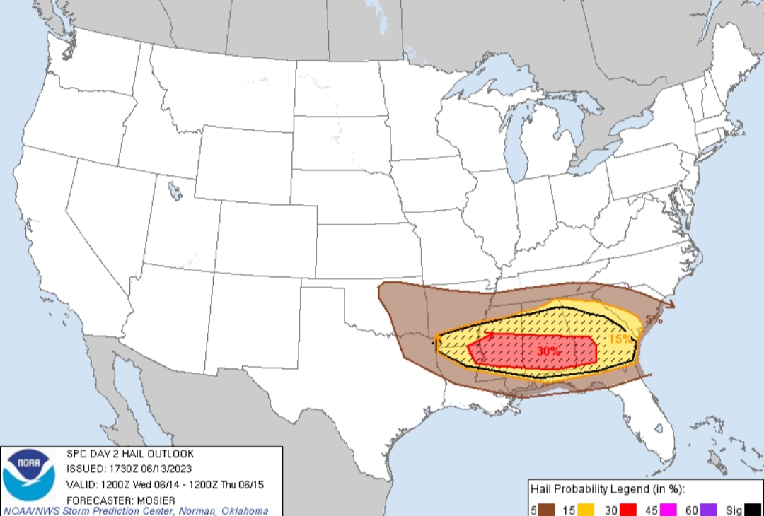
The Day 1 was even more impressive.
This post was edited on 6/14/23 at 12:57 pm
Posted on 6/14/23 at 12:56 pm to LegendInMyMind
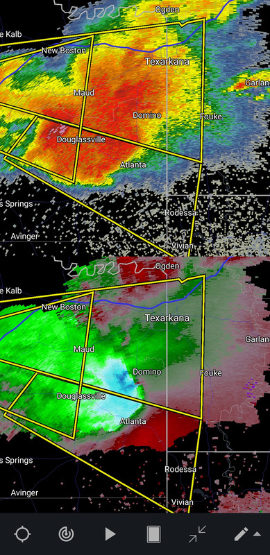
Tornado confirmed in that Texarkana storm.
Posted on 6/14/23 at 12:57 pm to HogX
quote:
demogorgons
They're the fricking worst!
Posted on 6/14/23 at 12:57 pm to 777Tiger
Nasty storm near Texarkana

Posted on 6/14/23 at 12:58 pm to deltaland
Just popped a tornado warning for that storm
Posted on 6/14/23 at 12:59 pm to LegendInMyMind
Looks like I picked the wrong week to quit drinking
Posted on 6/14/23 at 1:04 pm to deltaland
Big hailer headed your way in a bit for anyone in the Aliceville/Moundville/South of Tuscaloosa area. Now's a good time to find some cover for your vehicles.

Posted on 6/14/23 at 1:05 pm to deltaland
My maters were just getting ready to pluck, and now all this rain is going to make them split.
Posted on 6/14/23 at 1:05 pm to deltaland
Pretty good cell building near lake village

 Page 1 of 6

Popular
Back to top