- My Forums
- Tiger Rant
- LSU Recruiting
- SEC Rant
- Saints Talk
- Pelicans Talk
- More Sports Board
- Fantasy Sports
- Golf Board
- Soccer Board
- O-T Lounge
- Tech Board
- Home/Garden Board
- Outdoor Board
- Health/Fitness Board
- Movie/TV Board
- Book Board
- Music Board
- Political Talk
- Money Talk
- Fark Board
- Gaming Board
- Travel Board
- Food/Drink Board
- Ticket Exchange
- TD Help Board
Customize My Forums- View All Forums
- Show Left Links
- Topic Sort Options
- Trending Topics
- Recent Topics
- Active Topics
Started By
Message
re: No severe weather thread today?
Posted on 6/14/23 at 3:17 pm to Bobby OG Johnson

Posted on 6/14/23 at 3:17 pm to Bobby OG Johnson
 0
0

Posted on 6/14/23 at 3:18 pm to Mstate
quote:
I’m supposed to be driving from Birmingham to orange beach this afternoon/night. Should I just hold off till the morning?
If it isn't a huge inconvenience that may not be the worst idea. Weather is gonna suck, and it is going the same direction you're going. Or, you may be able to work it where you ride behind the storms the entire way.
Posted on 6/14/23 at 3:19 pm to Bobby OG Johnson
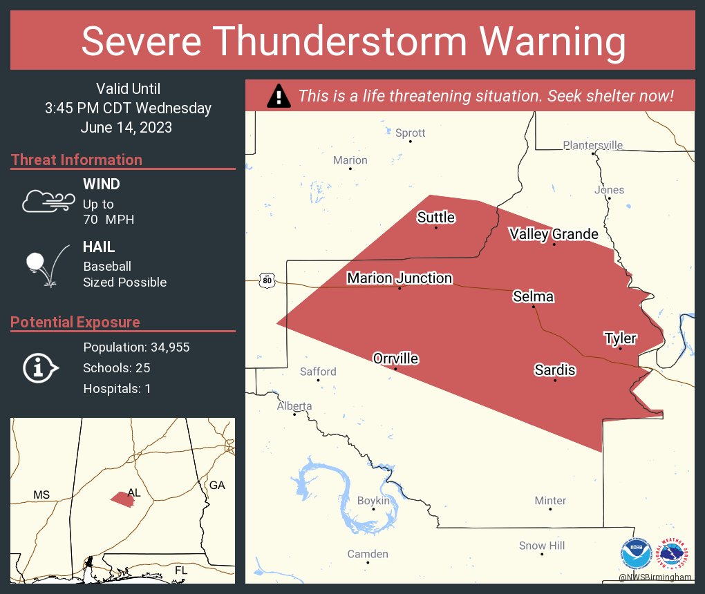
That north Louisiana storm is back to meaning bidness. Nasty, nasty. This will be going just south of Monroe near Columbia and Clarks. This storm is warned for softball sized hail now, along with 70mph winds.
And the storm at Kosciusko is probably our biggest wind right now.
And the storm at Kosciusko is probably our biggest wind right now.
This post was edited on 6/14/23 at 3:28 pm
Posted on 6/14/23 at 3:33 pm to LegendInMyMind
I feel like they’re way looser these days on the parameters for a PDS than they used to be
Posted on 6/14/23 at 3:34 pm to LegendInMyMind

Posted on 6/14/23 at 3:38 pm to deltaland
quote:
I feel like they’re way looser these days on the parameters for a PDS than they used to be
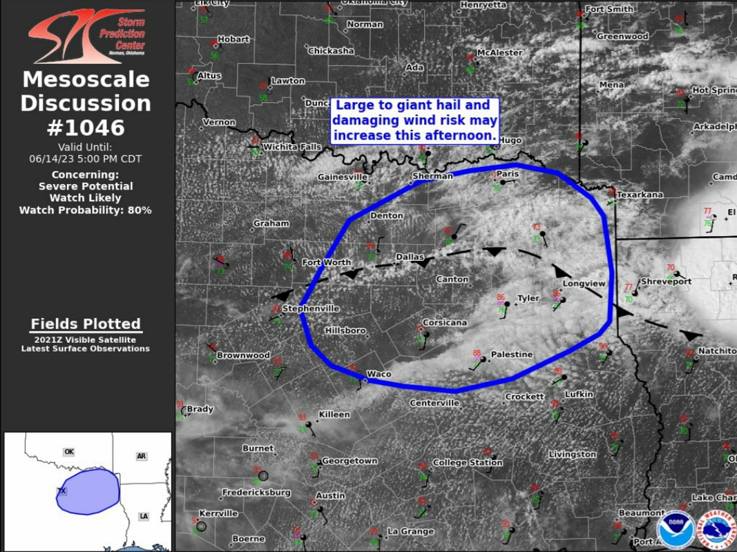
Different ball game when you start talking PDS severe thunderstorms and potential derechos. Add in a sort of hybrid setup with a broken line with embedded 80mph winds and very large hail, and they're going to issue them.
This post was edited on 6/14/23 at 3:39 pm
Posted on 6/14/23 at 3:40 pm to LegendInMyMind
Low Res Group energy gif

Posted on 6/14/23 at 3:43 pm to Bobby OG Johnson
Outflow boundaries, gravity waves, cell mergers, and all the lightning. Good find, Bobby!
Posted on 6/14/23 at 3:43 pm to Bobby OG Johnson
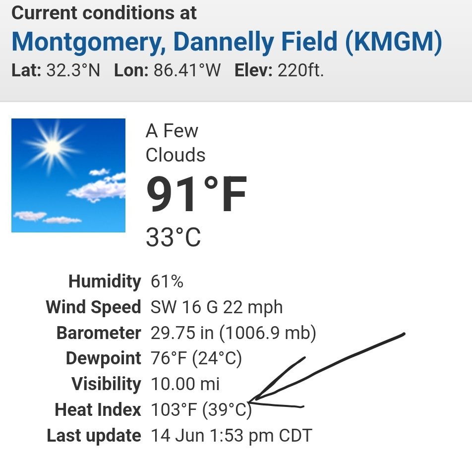
My jeep has no AC. I have an inverter that works my table fan in my passenger seat which does a great job. The inverter over-heated. Now I'm really hot. Stupid heat
Posted on 6/14/23 at 3:44 pm to deltaland
quote:
I feel like they’re way looser these days on the parameters for a PDS than they used to be
Well, given the storm environment and structure already seen today I would say the PDS wording is spot on...
Current MLCAPE


EHI
The Energy Helicity Index (EHI) is a number which represents the combination of instability and storm relative helicity. Our calculation uses mixed layer CAPE (surface to 3000ft average parcel) and 0-3 km storm relative helicity. Values greater than 2 or 3 have been correlated to cyclonic supercells with increased tornadic potential. Negative values are indicative of an environment favorable for anti-cyclonic (left moving) supercells, but tornadoes associated with anti-cyclonic supercells are extremely rare.

Posted on 6/14/23 at 3:46 pm to Zapps4Life
quote:
Current MLCAPE
Modeled soundings verified on CAPE this time. If anything, they undershot it a bit.
Posted on 6/14/23 at 3:50 pm to LegendInMyMind

Downdraft CAPE, or DCAPE, is the maximum energy available to a descending parcel of air. The higher the value of DCAPE, the stronger the downdraft potential. Values of DCAPE greater than 800 joules/kilogram (J/kg) are decent values, while values exceeding 1200 J/kg are very high.
Posted on 6/14/23 at 3:51 pm to The Ramp
quote:
My jeep has no AC. I have an inverter that works my table fan in my passenger seat which does a great job. The inverter over-heated. Now I'm really hot. Stupid heat
quote:
The Ramp

Posted on 6/14/23 at 3:54 pm to LegendInMyMind
I was driving this morning at 5 AM around Birmingham/ Tuscaloosa and it was some of the hardest rain I've driven through. Pretty sure there may have been some small hail, but that may have been just big drops of rain bouncing off the asphalt. I could only drive about 35 or so. Thankfully, there was no other traffic, especially 18 wheelers at the time.
Posted on 6/14/23 at 4:00 pm to Bobby OG Johnson

Posted on 6/14/23 at 4:07 pm to Bobby OG Johnson
That storm has cleared Monroe. Still warned for softballs. That's been a hell of a storm.
Posted on 6/14/23 at 4:08 pm to deltaland
So what
Posted on 6/14/23 at 4:10 pm to Fred innocent
Look at Fred. Fred's a badass. Fred wants you to know he's a badass. Fred gets his jollies from being a badass on a message board.
Posted on 6/14/23 at 4:17 pm to LegendInMyMind
Am I clear for the rest of the night or is there another round going to build up?

 Page 4 of 6

Popular
Back to top