- My Forums
- Tiger Rant
- LSU Recruiting
- SEC Rant
- Saints Talk
- Pelicans Talk
- More Sports Board
- Fantasy Sports
- Golf Board
- Soccer Board
- O-T Lounge
- Tech Board
- Home/Garden Board
- Outdoor Board
- Health/Fitness Board
- Movie/TV Board
- Book Board
- Music Board
- Political Talk
- Money Talk
- Fark Board
- Gaming Board
- Travel Board
- Food/Drink Board
- Ticket Exchange
- TD Help Board
Customize My Forums- View All Forums
- Show Left Links
- Topic Sort Options
- Trending Topics
- Recent Topics
- Active Topics
Started By
Message
 0
0

Posted on 9/29/22 at 10:37 pm to CobraCommander83

Was talking extratropical transition earlier today with someone.
It's starting.
That dry slot on the SE side is a good sign, as well as the front dragging to it's S. It's still got convection at the center, so the core is working a warm-core process. This is how it eventually ends for a hurricane but a slow moving version for Ian it looks like.
Posted on 9/29/22 at 10:39 pm to UncleFestersLegs
Local stations are saying landfall between 12-1400 and more likely out of the area around 2100. I know with the tides today, Garden City was already flooding a little bit. Good news is that majority of the rivers are low and not expected to flood like they did during 2015, Matthew, or Florence
Posted on 9/29/22 at 10:45 pm to Duke
quote:
Was talking extratropical transition earlier today with someone. It's starting. That dry slot on the SE side is a good sign, as well as the front dragging to it's S. It's still got convection at the center, so the core is working a warm-core process. This is how it eventually ends for a hurricane but a slow moving version for Ian it looks like.
One of our local weatherman was talking about that earlier this evening. Sounded like this thing will fall apart fairly quick once it gets back on land.
Posted on 9/29/22 at 10:45 pm to Duke
quote:I'm hoping all that is good news
That dry slot on the SE side is a good sign, as well as the front dragging to it's S. It's still got convection at the center, so the core is working a warm-core process. This is how it eventually ends for a hurricane but a slow moving version for Ian it looks like.
This post was edited on 9/29/22 at 10:46 pm
Posted on 9/29/22 at 10:49 pm to UncleFestersLegs
It is.
This is the beginning of the end.
Theres still a moist bubble near the core and its firing storms around it. So its tropical still and producing all the threats of a big Cat 1 hurricane (the extra surge version).
It'll transition ET fast on land, spreading out the rain and the wind (but reducing it).
Posted on 9/29/22 at 11:05 pm to UncleFestersLegs
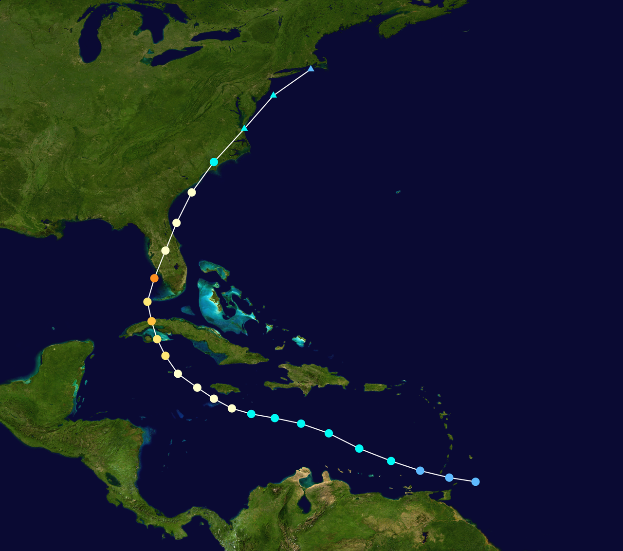
TWC just said that Ian hit the same spot as Charley and could make the second landfall in South Carolina close to where Charley made landfall.
Posted on 9/29/22 at 11:10 pm to lsuman25
quote:
11:15 PM EDT Thu Sep 29
Location: 30.2°N 79.3°W
Moving: NNE at 10 mph
Min pressure: 984 mb
Max sustained: 85 mph
Pressure dropped 4mb and the winds went up 5mph since recon got in the storm.
Posted on 9/29/22 at 11:28 pm to LegendInMyMind
quote:damn thing needs to get to 15-20mph and GTFO
Moving: NNE at 10 mph

Posted on 9/29/22 at 11:31 pm to CobraCommander83
quote:
TWC just said that Ian hit the same spot as Charley and could make the second landfall in South Carolina close to where Charley made landfall.
Which was only a glancing blow. Just like for Florida Ian will have a much bigger impact in South and North Carolina than Charley had.
Ian slamming in to shore perpendicularly will increase impacts considerably.

Posted on 9/29/22 at 11:41 pm to The Boat
Damn wind field over 4 states.. crazy
This post was edited on 9/29/22 at 11:42 pm
Posted on 9/29/22 at 11:43 pm to UncleFestersLegs
GA isn’t a state. They are a commie territory.

Posted on 9/30/22 at 12:58 am to PsychTiger
One of our properties in Venice got hit bad. Pool cage destroyed, roof torn apart, flooding in the ceiling, etc. What's the best way to document this for insurance? Any other tips? 
Posted on 9/30/22 at 1:38 am to The Boat
It was windy at noon in Raleigh at noon yesterday, almost 15 hrs ago. The hurricane was 500 miles away as well.

Posted on 9/30/22 at 1:53 am to TheOcean
Photos and videos of your home/property/vehicles. Helps if you took some before as well.
This post was edited on 9/30/22 at 1:54 am
Posted on 9/30/22 at 2:02 am to ColoradoAg03
quote:
Photos and videos of your home/property/vehicles.
Can never have enough.
Photograph/list every personal item thrown out also. Build a spreadsheet for insurance.
Photograph inside of refrigerator/freezer before emptying.
Keep ice cold Gatorade and beer for linemen. Make friends with them. They alone hold the answer to the holy grail of questions: “When will my balls get A/C again?”
Gas receipts.

Posted on 9/30/22 at 2:20 am to AmosMosesAndTwins
Also- FEMA will typically reimburse you for the purchase of a generator and chainsaw for clean up
Posted on 9/30/22 at 2:52 am to AmosMosesAndTwins
We just lost power (in Sebring). We’ve had it the whole time during the hurricane (except for it going on and off several times during the storm). Most of our county is without electricity. Anyone know why we would lose it now (it’s been about 24 hours since the storm passed)?
Posted on 9/30/22 at 3:01 am to shreveport_gator
Probably had to shut it down to work on other lines within your grid.

 Page 450 of 465

Popular
Back to top