- My Forums
- Tiger Rant
- LSU Recruiting
- SEC Rant
- Saints Talk
- Pelicans Talk
- More Sports Board
- Coaching Changes
- Fantasy Sports
- Golf Board
- Soccer Board
- O-T Lounge
- Tech Board
- Home/Garden Board
- Outdoor Board
- Health/Fitness Board
- Movie/TV Board
- Book Board
- Music Board
- Political Talk
- Money Talk
- Fark Board
- Gaming Board
- Travel Board
- Food/Drink Board
- Ticket Exchange
- TD Help Board
Customize My Forums- View All Forums
- Show Left Links
- Topic Sort Options
- Trending Topics
- Recent Topics
- Active Topics
Started By
Message

New Year’s Day Severe Weather Thread - Enhanced Risk in AL, TN, MS, AR
Posted on 12/31/21 at 6:45 am

Posted on 12/31/21 at 6:45 am
New Year’s Day severe weather outlook:

NYD tornado probabilities:

NYD tornado probabilities:
This post was edited on 1/1/22 at 7:24 pm
 16
16

Posted on 12/31/21 at 6:49 am to Roll Tide Ravens
Thanks for starting this thread. I was about to.
I'm travelling tomorrow, so will need to keep an eye on this.
Also, to emphasize the severity potential of this is the mentioning of snow flurries on the back end of all this on Sunday.
I'm travelling tomorrow, so will need to keep an eye on this.
Also, to emphasize the severity potential of this is the mentioning of snow flurries on the back end of all this on Sunday.
Posted on 12/31/21 at 6:54 am to Roll Tide Ravens
Close to the same set up as the early December system. Little less on some of the dynamics but it’s going to be a bumpy afternoon/night in the mid south.
Posted on 12/31/21 at 8:09 am to beebefootballfan
Hard to imagine all this warm weather not causing some bad chit somewhere
Posted on 12/31/21 at 11:16 am to East Coast Band
Pretty big cold front behind this stuff. Who's getting snow?
Posted on 12/31/21 at 11:26 am to Roll Tide Ravens
You folks in Central AL shouldn't sleep on any storms that develop this afternoon. They'll have a chance to over perform well outside of the Slight Risk area.
ETA: And Reed just put out an update from Hoover saying basically the same thing.
ETA:
This post was edited on 12/31/21 at 11:29 am
Posted on 12/31/21 at 11:29 am to lsufb1912
quote:
Pretty big cold front behind this stuff. Who's getting snow?
It will all fall directly on/in the Mississippi River because tBoat got rowdy and spooked the snow.
Posted on 12/31/21 at 11:33 am to LegendInMyMind
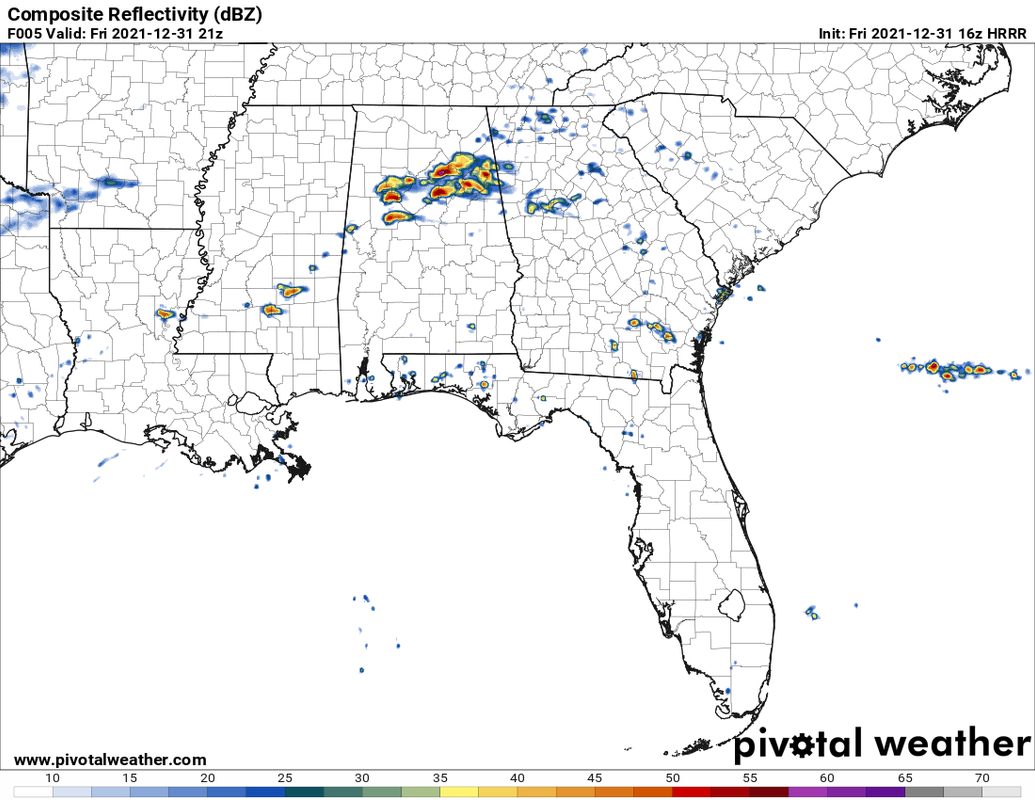
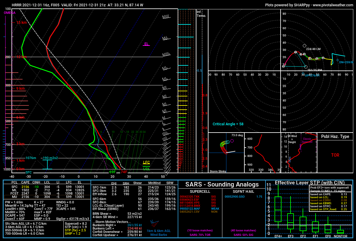
From the 16z HRRR and a sounding to go with it:
Posted on 12/31/21 at 11:36 am to LegendInMyMind
quote:
Central AL shouldn't sleep on any storms
shite. We're in Pelham and supposed to go to a birthday party this afternoon on lay lake. I will be watching.

Posted on 12/31/21 at 11:39 am to Roll Tide Ravens
They really don't like the Memphis area. I wish they would focus their weather beam on some other area.
Posted on 12/31/21 at 11:46 am to BoogaBear
quote:
shite. We're in Pelham and supposed to go to a birthday party this afternoon on lay lake. I will be watching.
Just keep an eye out and have a place to go if something does take off. It can really go either way with those storms today.
Posted on 12/31/21 at 11:50 am to Roll Tide Ravens
Got some chaser buddies. Y'all should give them a follow on youtube. Just a follow to help them pay for gas. They help the weathermen in studio spotting storms on the ground.
Northeast Mississippi Stormchasers
Northeast Mississippi Stormchasers
Posted on 12/31/21 at 12:04 pm to lsufb1912
quote:
Who's getting snow?
Getting 4-6" by tomorrow morning.
Anyway today's threat isnt a slam dunk but as Legend's sounding tells me, storms that do mature have pretty good tornado potential.
Saturday is more of your classic December shittons of forcing (makes air go up) and shear but with some bonus instability from the record warmth in the gulf.
Then the cold comes.
Posted on 12/31/21 at 12:47 pm to Roll Tide Ravens
Tomorrow could get a moderate upgrade if that mid level warm nose isn’t as prevalent as models expect.
quote:
..MS/AL/Western and Middle TN... A more conditional but concerning environment will be in place across parts of the TN Valley and Mid South on New Years Day. As the upper trough to the west approaches, very strong low-level winds and vertical wind shear is expected to become established over this region, with forecast soundings showing large curving hodographs and effective SRH values over 300 m2/s2. Surface dewpoints near 70F will yield afternoon MLCAPE values around 1000 J/kg and a very favorable conditional environment for supercell tornadoes. However, a consensus of model guidance is also quite insistent that a warm nose around 700-800mb will be maintained through much of the day. This will limit the number of storms that form, and may limit the updraft strength of those that do. Virtually all 12z CAM guidance show weak UH tracks despite a few storms forming. Given these trends, will maintain the ongoing ENH risk area. However, there is acknowledgment of the risk of a higher end event including strong tornadoes if later guidance shows a weaker mid-level warm nose and more robust discrete convective development over the warm sector.
This post was edited on 12/31/21 at 12:50 pm
Posted on 12/31/21 at 12:47 pm to LegendInMyMind
quote:
You folks in Central AL shouldn't sleep on any storms that develop this afternoon. They'll have a chance to over perform well outside of the Slight Risk area.
Don’t need this during the Alabama game.
Posted on 12/31/21 at 1:15 pm to Roll Tide Ravens
SPC mesoscale discussion regarding possible severe storms across central AL this afternoon.

Mesoscale Discussion 2089
NWS Storm Prediction Center Norman OK
1248 PM CST Fri Dec 31 2021
Areas affected...portions of northern Alabama
Concerning...Severe potential...Watch unlikely
Valid 311848Z - 311945Z
Probability of Watch Issuance...20 percent
SUMMARY...Some increase in potential for a couple of severe storms
appears to be underway, though still a conditional/uncertain
scenario. WW remains unlikely at this point, but evolving trends
warrant continued examination.
DISCUSSION...Latest visible satellite imagery shows a subtle
increase in convective activity across parts of north-central
Alabama at this time. Though radar reflectivity remains weak,
lightning has now been observed, and this muted convective increase
aligns areally and temporally with persistent depiction in
successive HRRR runs of eventual, isolated supercell development
later this afternoon. However, the HRRR is a bit of an outlier in
terms of coverage/intensity of afternoon convection, with only the
hi-res ARW window even remotely supportive of the plausibility of
the HRRR scenario.
From a synoptic perspective, weak warm advection is ongoing, near
and north of a somewhat washed-out warm front lying across northern
Alabama, which is supporting ongoing/weak showers across the
southern Appalachians. Background short-wave ridging is apparent,
which seems likely to hinder -- or at least temper -- potential for
robust afternoon storms.
With that said, deep-layer flow -- though a bit veered in the
boundary layer and fairly unidirectional with height -- is
contributing to 0-6km shear supportive of updraft rotation. As
such, despite a larger-scale pattern that is somewhat inhibitive, we
will continue to monitor convective evolution for signs that the
more aggressive HRRR scenario could come to fruition -- which would
heighten prospects for WW consideration.
Posted on 12/31/21 at 3:40 pm to Roll Tide Ravens
Brief tornado touched down a bit ago in DeKalb County near where Wednesday night's tornado was. The storm never had a Svr warning, only a Special Weather Statement.
I watched that cell during that time and saw why they didn't warn it. It looked like side lobe contamination/rotation. Guess it wasn't.
I watched that cell during that time and saw why they didn't warn it. It looked like side lobe contamination/rotation. Guess it wasn't.
Posted on 12/31/21 at 4:05 pm to LegendInMyMind
I just got an alert from my Clime app that there is a freeze warning for the next 72 hours for the Houston metro. It’s 80 degrees outside. What the Hell is going on in here?
Posted on 12/31/21 at 4:07 pm to supadave3
quote:
It’s 80 degrees outside. What the Hell is going on in here?
The front/trough that is going to provide all the severe weather to your East is a stout one. There will be a 30°+ temp swing behind it, hence....the severe weather threat.
Posted on 12/31/21 at 6:17 pm to LegendInMyMind
Rain showers were dropping legit tornadoes in Georgia earlier. Just weird to see.

 Page 1 of 12

Popular
Back to top