- My Forums
- Tiger Rant
- LSU Recruiting
- SEC Rant
- Saints Talk
- Pelicans Talk
- More Sports Board
- Fantasy Sports
- Golf Board
- Soccer Board
- O-T Lounge
- Tech Board
- Home/Garden Board
- Outdoor Board
- Health/Fitness Board
- Movie/TV Board
- Book Board
- Music Board
- Political Talk
- Money Talk
- Fark Board
- Gaming Board
- Travel Board
- Food/Drink Board
- Ticket Exchange
- TD Help Board
Customize My Forums- View All Forums
- Show Left Links
- Topic Sort Options
- Trending Topics
- Recent Topics
- Active Topics
Started By
Message
re: Where did all the water that caused the Mystic River flooding come from?
Posted on 7/6/25 at 6:33 pm to Neutral Underground
Posted on 7/6/25 at 6:33 pm to Neutral Underground
quote:
Thank you. That helped me understand better.
You’re welcome. I live in Lake Charles, LA. As I posted in another thread, we got 16”-18” of rain in six hours back in 2021. We had large number of homes with flood damage but the loss of life was minimal. Very different topography here. We’re flat with many outlets for the water to go. Plus the geology of the soil is much more conducive to absorption than the Texas Hill Country.
 0
0

Posted on 7/6/25 at 6:33 pm to Neutral Underground
quote:
To this magnitude? I just got done watching a video and the river rose by 16 ft in 8 minutes. That's a normal occurrence?
Its certainly not unheard of. The Texas Hill country is pretty close to the gulf of America and when you get the right weather system, typically a summer time warm core low you can get insane rainfall amounts in the 15" range over a fairly large area.
This has happened with the same disastrous results in 1921, 1936, 1957 1978, 1987, 1996, 2002, 2015, etc. Add to that its hilly, rocky, and the rainfall rates are extreme. Its not climate change its geography and meteorology.
Posted on 7/6/25 at 6:37 pm to Neutral Underground
The remnants of a tropical storm and terrain. Alabama has Tornado Alley. Texas has Flash Flood Alley.
Vehicle-Related Flood Fatalities in Texas, 1959–2019
Texas has the highest number of flood fatalities and vehicle-related flood fatalities in the United States. This study provides a detailed analysis of vehicle-related flood fatalities in Texas from 1959 to 2019. The data was compiled from the Storm Data publication maintained by the National Weather Service and includes demographics of the victims, dates, flood types, roadway types, and fatality location. There were 570 vehicle-related flood fatalities during the study period, with almost all fatal accidents resulting in one fatality. These fatalities represent 58% of total flood fatalities. The spatial analysis reveals that most counties with high vehicle-related flood fatalities are clustered in Flash Flood Alley. These counties accounted for over 80% of the fatalities. The annual distribution of these fatalities follows a statistically significant decreasing trend. Monthly distribution of vehicle-related fatalities follows that of rainfall in the Flash Flood Alley, with flash floods causing 61% of all vehicle-related flood fatalities. Night was the time of the day when the most vehicle-related deaths occurred. Males accounted for 63% of the fatalities and the age group of 20–29 was the most affected. The study discusses how the results can be used to increase awareness of flood hazards, used as input into state and regional disaster mitigation plans, and help tailor education and outreach programs….
Floods and Extreme Weather
In Texas, especially in central Texas and West Texas, flash floods are a common and real danger. In hilly terrain, flash floods can strike with little or no advance warning. Be aware of changes in the weather and seek higher ground early. Watch for water rising rapidly in streams and rivers. Watch for unusually hard rain over several hours or steady substantial rain over several days. Never camp on low ground next to streams, bottoms of canyons or deep arroyos since a flash flood can catch you while you're asleep. Distant rain may be channeled into gullies and ravines, turning a quiet stream into a deadly torrent in minutes. Water travels fast - if it's raining upstream you can be flooded even if the sky is clear overhead…
Mapping Flash Flood Severity in the United States…
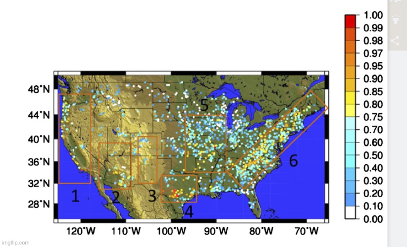
Figure 2 shows the observed flashiness across the CONUS. At this point, the true spatial distribution of flashiness is limited by the density of the USGS stations with defined flooding thresholds. However, several regions emerge as being prone to flash flooding: 1) the West Coast, 2) Arizona, 3) the Front Range, 4) Flash Flood Alley, 5) the Missouri Valley, and 6) the Appalachians. High flashiness in the West Coast region is restricted to the coastal basins and the upslope region of the Sierra Nevada near Lake Tahoe. Arizona hosts a large number of flashy basins that range from the low deserts in southeastern Arizona all the way up to the Mogollon Rim and the higher-terrain plateau in the northern part of the state. Several flashy basins are apparent just to the east of the Rocky Mountains in the Front Range region. In Texas, several flashy basins are clustered around San Antonio, Austin, and Waco along the Balcones Escarpment in what is locally known as Flash Flood Alley (Flood Safety Education Project 2005). There is a secondary cluster closer to the Gulf Coast near Houston. Moving farther to the northeast, flashiness increases and appears to maximize in the center of Missouri. The Appalachian Mountains in the eastern United States exhibit high values of flashiness from Georgia all the way to Maine.
Vehicle-Related Flood Fatalities in Texas, 1959–2019
Texas has the highest number of flood fatalities and vehicle-related flood fatalities in the United States. This study provides a detailed analysis of vehicle-related flood fatalities in Texas from 1959 to 2019. The data was compiled from the Storm Data publication maintained by the National Weather Service and includes demographics of the victims, dates, flood types, roadway types, and fatality location. There were 570 vehicle-related flood fatalities during the study period, with almost all fatal accidents resulting in one fatality. These fatalities represent 58% of total flood fatalities. The spatial analysis reveals that most counties with high vehicle-related flood fatalities are clustered in Flash Flood Alley. These counties accounted for over 80% of the fatalities. The annual distribution of these fatalities follows a statistically significant decreasing trend. Monthly distribution of vehicle-related fatalities follows that of rainfall in the Flash Flood Alley, with flash floods causing 61% of all vehicle-related flood fatalities. Night was the time of the day when the most vehicle-related deaths occurred. Males accounted for 63% of the fatalities and the age group of 20–29 was the most affected. The study discusses how the results can be used to increase awareness of flood hazards, used as input into state and regional disaster mitigation plans, and help tailor education and outreach programs….
Floods and Extreme Weather
In Texas, especially in central Texas and West Texas, flash floods are a common and real danger. In hilly terrain, flash floods can strike with little or no advance warning. Be aware of changes in the weather and seek higher ground early. Watch for water rising rapidly in streams and rivers. Watch for unusually hard rain over several hours or steady substantial rain over several days. Never camp on low ground next to streams, bottoms of canyons or deep arroyos since a flash flood can catch you while you're asleep. Distant rain may be channeled into gullies and ravines, turning a quiet stream into a deadly torrent in minutes. Water travels fast - if it's raining upstream you can be flooded even if the sky is clear overhead…
Mapping Flash Flood Severity in the United States…
Figure 2 shows the observed flashiness across the CONUS. At this point, the true spatial distribution of flashiness is limited by the density of the USGS stations with defined flooding thresholds. However, several regions emerge as being prone to flash flooding: 1) the West Coast, 2) Arizona, 3) the Front Range, 4) Flash Flood Alley, 5) the Missouri Valley, and 6) the Appalachians. High flashiness in the West Coast region is restricted to the coastal basins and the upslope region of the Sierra Nevada near Lake Tahoe. Arizona hosts a large number of flashy basins that range from the low deserts in southeastern Arizona all the way up to the Mogollon Rim and the higher-terrain plateau in the northern part of the state. Several flashy basins are apparent just to the east of the Rocky Mountains in the Front Range region. In Texas, several flashy basins are clustered around San Antonio, Austin, and Waco along the Balcones Escarpment in what is locally known as Flash Flood Alley (Flood Safety Education Project 2005). There is a secondary cluster closer to the Gulf Coast near Houston. Moving farther to the northeast, flashiness increases and appears to maximize in the center of Missouri. The Appalachian Mountains in the eastern United States exhibit high values of flashiness from Georgia all the way to Maine.
This post was edited on 7/6/25 at 6:38 pm
Posted on 7/6/25 at 6:40 pm to Neutral Underground
All I know is lake travis has risen over 7 ft. Gotta kinda be related
Posted on 7/6/25 at 6:42 pm to Neutral Underground
quote:
I didn't know a Tropical system passed over the area. That explains a lot.
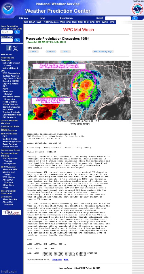
Technically, a tropical system, Barry only provided the mid level moisture fetches. The real villain was the rare formation of a warm core low on the late evening of July 3, between San Angelo and Midland. This thing exploded just north of San Angelo around 200ish am with 15" rain amounts and points due east in the matter of hours. These systems are very rare and difficult to forecast. Despite that the NWS had watches out by the time the catastrophic rains began.
It was just a tragic event. I dont see anyone at fault.
Posted on 7/6/25 at 6:45 pm to Neutral Underground
It's done it several times since the 70's.
Elevation and rocks leave little avenue for large amounts of water to go.
Storms churned at 2-3 inches and hour for several hours upriver.
That's it.
Unfortunately, it happened in the middle of the night.
Elevation and rocks leave little avenue for large amounts of water to go.
Storms churned at 2-3 inches and hour for several hours upriver.
That's it.
Unfortunately, it happened in the middle of the night.
Posted on 7/6/25 at 6:46 pm to Neutral Underground
It came from rain. Like the water in North Carolina Like the many other floods that have occurred.
Until you live out west and see heavy rain on a mountain, desert, or in a canyon you do not understand how fast it runs off.
Everyone is warned to stay out of river beds even if they are dry. Rains 30 miles away an wash you away with no warning.
Until you live out west and see heavy rain on a mountain, desert, or in a canyon you do not understand how fast it runs off.
Everyone is warned to stay out of river beds even if they are dry. Rains 30 miles away an wash you away with no warning.
Posted on 7/6/25 at 6:48 pm to Red_and_black
I read earlier that the NWS had 5 meteorologists on staff that night. Messages went out.
It was just shitty timing and tragic. A normal overnight is 2.
It was just shitty timing and tragic. A normal overnight is 2.
This post was edited on 7/6/25 at 6:49 pm
Posted on 7/6/25 at 6:53 pm to Neutral Underground
Rain dibtshit. When it rains in the hills it goes down said hills. That's when math kicks in.
(Didn't explain physics in the first part because it would be a waste of time)...
(Didn't explain physics in the first part because it would be a waste of time)...

Posted on 7/6/25 at 6:58 pm to wareagle7298
quote:
The Soros Aquifor
Soros' evil mind just can't stop. Made it rain up in here! Jewish international cabal strikes again!


Posted on 7/6/25 at 6:58 pm to Neutral Underground
Ask North Carolina. Topography and lots of rain
Posted on 7/6/25 at 7:01 pm to Neutral Underground
If you're interested in learning about it. Google Hydraulic time of concentration Guadalupe River Water Basin.
Understanding the principles of time of concentration will help you understand why flooding is different in various watersheds and how topography comes into play.
Understanding the principles of time of concentration will help you understand why flooding is different in various watersheds and how topography comes into play.
Posted on 7/6/25 at 7:03 pm to Neutral Underground
For perspective, these numbnuts were able to create this with a few shovels and their bare hands in under a hour…now imagine an entire watershed emptying into a dry, precut channel named the Guadalupe River.
A time bomb just waiting for a summer thunderstorm to set it off.
A time bomb just waiting for a summer thunderstorm to set it off.

Posted on 7/6/25 at 7:08 pm to Neutral Underground
cloud seeding via HAARP

Loading Twitter/X Embed...
If tweet fails to load, click here.This post was edited on 7/6/25 at 7:10 pm
Posted on 7/6/25 at 7:10 pm to Boomdaddy65201
this houston tv weather guy gives a good explanation of this weather event
Posted on 7/6/25 at 7:18 pm to Neutral Underground
I was on that river back in 2007 . 14 people died that day. We had some people tube by us and told us we need to get off the river because there was a big wall of water coming. We kept thinking no way because it hadn’t rained a drop. Sure shite about an hour later the water started to come up. We waded off the rocks and up to land then back up to our rental house. What we watched after that was sheer disbelief. But I’ll say it was nothing compared to what we are watching today. It had rained its arse off miles upstream and not a drop where we were. I remember the military choppers coming in and out and I so vividly remember the RV campground looking like a war zone .
Posted on 7/6/25 at 7:40 pm to Neutral Underground
Clouds.
What the frick. People act like we never had bad weeks and natural disasters until about 1990.
What the frick. People act like we never had bad weeks and natural disasters until about 1990.

Posted on 7/6/25 at 7:54 pm to Tigerfan1274
quote:
11 inches over thousands of acres, all funneling into one water body.
And even with all of that canyon lake is only about 64% full.
An event like this would need to happen two more times to fill it up That's how low it had gotten from the drought.

Posted on 7/6/25 at 8:09 pm to Privateer 2007
quote:
It rained.
That area has had flooding for thousands of years.
Why camp in such an obvious flood zone?

Posted on 7/6/25 at 8:11 pm to Neutral Underground
Ground is really dry. That area is not used to bunch of rain. Also very hilly, so the water follows gravity and surges to the lowest area…. Quickly.
It’s not government weather machines, it’s not climate change. Crazy rainfall happens sometimes.
People think hurricanes are getting worse but the reality is that we are just building more expensive shite where the hurricanes go.
It’s not government weather machines, it’s not climate change. Crazy rainfall happens sometimes.
People think hurricanes are getting worse but the reality is that we are just building more expensive shite where the hurricanes go.

 Page 2 of 6

Back to top