- My Forums
- Tiger Rant
- LSU Recruiting
- SEC Rant
- Saints Talk
- Pelicans Talk
- More Sports Board
- Fantasy Sports
- Golf Board
- Soccer Board
- O-T Lounge
- Tech Board
- Home/Garden Board
- Outdoor Board
- Health/Fitness Board
- Movie/TV Board
- Book Board
- Music Board
- Political Talk
- Money Talk
- Fark Board
- Gaming Board
- Travel Board
- Food/Drink Board
- Ticket Exchange
- TD Help Board
Customize My Forums- View All Forums
- Show Left Links
- Topic Sort Options
- Trending Topics
- Recent Topics
- Active Topics
Started By
Message

 0
0

Posted on 5/30/19 at 11:26 am to upgrade
quote:
The Old River Control Structure was finished in 1963. It’s purpose was to keep the Mississippi River in its current path. Baton Rouge and New Orleans were already along the river as well as industry.
Can you not see any logic in what I am saying?
He’s talking about the levee system built after the 1927 flood.
It does seem at least debatable at this point whether that was the right response to flooding.
It did allow development (over-development?) of Baton Rouge and especially New Orleans, but is that a good thing? And even if so, was it worth the cost?
Is it the reason we are losing coastline?
If the river changes course anyway now, it will certainly be seen as an enormous mistake. Right?
Posted on 5/30/19 at 11:28 am to uway
Just found this instructional because I see a lot of confusion over the basic layout.

This post was edited on 5/30/19 at 11:39 am
Posted on 5/30/19 at 11:30 am to AlxTgr
Bad link
Posted on 5/30/19 at 11:31 am to uway
This is what he linked
Posted on 5/30/19 at 11:33 am to uway
I’m not sure I see a way to truly adapt and use this area without the levees. Maybe I am obtuse.
Posted on 5/30/19 at 11:39 am to 9Fiddy
Thanks. I accidentally hit quote.
Posted on 5/30/19 at 11:52 am to tgrbaitn08
Great, so now the government is blocking canals for rich landowners? With MY tax dollars? I bet CCA is behind this.
Posted on 5/30/19 at 12:03 pm to upgrade
quote:
So if left alone to take the path of the Atchafalya, would it be deep enough for ship traffic?
EVENTUALLY it will. But how long would that take?
Prior to the ORCS the Atchafalaya was one of the worlds deepest rivers due to its slope, it is almost like you live in a world devoid of facts despite having all of mankinds knowledge at your fingertips.
If you dont feel like reading the whole thing start about half way down.
LINK
Posted on 5/30/19 at 12:18 pm to cave canem
There’s some salty folks up in here today 

Posted on 5/30/19 at 12:49 pm to jorconalx
i wish we had google earth historic photos from the 15th century on....i'd love to see the meandering playout in photos
Posted on 5/30/19 at 12:51 pm to uway
quote:
He’s talking about the levee system built after the 1927 flood.
It goes much farther back than that, the ORCS sealed off the LAST remaining distributary of the MS, there were far more of them.
Posted on 5/30/19 at 1:00 pm to cave canem
cave, that's a great read....
Posted on 5/30/19 at 1:09 pm to cave canem
quote:
Prior to the ORCS the Atchafalaya was one of the worlds deepest rivers due to its slope,
I'm guessing the river would flush out the sediment at mouth of Main and Wax Deltas. The problem is the water is only 15-20' deep out to around 20 miles offshore. It would take a while for it to be a viable deep water port unless they did something very creative.

Posted on 5/30/19 at 1:13 pm to Capt ST
That’s the issue with the Mississippi. In the study put out a few years ago Changing Course or whatever, a shorter route from around myrtle grove straight south to the gulf was depicted. But you would still have to dredge a deep arse channel and maintain it the whole way to deep water versus having the MS river velocity helping self scour to an extent.
Posted on 5/30/19 at 1:16 pm to Croacka
quote:
i wish we had google earth historic photos from the 15th century on....i'd love to see the meandering playout in photos
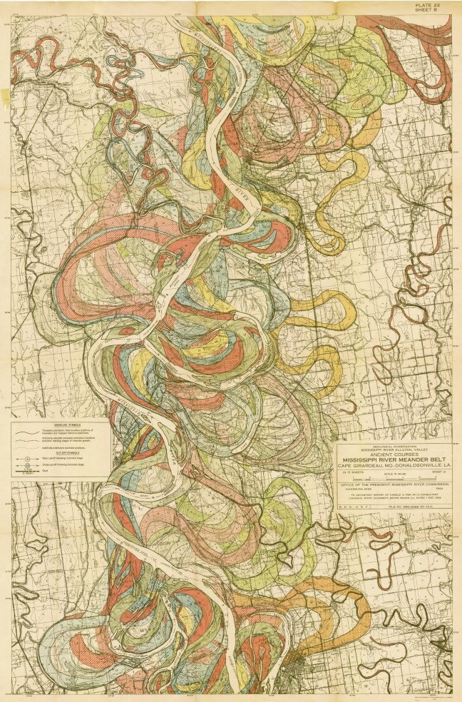
they have some pretty awesome hydrographic maps of it
Posted on 5/30/19 at 1:35 pm to celltech1981
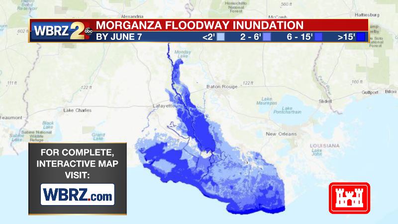
I’m new here. Can someone explain to me the possible ramifications if the Morganza spillway is not opened? Are we talking seepage causing levees to give way further south?
Posted on 5/30/19 at 1:40 pm to Undertow
Posted on 5/30/19 at 1:41 pm to Undertow
Spill way topped
Pressure on levees
Levees topped
Pressure on levees
Levees topped

 Page 7 of 9

Popular
Back to top