- My Forums
- Tiger Rant
- LSU Recruiting
- SEC Rant
- Saints Talk
- Pelicans Talk
- More Sports Board
- Fantasy Sports
- Golf Board
- Soccer Board
- O-T Lounge
- Tech Board
- Home/Garden Board
- Outdoor Board
- Health/Fitness Board
- Movie/TV Board
- Book Board
- Music Board
- Political Talk
- Money Talk
- Fark Board
- Gaming Board
- Travel Board
- Food/Drink Board
- Ticket Exchange
- TD Help Board
Customize My Forums- View All Forums
- Show Left Links
- Topic Sort Options
- Trending Topics
- Recent Topics
- Active Topics
Started By
Message
re: Why Do The Audubon & Gramercy Bridges Exist?
Posted on 2/11/20 at 1:27 pm to LuckyTiger

Posted on 2/11/20 at 1:27 pm to LuckyTiger
If you ever try to drive across the river in those places without using them, you'll know why. 
 1
1


Posted on 2/11/20 at 1:27 pm to LuckyTiger
quote:
I’ve driven across the Gramercy multiple times and, after crossing the river, the road dead ends in a field and turns around to a two lane road by the levee.
This post was edited on 2/11/20 at 1:37 pm

Posted on 2/11/20 at 1:27 pm to LuckyTiger
I'm not joking. Made it much safer. That was a dangerous intersection.
Posted on 2/11/20 at 1:28 pm to LuckyTiger
Years ago I read an article online that explained the political favors and process that went into placing the Audubon Bridge where it is. The webpage looked shitty like it was created on angel fire or something and I have never been able to find it again.
Posted on 2/11/20 at 1:32 pm to Nado Jenkins83
Oh I hear you.
Posted on 2/11/20 at 1:32 pm to MotorbikeMike
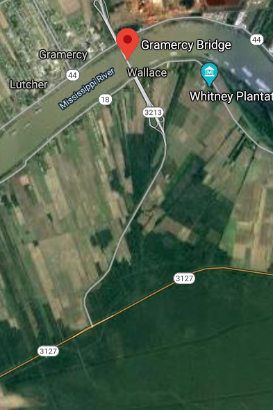
The LA 3127 tie-in from the Gramercy bridge was always planned since the bridge was built. But like the bridge that sat stalled above the levee for many years, the tie-in to LA 3127 took many years to complete. The tie-in opened in 2009, over 10 years ago. I don't use the bridge often, but I do use LA 3127 and see that the Gramercy bridge has very large usage in the mornings and evenings for plant commuters. There is even a traffic light at the 3127 intersection now. It would not surprise me if the Gramercy bridge crossings totaled into the thousands per day.
Posted on 2/11/20 at 1:33 pm to LuckyTiger
If you look at it on a map, DOTD could complete 3127 all the way to Gross Tete and you could extend to i-55. Therefore, you have a ready-made loop that the majority of the land for a 4 - lane highway is in place. It could be further connected to the Audubon bridge and you would have a route North to bypass BR and East to bypass BR. It would connect to 61, 190, LA-1, Hwy 70, Airline below Gonzales, Hwy 90, and I-310. If the State was serious and wanted a fast route to bypass BR, this is ready-made for it.
Posted on 2/11/20 at 1:35 pm to Nado Jenkins83
quote:
They even put a light at 3127 there.
When?
Posted on 2/11/20 at 1:37 pm to LuckyTiger
Audubon was legislated in 1989. The idea was to provide a northern loop and create economic development in the area.
Gramercy is for the plants and is heavily used.
Gramercy is for the plants and is heavily used.
Posted on 2/11/20 at 1:37 pm to tiger94gop
quote:
If you look at it on a map, DOTD could complete 3127 all the way to Gross Tete and you could extend to i-55. Therefore, you have a ready-made loop that the majority of the land for a 4 - lane highway is in place. It could be further connected to the Audubon bridge and you would have a route North to bypass BR and East to bypass BR. It would connect to 61, 190, LA-1, Hwy 70, Airline below Gonzales, Hwy 90, and I-310. If the State was serious and wanted a fast route to bypass BR, this is ready-made for it.
I can’t imagine how many and how long the studies would be for all of that.
Posted on 2/11/20 at 1:41 pm to LuckyTiger
The bridge you speak of was part of the TIMED program passed by the legislature and voted on by the people. It was paid for by a 4 cent gas tax.
"The TIMED (Transportation Infrastructure Model for Economic Development) Program was a $5.2 billion transportation infrastructure program designed to increase economic development in Louisiana by investing in transportation improvement projects. The program began in 1989 when voters approved a 4¢/gallon tax on gasoline to fund the projects designated by Act 16 of the 1989 Louisiana legislature. The TIMED program included widening over 500 miles of state highways to four lanes on 11 project corridors, widening and/or new construction on three major bridges, and improvements to both the Port of New Orleans and Louis Armstrong International Airport."
"The TIMED (Transportation Infrastructure Model for Economic Development) Program was a $5.2 billion transportation infrastructure program designed to increase economic development in Louisiana by investing in transportation improvement projects. The program began in 1989 when voters approved a 4¢/gallon tax on gasoline to fund the projects designated by Act 16 of the 1989 Louisiana legislature. The TIMED program included widening over 500 miles of state highways to four lanes on 11 project corridors, widening and/or new construction on three major bridges, and improvements to both the Port of New Orleans and Louis Armstrong International Airport."
Posted on 2/11/20 at 1:42 pm to Tiger-Striped-Bass
Side note- as I've been told, the Gramercy bridge was originally intended to align with LA20 in Vacherie on the westbank, which would make more sense, since LA 20 goes all the way to Houma (LA24 extension) and also connects with LA 3127 as well. but there was a geological fault that forced the relocation to where it is, shifted a few miles east. I've heard there was a big land grab when those politically connected in the area heard of the bridge plans, expecting to make huge profits on re-sale for the bridge. But the fault upended that. Not sure how true.
Posted on 2/11/20 at 1:42 pm to LuckyTiger
quote:
I can’t imagine how many and how long the studies would be for all of that.
If Trump restricts the permitting requirements of the Corps and FHWA it wouldn't be bad.
Posted on 2/11/20 at 1:43 pm to LuckyTiger
quote:
I’ve only driven across the Audubon once but when I did there was only one other car on it. I’ve driven across the Gramercy multiple times and, after crossing the river, the road dead ends in a field and turns around to a two lane road by the levee
look frickstick, you're not even a good troll. this has been discussed here ad nauseum - usually when the HW bridge backs up (which is daily). And you've probably never been on either. If you did, it was long ago as evidenced by your comment:
quote:
the road dead ends in a field and turns around to a two lane road by the levee.
both bridges are utilized sufficiently to justify their existence, if not their locations.
so STFU or post something interesting like a babe thread.

Posted on 2/11/20 at 1:44 pm to thegambler
quote:
The bridge you speak of was part of the TIMED program passed by the legislature and voted on by the people. It was paid for by a 4 cent gas tax.
"The TIMED (Transportation Infrastructure Model for Economic Development) Program was a $5.2 billion transportation infrastructure program designed to increase economic development in Louisiana by investing in transportation improvement projects. The program began in 1989 when voters approved a 4¢/gallon tax on gasoline to fund the projects designated by Act 16 of the 1989 Louisiana legislature. The TIMED program included widening over 500 miles of state highways to four lanes on 11 project corridors, widening and/or new construction on three major bridges, and improvements to both the Port of New Orleans and Louis Armstrong International Airport."
It's not as if all the bureaucratic gobbledygook doublespeak in the world will make it make any more sense, you know?
Posted on 2/11/20 at 1:46 pm to tigerinthebueche
Have a snickers.
Posted on 2/11/20 at 1:48 pm to Y.A. Tittle
quote:
The Audubon Bridge’s construction was part of the state’s Transportation Infrastructure Model for Economic Development Program, which was established by Act 16 of the 1989 legislative session. The program is funded with a dedicated 4-cents-per-gallon, voter-approved gas tax.
Mallett said the TIMED Program included 16 specific projects aimed at spurring economic development in Louisiana, not traffic congestion relief.

Posted on 2/11/20 at 1:48 pm to thegambler
quote:
The bridge you speak of was part of the TIMED program passed by the legislature and voted on by the people. It was paid for by a 4 cent gas tax.
"The TIMED (Transportation Infrastructure Model for Economic Development) Program was a $5.2 billion transportation infrastructure program designed to increase economic development in Louisiana by investing in transportation improvement projects. The program began in 1989 when voters approved a 4¢/gallon tax on gasoline to fund the projects designated by Act 16 of the 1989 Louisiana legislature. The TIMED program included widening over 500 miles of state highways to four lanes on 11 project corridors, widening and/or new construction on three major bridges, and improvements to both the Port of New Orleans and Louis Armstrong International Airport."
the TIMED program paid for the Audubon bridge. I've head the alignment was built right through some politicians land.
Posted on 2/11/20 at 1:48 pm to LuckyTiger
quote:
Have a snickers.
try to have an original thought to start a post.
Posted on 2/11/20 at 1:53 pm to LuckyTiger
Baton Rouge would just mess it up.

 Page 2 of 7

Popular
Back to top