- My Forums
- Tiger Rant
- LSU Recruiting
- SEC Rant
- Saints Talk
- Pelicans Talk
- More Sports Board
- Fantasy Sports
- Golf Board
- Soccer Board
- O-T Lounge
- Tech Board
- Home/Garden Board
- Outdoor Board
- Health/Fitness Board
- Movie/TV Board
- Book Board
- Music Board
- Political Talk
- Money Talk
- Fark Board
- Gaming Board
- Travel Board
- Food/Drink Board
- Ticket Exchange
- TD Help Board
Customize My Forums- View All Forums
- Show Left Links
- Topic Sort Options
- Trending Topics
- Recent Topics
- Active Topics
Started By
Message
Weather Experts tOT... Tornado Threat today & tomorrow?
Posted on 2/5/20 at 10:31 am
Posted on 2/5/20 at 10:31 am

quote:
Day 1 Convective Outlook
NWS Storm Prediction Center Norman OK
0653 AM CST Wed Feb 05 2020
Valid 051300Z - 061200Z
...THERE IS A SLIGHT RISK OF SEVERE THUNDERSTORMS TODAY AND TONIGHT
ACROSS PORTIONS OF THE LOWER MISSISSIPPI VALLEY AND SOUTHEAST...
...SUMMARY...
Severe thunderstorms are expected today and tonight across portions
of the lower Mississippi Valley and Southeast, with damaging wind
gusts and a few tornadoes.
...Synopsis...
The CONUS mid/upper-level pattern will be dominated by a major
synoptic trough -- initially extending from the Dakotas across CO to
northwestern MX -- and associated broadly cyclonic to southwesterly
flow to its east. The trough should move eastward gradually,
maintaining net positive tilt, as several shortwaves pivot through
it. By 12Z tomorrow, the trough should extend from the upper
Mississippi Valley across OK to north-central/central MX. Mid/upper
level southwesterlies (in the 500-250-mb layer) will intensify east
of the trough tonight, in a fetch from the TX Gulf Coast to the
upper Great Lakes.
Meanwhile, a strong but slow-moving surface cold front was analyzed
at 11Z from southern WV across eastern KY, becoming quasistationary
southwestward to a weak frontal-wave low between SHV-ESF, then a
cold front again across extreme southeast TX and the upper TX Coast,
to deep south TX. By 00Z, the low should ripple northeastward over
northern MS and western/middle TN, and the front should extend from
there to south-central LA and the northwestern Gulf. By 12Z, the
front should be located across eastern TN, central AL and
southeastern LA. A diffuse marine/warm front -- demarcating the
northern rim of best-modified boundary-layer air from the Gulf --
will spread inland across MS and much of AL, reaching southwestern
GA and the central FL Panhandle overnight.
...Southeast...
Episodic thunderstorm areas are forecast to move northeastward
across the region through tomorrow morning, offering the potential
for damaging winds and a few tornadoes.
At this time, the potential appears to be focused best in three
stages:
1. Prefrontal/warm-sector convection developing inland over MS and
into parts of northwestern AL during the day, as the air mass
gradually destabilizes from a combination of slow/diffuse diurnal
heating and boundary-layer theta-e advection. A persistent cone of
low-level confluent flow, with associated convergence amidst
weakening MLCINH, will support this activity. Mixed, potentially
messy storm modes are possible, along with some initially discrete
or embedded supercells, with flow aloft being largely parallel to
the zone of ascent.
2. Convection developing near the marine/warm front and farther
south into the optimally moist/high-theta-e Gulf warm sector this
afternoon into overnight. Coverage is very uncertain in this regime
due to the combination of weak CINH and weak forcing for ascent, but
some sustained/discrete storms are possible.
3. Near-frontal thunderstorms this afternoon through overnight --
initially over parts of LA/southeastern AR/MS and filling in
overnight as the frontal zone crosses the outlook area. Confidence
is greatest in relatively dense (scattered to numerous) storm
coverage in this regime, which also is likely to assume messy/quasi-
linear mode with time beneath nearly front-parallel flow. Still,
embedded supercells, bows and QLCS circulations will maximize severe
potential locally.
Convective coverage and longevity are still quite unclear,
especially in the first two regimes, given the "CAPE robber" stable
layer evident in midlevels in the 12Z LIX/JAN RAOBs, but not
upstream at LCH.
The warm sector will be characterized by increasing moisture/
buoyancy with southward extent toward the coast, favorable low-level
and deep shear area-wide, and stronger lift over northern and
frontal areas. Forecast soundings reasonably depict a broad area of
1000-2000 J/kg MLCAPE -- supported by surface dew points in the 60s
F, PW around 1.5 inches, and mean mixing ratios generally in the
13-15 g/kg range. Effective-shear magnitudes of 50-60 kt and
200-400 J/kg effective SRH should be rather common, which would
support tornado threats with any sustained/discrete cells, and
conditionally, significant-tornado potential given the parameter
space involved. Some subset of this broad risk area may be upgraded
once 12Z+ progs have arrived, and mesoscale trends become more
certain.
..Edwards/Kerr.. 02/05/2020
CLICK TO GET WUUS01 PTSDY1 PRODUCT
NOTE: THE NEXT DAY 1 OUTLOOK IS SCHEDULED BY 1630Z
CURRENT UTC TIME: 1628Z (10:28AM), RELOAD THIS PAGE TO UPDATE THE TIME
 9
9

Posted on 2/5/20 at 10:33 am to rt3
Schools are closing in Alabama in anticipation of it. Not sure how bad it’s supposed to be, but we’re certainly not hearing anything serious.
The storms that came through a few weeks ago were way more hyped than these.
The storms that came through a few weeks ago were way more hyped than these.
Posted on 2/5/20 at 10:33 am to rt3
Reed Timmer flew in last night to Tornado chase
Posted on 2/5/20 at 10:35 am to hubreb
quote:
Reed Timmer flew in last night to Tornado chase
yeah...Reed being out and chasing is what caught my eye too

ETA:

This post was edited on 2/5/20 at 10:37 am
Posted on 2/5/20 at 10:38 am to rt3
I know it’s middle of winter but it feels like a tropical island outside.
Posted on 2/5/20 at 11:21 am to sodcutterjones
quote:
I know it’s middle of winter but it feels like a tropical island outside.

Posted on 2/5/20 at 11:29 am to rt3
I wasn't expecting the Enhanced risk that far north.
Posted on 2/5/20 at 11:31 am to LegendInMyMind
Get used to it.
Posted on 2/5/20 at 11:31 am to sodcutterjones
Do you live in a sub-tropical climate region? It's quite common for it to be 70 degrees and 100 percent humidity in Feb in a sub-tropical climate region.
Sub Trop doesn't really have "Winter" at all. You have a base temp of around 69 degrees. Then as "winter" progresses, you have a series of cold fronts pass through, maybe about 6 per winter total. It's cold for a few days, then warms back up to the base temp. Then the cycle repeats.
Sub Trop doesn't really have "Winter" at all. You have a base temp of around 69 degrees. Then as "winter" progresses, you have a series of cold fronts pass through, maybe about 6 per winter total. It's cold for a few days, then warms back up to the base temp. Then the cycle repeats.
Posted on 2/5/20 at 11:37 am to LegendInMyMind
quote:
I wasn't expecting the Enhanced risk that far north.
It's close to where the developing surface low is going to pass. Better spin potential up there, especially as the lower level winds pick up and start pumping more warm air that way.
It's warmer down here, but not as much of a twist with the winds.

Posted on 2/5/20 at 11:40 am to LegendInMyMind
quote:
I wasn't expecting the Enhanced risk that far north.


Posted on 2/5/20 at 11:57 am to rt3
New tornado watch:
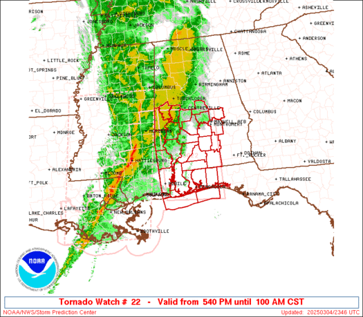
URGENT - IMMEDIATE BROADCAST REQUESTED
Tornado Watch Number 22
NWS Storm Prediction Center Norman OK
1150 AM CST Wed Feb 5 2020
The NWS Storm Prediction Center has issued a
* Tornado Watch for portions of
Central Louisiana
Central and Southwest Mississippi
* Effective this Wednesday morning and evening from 1150 AM until
600 PM CST.
* Primary threats include...
A few tornadoes likely with a couple intense tornadoes possible
Scattered damaging wind gusts to 70 mph possible
Isolated large hail events to 1.5 inches in diameter possible
SUMMARY...Thunderstorms are expected to continue to develop over
central Louisiana this afternoon and spread northeastward across the
watch area. A few supercell storms are possible, capable of
damaging winds and tornadoes.
Posted on 2/5/20 at 12:13 pm to Roll Tide Ravens
quote:
URGENT - IMMEDIATE BROADCAST REQUESTED Tornado Watch Number 22 NWS Storm Prediction Center Norman OK 1150 AM CST Wed Feb 5 2020 The NWS Storm Prediction Center has issued a * Tornado Watch for portions of Central Louisiana Central and Southwest Mississippi * Effective this Wednesday morning and evening from 1150 AM until 600 PM CST. * Primary threats include... A few tornadoes likely with a couple intense tornadoes possible Scattered damaging wind gusts to 70 mph possible Isolated large hail events to 1.5 inches in diameter possible SUMMARY...Thunderstorms are expected to continue to develop over central Louisiana this afternoon and spread northeastward across the watch area. A few supercell storms are possible, capable of damaging winds and tornadoes.
I don’t think shite is going to happen.
In the meantime while you’re monitoring the radar, notice how these storms seem as if they are developing out of thin air around the Houston area, then moving northeast.
Later in the day and into tomorrow, we’ll likely notice the same trend from Jackson and Biloxi area.
It’s weird as shite.
Posted on 2/5/20 at 12:46 pm to Phantom17
quote:
In the meantime while you’re monitoring the radar, notice how these storms seem as if they are developing out of thin air around the Houston area, then moving northeast.
Later in the day and into tomorrow, we’ll likely notice the same trend from Jackson and Biloxi area.
It’s weird as shite.
Cold air on the back side of that line from Houston to N Bama and warm air and gulf moisture on the front side.


Posted on 2/5/20 at 12:52 pm to Mr Personality

Posted on 2/5/20 at 1:22 pm to Phantom17
quote:
I don’t think shite is going to happen.
Imma go with the Storm Prediction Center over you.
Posted on 2/5/20 at 1:26 pm to Roll Tide Ravens
Lots of hail just passed through the CBD in NOLA.
Posted on 2/5/20 at 1:27 pm to Dizz
That was pretty wild
Posted on 2/5/20 at 1:30 pm to JohnnyKilroy
that had to be be a tornado or a microburst our building was shaking and Loyola Ave looked like a monsoon. construction barriers are all over the streets
construction debris smoked some cars on the parking garage roof across from it
construction debris smoked some cars on the parking garage roof across from it
This post was edited on 2/5/20 at 1:35 pm
Posted on 2/5/20 at 1:34 pm to CE Tiger
It was sure freaky to see the windows flexing. The hail hitting the windows sounded wild

 Page 1 of 5

Popular
Back to top