




- My Forums
- Tiger Rant
- LSU Recruiting
- SEC Rant
- Saints Talk
- Pelicans Talk
- More Sports Board
- Fantasy Sports
- Golf Board
- Soccer Board
- O-T Lounge
- Tech Board
- Home/Garden Board
- Outdoor Board
- Health/Fitness Board
- Movie/TV Board
- Book Board
- Music Board
- Political Talk
- Money Talk
- Fark Board
- Gaming Board
- Travel Board
- Food/Drink Board
- Ticket Exchange
- TD Help Board
Customize My Forums- View All Forums
- Show Left Links
- Topic Sort Options
- Trending Topics
- Recent Topics
- Active Topics
Started By
Message


 1
1

Posted on 4/12/19 at 11:32 pm to Duke
What’s Sunday morning along the Gulf Coast looking like?
Asking for a friend.
Asking for a friend.
Posted on 4/12/19 at 11:34 pm to BRgetthenet
quote:
What’s Sunday morning along the Gulf Coast looking like?
You want the OT’s forecast or the NWS expert forecast?


Posted on 4/12/19 at 11:35 pm to BRgetthenet
[quote]What’s Sunday morning along the Gulf Coast looking like?
Crowded. Spring Break.
Crowded. Spring Break.


Posted on 4/12/19 at 11:38 pm to Breauxsif
Who me?

Posted on 4/12/19 at 11:50 pm to BRgetthenet
quote:
What’s Sunday morning along the Gulf Coast looking like?
Might want to be a bit more specific.

Now to highlight the scary HRRR tonight vs the much better looking NAM. I've got rotating updrafts plotted with significant tornado parameters.
HRRR:

Just for 3 pm tomorrow. Shows a dangerous rotating updraft coming through good STP numbers. Would be likely producing a pretty strong tornado.
NAM:

Not as intense, only a few rotating updrafts to be found and in the marginal section of STP values.
Posted on 4/12/19 at 11:54 pm to Duke
I was talking about I-10 East around 10AM. 
Thanks.
Looks to be pretty smooth sailing.
Thanks.
Looks to be pretty smooth sailing.
Posted on 4/12/19 at 11:59 pm to BRgetthenet
3.50 % chance of rain for ya

Posted on 4/13/19 at 12:01 am to tgrbaitn08
I wouldn't know, and, going on a guess, neither would you. Hell I hope that dude is just looking for clicks; I damn sure would if I were in central LA.
That said, I can see where some person posting that would rub an (aparent) eternal optimist like you the wrong way: It does seem excessive!
I hope you got them crappie filets ready, you crawfishing SOB...
That said, I can see where some person posting that would rub an (aparent) eternal optimist like you the wrong way: It does seem excessive!
I hope you got them crappie filets ready, you crawfishing SOB...
Posted on 4/13/19 at 12:03 am to BRgetthenet
quote:
pretty smooth sailing
Until you get to the state line where you’ll see patchy delays

Posted on 4/13/19 at 12:08 am to BRgetthenet

Posted on 4/13/19 at 12:15 am to Paul Allen
quote:
Who me?
Who stuttered? What’s the lead guard’s name at the entrance of CCLA you phony?
Let TD’ings know
Posted on 4/13/19 at 12:17 am to Breauxsif
Everyone knows William you doofus

Posted on 4/13/19 at 12:54 am to Duke
There’s an intense T-storm heading NE from Texas towards Toledo Bend right now.
Posted on 4/13/19 at 12:56 am to Ghost of Colby
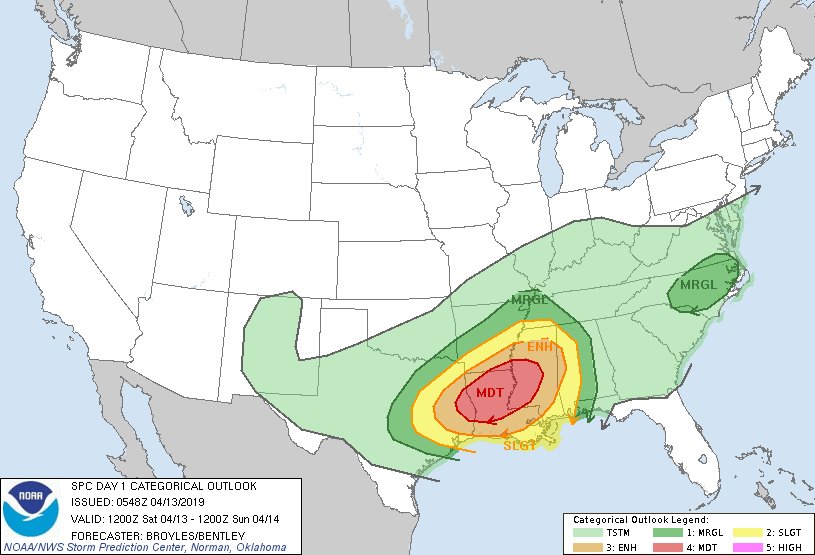
Moderate and Enhanced shifted a good bit south and east.

Posted on 4/13/19 at 12:56 am to Ghost of Colby
It’s already thundering its arse off here near Ruston. frick it’s going to be a long 24 hours


Posted on 4/13/19 at 12:59 am to lsuman25
Tornado probabilities for tomorrow through 7am Sunday:

From the Storm Prediction Center’s discussion:
From the Storm Prediction Center’s discussion:
quote:
A potential for long-track tornadoes will be possible and a regional outbreak of tornadoes could occur across parts of the moderate risk area. By early evening, the cluster of severe storms is forecast to move into southwestern and central Mississippi where a potential for strong tornadoes will continue. However, the wind-damage threat may become the more dominant hazard as the convection moves further to the east where instability is forecast to be weaker.
This post was edited on 4/13/19 at 1:02 am
Posted on 4/13/19 at 12:59 am to lsuman25

Tornado percentage

Wind percentage

Hail percentage
Posted on 4/13/19 at 1:06 am to lsuman25
Thought the moderate zone might shift south some, but not that much. It's knocking on BR's back door. Alexandria firmly in it now. Shreveport out of the moderate zone.

BR area getting in on that hatched tornado potential.

Damaging wind probabilities.

Hail earlier threat and the big stone throwers projected in E Texas.
BR area getting in on that hatched tornado potential.
Damaging wind probabilities.
Hail earlier threat and the big stone throwers projected in E Texas.

 Page 14 of 47

Popular
Back to top
 Follow TigerDroppings for LSU Football News