- My Forums
- Tiger Rant
- LSU Recruiting
- SEC Rant
- Saints Talk
- Pelicans Talk
- More Sports Board
- Fantasy Sports
- Golf Board
- Soccer Board
- O-T Lounge
- Tech Board
- Home/Garden Board
- Outdoor Board
- Health/Fitness Board
- Movie/TV Board
- Book Board
- Music Board
- Political Talk
- Money Talk
- Fark Board
- Gaming Board
- Travel Board
- Food/Drink Board
- Ticket Exchange
- TD Help Board
Customize My Forums- View All Forums
- Show Left Links
- Topic Sort Options
- Trending Topics
- Recent Topics
- Active Topics
Started By
Message
re: Tropical Storm Isaias - O Canada!
Posted on 7/26/20 at 10:13 am to rds dc
Posted on 7/26/20 at 10:13 am to rds dc
Multiple flash flood emergencies for deep S. Texas as the onshore flow is training over the same area from McAllen down to Brownsville.

Many stations down there reporting b/w 6 - 9" with some higher totals estimated by radar (stations are official reports and the overlay is radar estimated totals, the 1.3" at the Harlingen airport is either wrong or hasn't been updated since yesterday).

Many stations down there reporting b/w 6 - 9" with some higher totals estimated by radar (stations are official reports and the overlay is radar estimated totals, the 1.3" at the Harlingen airport is either wrong or hasn't been updated since yesterday).
This post was edited on 7/26/20 at 10:17 am
 3
3


Posted on 7/26/20 at 10:16 am to rds dc
Gonna be bad the next day or so for them... that’s a lot of rain that has to work it’s way through that area.

Posted on 7/26/20 at 11:55 am to dukke v
As Stevie Ray would say, "It's floodin' down in Texas..."
Posted on 7/26/20 at 12:16 pm to rds dc
Not a whole to say about 92L at this point. It is a rather large wave with a good bit of SAL over the top and now somewhat out in front of the wave. SAL over the top can actually have a net benefit for a wave moving across the MDR but the issues start when the SAL gets out in front of the wave.

The 12z GFS shows this being an issue with dry air entering the circulation as 92L tries to wrap up. You can see this as well on the storm centered sounding, if you pull that.

The GFS has this system battle the dry air but still start to wrap up with some deeper convection. This allows for it to slow down and start to lift north as it moves towards the islands. The Euro keeps the system weaker and moves it quickly along in the lower level flow to the west. This will be something to watch over the next few days and will impact the longer term track.
Right now the Euro favors the weaker farther south track and sits in the main EPS cluster.

The 12z GFS shows this being an issue with dry air entering the circulation as 92L tries to wrap up. You can see this as well on the storm centered sounding, if you pull that.
The GFS has this system battle the dry air but still start to wrap up with some deeper convection. This allows for it to slow down and start to lift north as it moves towards the islands. The Euro keeps the system weaker and moves it quickly along in the lower level flow to the west. This will be something to watch over the next few days and will impact the longer term track.
Right now the Euro favors the weaker farther south track and sits in the main EPS cluster.
Posted on 7/26/20 at 12:19 pm to rds dc
Well in terms people understand the Bermuda high is gonna control where this so called system will go.
Posted on 7/26/20 at 12:24 pm to dukke v
quote:
Well in terms people understand the Bermuda high is gonna control where this so called system will go.
Not really, the setup is a bit more complicated than that with a number of upper level features spinning around. What you are describing would be more of a classic later in August pattern.
Posted on 7/26/20 at 12:27 pm to rds dc
Look at your own map....... all I said was at this point that Bermuda high IS A factor on how this thing develops and where it might go......

Posted on 7/26/20 at 12:33 pm to dukke v
quote:
by: dukke v
quote:
re: Flood threat on northern Gulf coast Posted online on 8/11/16 at 6:57 am to GEAUXmedic
I just don't see the Baton Rouge area getting as much rain as predicted. Some strong showers but just not as bad. The New Orleans area will get a ton though.

Posted on 7/26/20 at 12:33 pm to dukke v
Is that 2nd storm going to enter the gulf? Trying to decide if I should bring my boat back to the camp or wait it out
Posted on 7/26/20 at 12:36 pm to redneck
If it stays weaker longer more of a chance it misses the weaknesses created by the disturbances. If it spins up faster would have a greater chance of feeling those weaknesses.
Posted on 7/26/20 at 2:00 pm to lsuman25
Euro kills it in the Caribbean.
Posted on 7/26/20 at 2:45 pm to lsuman25
quote:
Euro kills it in the Caribbean.
The Euro never allows for the wave axis to fold over and eventually the low level flow in the Caribbean accelerates. This keeps the system from fully closing off the circulation before opening back up into a wave.

Typically, this can open the door for development in the WCAB or Gulf but the Euro has an impressive trough over the Central US. This turns the Gulf into a shear kill zone and there is no chance for the system to develop on this run.

Posted on 7/26/20 at 3:18 pm to rds dc
All the models are shifting the track north. Question is whether it turns before it hits the Caribbean islands. Most of the intensity forecasts have it either as a cat 1 or tropical storm at its apex of strength.
Posted on 7/26/20 at 3:24 pm to rds dc
92L looks like it will be a nothingburger
Posted on 7/26/20 at 3:41 pm to deltaland
quote:
92L looks like it will be a nothingburger
I'm fine with that
Posted on 7/26/20 at 4:31 pm to SpotCheckBilly
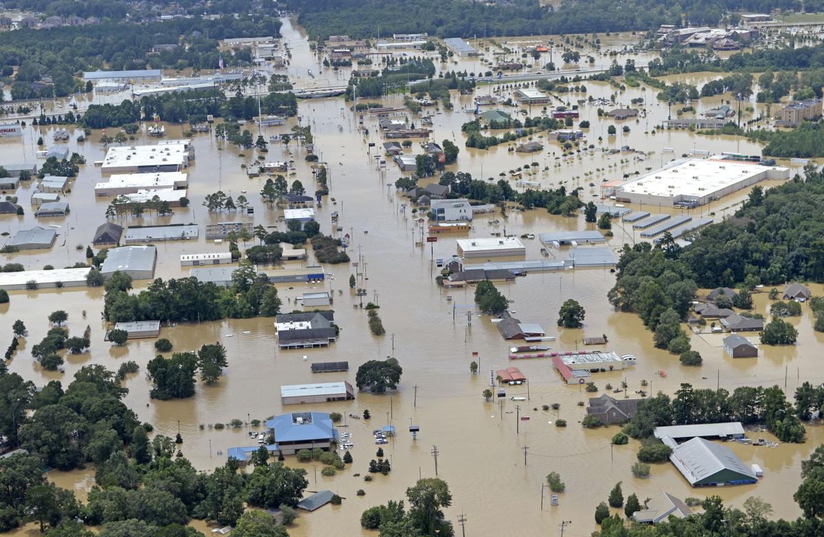
Some areas are showing 15" of rain so far.
Posted on 7/26/20 at 6:16 pm to FLObserver
Headed to SGI Saturday.......fine as hell with me!

Posted on 7/26/20 at 8:13 pm to FLObserver
As long as this storm produces some surf i will be happy surf has been shite the last 6 weeks

Posted on 7/26/20 at 11:28 pm to rds dc
quote:
impressive trough over the Central US
Doesn't seem like this is normal for the middle of summer
Posted on 7/27/20 at 6:43 am to rds dc
Any spaghetti models worth positing on the op?

 Page 25 of 50

Popular
Back to top