- My Forums
- Tiger Rant
- LSU Recruiting
- SEC Rant
- Saints Talk
- Pelicans Talk
- More Sports Board
- Fantasy Sports
- Golf Board
- Soccer Board
- O-T Lounge
- Tech Board
- Home/Garden Board
- Outdoor Board
- Health/Fitness Board
- Movie/TV Board
- Book Board
- Music Board
- Political Talk
- Money Talk
- Fark Board
- Gaming Board
- Travel Board
- Food/Drink Board
- Ticket Exchange
- TD Help Board
Customize My Forums- View All Forums
- Show Left Links
- Topic Sort Options
- Trending Topics
- Recent Topics
- Active Topics
Started By
Message
re: Tropical Storm Debby - Flooding Threat Slowly Shifting NE
Posted on 8/4/24 at 2:53 pm to Chucktown_Badger

Posted on 8/4/24 at 2:53 pm to Chucktown_Badger
 0
0


Posted on 8/4/24 at 2:56 pm to ReauxlTide222
quote:
Shore Acres
That area has been flooding for the past 20+ years. I'm shocked people are buying and not building up.
Posted on 8/4/24 at 3:33 pm to TheOcean
Looks like they expanded the High Risk a bit in the latest update:
Loading Twitter/X Embed...
If tweet fails to load, click here.Posted on 8/4/24 at 4:50 pm to LegendInMyMind
zoomed in view

Posted on 8/4/24 at 5:24 pm to NorthEndZone
Latest HWRF in line with GFS on a westward track back into the gulf after the Florida landfall
2nd landfall as a TS in New Orleans

Euro, HMON, Canadian, Icon all agree on the 2nd landfall being Georgia/Carolina
2nd landfall as a TS in New Orleans
Euro, HMON, Canadian, Icon all agree on the 2nd landfall being Georgia/Carolina
Posted on 8/4/24 at 5:26 pm to deltaland

Posted on 8/4/24 at 5:27 pm to Bobby OG Johnson
Somebody should lose their job over that. Thats stupid

Posted on 8/4/24 at 5:28 pm to Bobby OG Johnson
Thats what the cranes are supposed to do. Its better for them to spin in wind direction.
Posted on 8/4/24 at 5:31 pm to Bobby OG Johnson
Meanwhile, the Okefenokee Swamp is going to get wetter, will it make a play for adding acreage because the water is just going to sit there?
Posted on 8/4/24 at 5:46 pm to real turf fan
Getting overshooting tops now in the center
Posted on 8/4/24 at 5:47 pm to deltaland
quote:
Latest HWRF in line with GFS on a westward track back into the gulf after the Florida landfall 2nd landfall as a TS in New Orleans
I don’t think this happens with the heat ridge protecting LA this week
Posted on 8/4/24 at 6:08 pm to LegendInMyMind
quote:
Looks like they expanded the High Risk a bit in the latest update:
Now the entire Georgia coast is included. Was just Savannah.
Posted on 8/4/24 at 6:11 pm to Mr Roboto
quote:
I don’t think this happens with the heat ridge protecting LA this week
Both the GFS and the Euro have the ridge weakening to some degree. HWRF has a similar idea to the GFS as far as track, but gets it even farther west. The ridge to the west not being that strong/backing off shows up in all the models. The WAtl ridge builds back and closes the out-to-sea door. There's a very weak shortwave that passes through up North that isn't enough to sweep it up which is what keeps it drifting. If the ridge to the west weakens or retreats it could take the open path across the coast to the west.
This post was edited on 8/4/24 at 6:27 pm
Posted on 8/4/24 at 6:40 pm to NorthEndZone
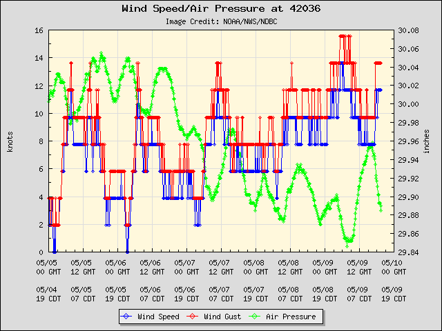
Center will be passing very close to this buoy in next 2-3 hours.

Posted on 8/4/24 at 6:47 pm to NorthEndZone
No sticky for this storm???
Interesting.
Interesting.
Posted on 8/4/24 at 6:48 pm to LegendInMyMind
IF this were to happen when would be a time to start noticing/be on the lookout?
Posted on 8/4/24 at 6:51 pm to NorthEndZone
Tornado warnings are going to pop up continuously, but this one is near fairly populated areas east of Sarasota.
quote:
...A TORNADO WARNING REMAINS IN EFFECT UNTIL 815 PM EDT FOR CENTRAL MANATEE AND NORTH CENTRAL SARASOTA COUNTIES...
At 747 PM EDT, a severe thunderstorm capable of producing a tornado was located over Lake Sarasota, or near Sarasota, moving north at 45 mph.
HAZARD...Tornado.
SOURCE...Radar indicated rotation.
IMPACT...Flying debris will be dangerous to those caught without shelter. Mobile homes will be damaged or destroyed. Damage to roofs, windows, and vehicles will occur. Tree damage is likely.
This dangerous storm will be near... Bradenton, Lakewood Ranch, North Sarasota, and The Meadows around 755 PM EDT.
Other locations impacted by this tornadic thunderstorm include Lake Manatee State Park, Desoto Lakes, Bee Ridge, and Fruitville.
Posted on 8/4/24 at 6:57 pm to NorthEndZone
One for Cape Canaveral a bit ago, too.
Posted on 8/4/24 at 6:59 pm to LPLGTiger
quote:
IF this were to happen when would be a time to start noticing/be on the lookout?
I honestly think it is just a wait and see deal. There's no consensus as to what happens after landfall. That's what happens when all major steering tries to break down.
Posted on 8/4/24 at 7:03 pm to dukke v
quote:
No sticky for this storm???
She'll be a cane at the next update, but she doesn't have time to become major.

 Page 38 of 49

Popular
Back to top