- My Forums
- Tiger Rant
- LSU Recruiting
- SEC Rant
- Saints Talk
- Pelicans Talk
- More Sports Board
- Fantasy Sports
- Golf Board
- Soccer Board
- O-T Lounge
- Tech Board
- Home/Garden Board
- Outdoor Board
- Health/Fitness Board
- Movie/TV Board
- Book Board
- Music Board
- Political Talk
- Money Talk
- Fark Board
- Gaming Board
- Travel Board
- Food/Drink Board
- Ticket Exchange
- TD Help Board
Customize My Forums- View All Forums
- Show Left Links
- Topic Sort Options
- Trending Topics
- Recent Topics
- Active Topics
Started By
Message
re: Tropical Storm Debby - Flooding Threat Slowly Shifting NE
Posted on 8/4/24 at 7:19 pm to NorthEndZone
Posted on 8/4/24 at 7:19 pm to NorthEndZone
Recon measured a 986.1 mb, but that is extrapolated. We'll see if they go with that or adjust it upward as they sometimes do.
And lowest pressure was a little NE of advisory position.
And lowest pressure was a little NE of advisory position.
 1
1

Posted on 8/4/24 at 7:21 pm to NorthEndZone
quote:
Recon measured a 986.1 mb, but that is extrapolated. We'll see if they go with that or adjust it upward as they sometimes do.
That works out to around 80 mph.

Posted on 8/4/24 at 7:28 pm to rds dc

Posted on 8/4/24 at 7:29 pm to Roll Tide Ravens
August hasn’t been friendly to the Big Bend area the last couple of years. Idalia last year and now Debby.
Posted on 8/4/24 at 7:39 pm to Roll Tide Ravens
They adjusted to 988. Still 4 mb drop in a short time.


Posted on 8/4/24 at 7:48 pm to Bestbank Tiger
quote:
Recon measured a 986.1 mb, but that is extrapolated.
Wait a minute, don’t tell me hurricane pressures are calculated like unemployment numbers by our government?
Posted on 8/4/24 at 8:21 pm to Meauxjeaux
quote:
Recon measured a 986.1 mb, but that is extrapolated.
Wait a minute, don’t tell me hurricane pressures are calculated like unemployment numbers by our government?
No conspiracy. Weather observations for hurricanes are based on surface conditions. When winds or pressure are recorded at flight level the data is extrapolated to surface conditions.
It is the reason why, when winds observed on a rig that is 150 feet up are lowered when used in the storm report.
This post was edited on 8/4/24 at 8:25 pm
Posted on 8/4/24 at 9:39 pm to Tarps99
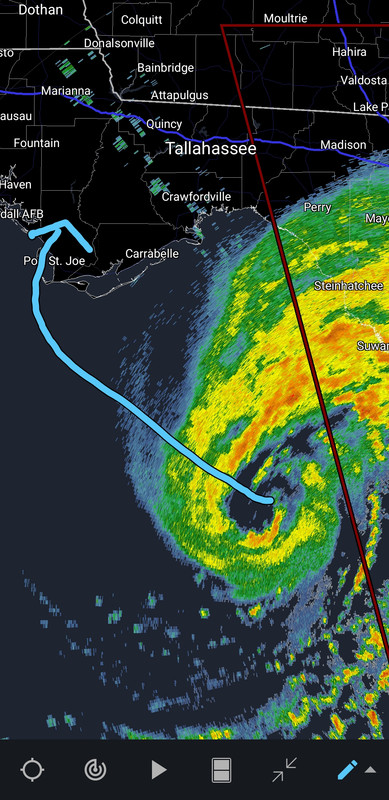
Man, it is gonna be one hell of a turn when it finally makes the move to make landfall west of Cape San Blas. I'm starting to think it isn't gonna do it.
Posted on 8/4/24 at 9:46 pm to LegendInMyMind
All quiet so far. Little rain, breezy
Posted on 8/4/24 at 9:56 pm to Tarps99
quote:
No conspiracy. Weather observations for hurricanes are based on surface conditions. When winds or pressure are recorded at flight level the data is extrapolated to surface conditions.
It is the reason why, when winds observed on a rig that is 150 feet up are lowered when used in the storm report.
OK well can handle that. Suck im so jaded about believing anything official anymore.
Posted on 8/4/24 at 9:57 pm to Meauxjeaux
Debby upgraded to a hurricane
Posted on 8/4/24 at 9:58 pm to Mr Roboto
..DEBBY BECOMES A HURRICANE AS IT APPROACHES THE NORTHEASTERN GULF COAST... ...WILL BRING A MAJOR FLOOD THREAT TO THE SOUTHEASTERN UNITED STATES THIS
WEEK...
11:00 PM EDT Sun Aug 4
Location: 28.6°N 84.0°W
Moving: N at 12 mph
Min pressure: 985 mb
Max sustained: 75 mph
WEEK...
11:00 PM EDT Sun Aug 4
Location: 28.6°N 84.0°W
Moving: N at 12 mph
Min pressure: 985 mb
Max sustained: 75 mph

Posted on 8/4/24 at 9:59 pm to ticklechain
Posted on 8/4/24 at 10:03 pm to CarolinaGamecock99
10 PM CDT advisory. We now have Hurricane Debby.

BULLETIN
Hurricane Debby Advisory Number 11
NWS National Hurricane Center Miami FL AL042024
1100 PM EDT Sun Aug 04 2024
...DEBBY BECOMES A HURRICANE AS IT APPROACHES THE NORTHEASTERN
GULF COAST...
...WILL BRING A MAJOR FLOOD THREAT TO THE SOUTHEASTERN UNITED
STATES THIS WEEK...
SUMMARY OF 1100 PM EDT...0300 UTC...INFORMATION
-----------------------------------------------
LOCATION...28.6N 84.0W
ABOUT 65 MI...105 KM WSW OF CEDAR KEY FLORIDA
ABOUT 100 MI...160 KM WNW OF TAMPA FLORIDA
MAXIMUM SUSTAINED WINDS...75 MPH...120 KM/H
PRESENT MOVEMENT...N OR 360 DEGREES AT 12 MPH...19 KM/H
MINIMUM CENTRAL PRESSURE...985 MB...29.09 INCHES
FORECAST POSITIONS AND MAX WINDS
INIT 05/0300Z 28.6N 84.0W 65 KT 75 MPH
12H 05/1200Z 29.8N 83.8W 75 KT 85 MPH
24H 06/0000Z 30.8N 83.0W 50 KT 60 MPH...INLAND
36H 06/1200Z 31.5N 82.1W 40 KT 45 MPH...INLAND
48H 07/0000Z 31.6N 81.0W 35 KT 40 MPH...OVER WATER
60H 07/1200Z 31.7N 80.1W 40 KT 45 MPH
72H 08/0000Z 32.1N 79.8W 45 KT 50 MPH
96H 09/0000Z 33.0N 79.8W 45 KT 50 MPH...INLAND
120H 10/0000Z 34.7N 79.6W 30 KT 35 MPH...INLAND
This post was edited on 8/4/24 at 10:06 pm
Posted on 8/4/24 at 10:04 pm to Roll Tide Ravens


Posted on 8/4/24 at 10:07 pm to CarolinaGamecock99
What in the frick is that shite??
Posted on 8/4/24 at 10:09 pm to Roll Tide Ravens
Seeing some Fujiwhara effect due to multiple inner cores consolidating…

Better view…
College of Dupage GOES
Fujiwhara effect
Better view…
College of Dupage GOES
Fujiwhara effect
This post was edited on 8/4/24 at 10:13 pm
Posted on 8/4/24 at 10:12 pm to Zapps4Life
I know the models don’t agree but looking at that gif this things headed straight for Tallahassee.

Posted on 8/4/24 at 10:43 pm to OysterPoBoy
There it is!!!!!!!!!!! 
Posted on 8/4/24 at 10:50 pm to Zapps4Life
Rewind back to Barrel for a second, because I just remembered to look.
Hurricane Beryl made the top five for the most prolific tornado producing Atlantic hurricanes on record. It barely beat out Andrew by six tornadoes. Beryl's final tally, stretching from TX fo NY, is 67, the most since Rita.
Hurricane Beryl made the top five for the most prolific tornado producing Atlantic hurricanes on record. It barely beat out Andrew by six tornadoes. Beryl's final tally, stretching from TX fo NY, is 67, the most since Rita.

 Page 39 of 49

Popular
Back to top