- My Forums
- Tiger Rant
- LSU Recruiting
- SEC Rant
- Saints Talk
- Pelicans Talk
- More Sports Board
- Fantasy Sports
- Golf Board
- Soccer Board
- O-T Lounge
- Tech Board
- Home/Garden Board
- Outdoor Board
- Health/Fitness Board
- Movie/TV Board
- Book Board
- Music Board
- Political Talk
- Money Talk
- Fark Board
- Gaming Board
- Travel Board
- Food/Drink Board
- Ticket Exchange
- TD Help Board
Customize My Forums- View All Forums
- Show Left Links
- Topic Sort Options
- Trending Topics
- Recent Topics
- Active Topics
Started By
Message
re: Storm Watch- Gulf- Tropical Depression- Northward Miss. Valley
Posted on 5/31/20 at 4:17 pm to oOoLsUtIgErSoOo
Posted on 5/31/20 at 4:17 pm to oOoLsUtIgErSoOo

TDsngumbo

 3
3

Posted on 5/31/20 at 4:25 pm to OleWarSkuleAlum
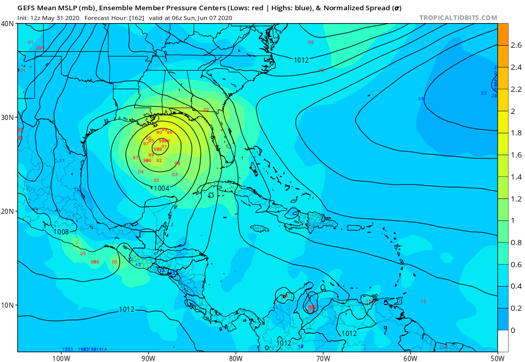
Quite a difference in forecasted pressure centers. 974-1000mb.
Stronger low if potential track goes northwest and weaker low center if it goes more northerly.
Would that be a by product of less shear ? Not understanding why the ensemble difference ?
Stronger low if potential track goes northwest and weaker low center if it goes more northerly.
Would that be a by product of less shear ? Not understanding why the ensemble difference ?
Posted on 5/31/20 at 4:27 pm to Klingler7
Steve Caprotta explained it great the weaker solutions are the one's that bury it in Mexico and the stronger ones develop it quicker and move northwest.

Posted on 5/31/20 at 4:29 pm to OleWarSkuleAlum
Yeah.. we don’t want a storm in la and lose power in 90 degree weather
No
No
Posted on 5/31/20 at 4:32 pm to t00f
Posted on 5/31/20 at 6:02 pm to lsuman25
Ok. I did not look at the forecasted hours over the Gulf. A 998-1000mb TC would historically equate to about a 50 knot (58 mph) sustained wind storm. My concern would be not the wind but rainfall as WPC has 4-8 inches of QPF along and East of 90 Degree West longitude in GOM thru 168 hours. If that path continued northward over land areas then Morgan city to Pensacola could see heavy rain potentially next weekend .
This post was edited on 5/31/20 at 6:03 pm
Posted on 5/31/20 at 11:43 pm to rds dc
This is now 93L but the models are in pretty good agreement that not much will happen over the next few days as the remnants of Amanda rotate around the larger circulation.
Notice the vort max associated with Amanda just south of Guatemala on the 00z GFS (the first image is rolled back 18 hrs) as it rotates around into the BOC and then eventually back into Mexico. This is pretty much inline with the last couple of Euro runs.

One thing to note, the Euro EPS over the next few days has many members with pressures that appear too low when comparing them against what the operational models are showing. The 12z EURO EPS at 96hrs is below and neither the 12z, 18z Euro or 12z, 18z, 00z GFS support the stronger ensemble members. This would be significant since a more organized system would have a better chance of strengthening once starting the trek north.

Notice the vort max associated with Amanda just south of Guatemala on the 00z GFS (the first image is rolled back 18 hrs) as it rotates around into the BOC and then eventually back into Mexico. This is pretty much inline with the last couple of Euro runs.
One thing to note, the Euro EPS over the next few days has many members with pressures that appear too low when comparing them against what the operational models are showing. The 12z EURO EPS at 96hrs is below and neither the 12z, 18z Euro or 12z, 18z, 00z GFS support the stronger ensemble members. This would be significant since a more organized system would have a better chance of strengthening once starting the trek north.

Posted on 6/1/20 at 7:59 am to rds dc

Posted on 6/1/20 at 8:38 am to paperwasp
thanks for the update, looks like chance of formation has been bumped up to 80% now
Posted on 6/1/20 at 8:56 am to Mudminnow
So now the big question is where is it headed

Posted on 6/1/20 at 8:58 am to Riolobo
Baytown to beaumont
Posted on 6/1/20 at 10:21 am to Nado Jenkins83
Happy Hurricane Season!
Posted on 6/1/20 at 10:24 am to rds dc
93L (remnants of Amanda) look pretty healthy this morning after crossing over the mountains of CA. The BOC is known for quick spin ups and conditions are somewhat favorable in the far southern portion of the BOC. The models are bringing the storm back SW into Mexico over the next few days and that area can quickly disrupt systems. However, if the storm stays out over the BOC before making the turn north than things could really change - see the 12z ICON. It gets really tricky as the outflow from a stronger system might be able to disrupt the upper level trough but a weaker system probably gets sheared by the upper levels as it moves north.


Posted on 6/1/20 at 10:27 am to rds dc
It is time.
Posted on 6/1/20 at 10:29 am to rds dc
In your opinion, how much time do we have until we get a more clear projection of where this thing could end up? Few days?
Posted on 6/1/20 at 10:33 am to The Boat
I'll wait till to see what PeeJ says before I go get gas for the generator.
Posted on 6/1/20 at 10:37 am to TheWiz
quote:
GFS has it arse-punching New Orleans.
How will Latoya handle this???

Posted on 6/1/20 at 11:02 am to rds dc
quote:
see the 12z ICON

Posted on 6/1/20 at 11:03 am to tgrbaitn08
I'm waiting on PJ as well. My go to authority on Tropical Storm landfalls.

Posted on 6/1/20 at 11:12 am to OleWarSkuleAlum
I've been very unbiased since the start of this thread. Do I enjoy the excitement that comes with the runup to a hurricane? Of course I do, what red-blooded south Louisianan man doesn't? But even though those ensembles show that, I still expect it to change a lot between now and landfall. In fact, as of this morning, everything is pointing toward a central/northeast Texas coast landfall more than a Louisiana landfall. The storm isn't even formed yet so there's plenty time for us to throw jabs at each other in this thread while we watch the models make asses of ourselves each time they update.

 Page 9 of 107

Popular
Back to top