- My Forums
- Tiger Rant
- LSU Recruiting
- SEC Rant
- Saints Talk
- Pelicans Talk
- More Sports Board
- Fantasy Sports
- Golf Board
- Soccer Board
- O-T Lounge
- Tech Board
- Home/Garden Board
- Outdoor Board
- Health/Fitness Board
- Movie/TV Board
- Book Board
- Music Board
- Political Talk
- Money Talk
- Fark Board
- Gaming Board
- Travel Board
- Food/Drink Board
- Ticket Exchange
- TD Help Board
Customize My Forums- View All Forums
- Show Left Links
- Topic Sort Options
- Trending Topics
- Recent Topics
- Active Topics
Started By
Message
re: Storm Watch- Gulf- Tropical Depression- Northward Miss. Valley
Posted on 5/27/20 at 6:58 pm to Prominentwon

Posted on 5/27/20 at 6:58 pm to Prominentwon
Dont worry. ‘Toya will keep this one quarantined.
 0
0


Posted on 5/27/20 at 7:02 pm to Zephyrius
I'm going to be driving to Biloxi. Will I be safe?

Posted on 5/27/20 at 8:04 pm to Prominentwon
quote:
Should I cancel my NOLA weekend???
Oh...wait...
Yes, go to Punta Cana instead.
Posted on 5/27/20 at 8:10 pm to AA77
"For those of you that don't habla Español, El Nino is Spanish for.....THE NINO!!"
This post was edited on 5/27/20 at 8:15 pm

Posted on 5/28/20 at 7:17 am to paperwasp
Euro now showing something in the gulf the last 2 runs.
Euro back [ON} OFF

Euro back [ON} OFF
This post was edited on 5/28/20 at 7:19 am

Posted on 5/28/20 at 8:28 am to Zephyrius
quote:
Euro now showing something in the gulf the last 2 runs
Interesting. GFS has less interaction with Yucatan than ECMWF, but now a sharper hook west.

Posted on 5/28/20 at 8:32 am to paperwasp
CAT 2 at 965 straight at Galveston.

Posted on 5/28/20 at 8:37 am to paperwasp
Yep... look at the isobars at the upper right corner toward the end of that run. Looks like it’s building a strong high pressure ridge building southward, pushing it westward.
Don’t let it fool you, though. Just about every run or two has been completely different than the previous. I’d expect it to continue its drastic changes until a week from now.
Don’t let it fool you, though. Just about every run or two has been completely different than the previous. I’d expect it to continue its drastic changes until a week from now.
This post was edited on 5/28/20 at 8:40 am
Posted on 5/28/20 at 9:12 am to TDsngumbo
quote:
Yep... look at the isobars at the upper right corner toward the end of that run. Looks like it’s building a strong high pressure ridge building southward, pushing it westward
I think you're exactly right. If this does eventually form, the placement of that ridge could be a steering mechanism, similar to the MCV feature we're seeing currently.

Posted on 5/28/20 at 9:25 am to PhillyTiger90
quote:Hurricane Audrey late June says hi.
A frickin Cat 3 in June is crazy

Posted on 5/28/20 at 9:33 am to TDsngumbo
quote:
I’d expect it to continue its drastic changes until a week from now.
I hope no one expects otherwise.
Posted on 5/28/20 at 9:35 am to paperwasp
quote:
I think you're exactly right. If this does eventually form, the placement of that ridge could be a steering mechanism, similar to the MCV feature we're seeing currently.
Something else to note there, in that particular run, is the disturbance off over the plains. That could indicate an eventual weakness or eroding of the ridge on the western side. If that were to happen, any hurricane in the northern gulf would probably begin to move northward toward that weakness.
Posted on 5/28/20 at 9:39 am to Teton Tiger
quote:
Hurricane Audrey late June says hi.
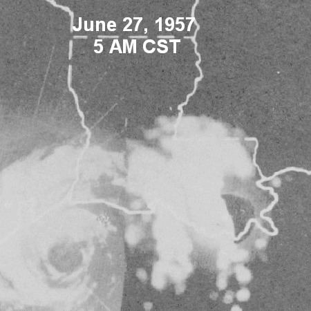
Audrey flattened Cameron Parish back then. It was the strongest June hurricane on record. It is very rare for a hurricane anywhere on the Gulf coast in the month of June and even more rare for a major one.


Posted on 5/28/20 at 9:53 am to TDsngumbo
Do we have a cone yet?
Posted on 5/28/20 at 10:08 am to OysterPoBoy
quote:
Do we have a cone yet?
Chris Jericho had a cone


Posted on 5/28/20 at 10:13 am to WestCoastAg
quote:
I'm going to be driving to Biloxi. Will I be safe?
If you stay on I-12 and avoid going through New Orleans? Probably. Just keep your eyes open through Slidell.
Posted on 5/28/20 at 1:56 pm to paperwasp
That can go frick itself
Posted on 5/28/20 at 2:18 pm to WestCoastAg
GFS- now has development in western Carribean heading towards Fl. keys 14 days out
Euro- developement in southern gulf meandering north 10 days out
CMS- development in southern gulf meandering north 10 days out
Euro- developement in southern gulf meandering north 10 days out
CMS- development in southern gulf meandering north 10 days out
Posted on 5/28/20 at 2:34 pm to Zephyrius
Prob need a rain by then
Posted on 5/28/20 at 7:15 pm to TIGRLEE

Special Tropical Weather Outlook...Corrected
NWS National Hurricane Center Miami FL
810 PM EDT Thu May 28 2020
For the North Atlantic...Caribbean Sea and the Gulf of Mexico:
Corrected website for the High Seas Forecast
Special Tropical Weather Outlook issued to discuss the area of low
pressure over the central Atlantic.
1. A surface trough and associated upper-level disturbance are
producing disorganized shower activity and gusty winds over the
central Atlantic Ocean several hundred miles east-southeast of
Bermuda. Gradual development of this system is possible, and it
could acquire some subtropical characteristics on Friday and
Saturday as it moves generally northward. Development is not
expected after that time due to unfavorable environmental
conditions. For additional information, see High Seas Forecasts
issued by the National Weather Service. The next Special Tropical
Weather Outlook on this system will be issued by 9 AM EDT Friday,
or earlier if necessary.
* Formation chance through 48 hours...low...30 percent.
* Formation chance through 5 days...low...30 percent.
Could we have a 3rd named system before the actual start of the season? Note: this will not come to the Gulf.

 Page 6 of 107

Popular
Back to top