- My Forums
- Tiger Rant
- LSU Recruiting
- SEC Rant
- Saints Talk
- Pelicans Talk
- More Sports Board
- Fantasy Sports
- Golf Board
- Soccer Board
- O-T Lounge
- Tech Board
- Home/Garden Board
- Outdoor Board
- Health/Fitness Board
- Movie/TV Board
- Book Board
- Music Board
- Political Talk
- Money Talk
- Fark Board
- Gaming Board
- Travel Board
- Food/Drink Board
- Ticket Exchange
- TD Help Board
Customize My Forums- View All Forums
- Show Left Links
- Topic Sort Options
- Trending Topics
- Recent Topics
- Active Topics
Started By
Message
re: Storm Aftermath - Hurricane Matthew will be Retired
Posted on 10/5/16 at 3:18 pm to slackster
Posted on 10/5/16 at 3:18 pm to slackster
quote:
This is the shitty catch-22 of forecasting the weather. Err on the side of caution and people remember things being overblown and disregard future warnings. Underestimate an event and the survivors will want your head on a stake.
Oh, of course.
I certainly am not one of those people.
I'm prepared, I literally have everything I need (shutters in place, enough food/water, etc), which is why I'm more inclined to get my family out of the way and stay myself to get ahead of the recovery process.
I'm not saying this won't be devastating, I'm speaking on my own experience, especially Jeanne of '04 which is pretty similar in tangibles to this storm - but hit my town dead on.
 1
1

Posted on 10/5/16 at 3:21 pm to NOLA1128
quote:
Oh, of course. I certainly am not one of those people.
Yeah I understand, just pointing out how everyone will be mad at the weather folks this weekend, but depending on your location, you'll think they either cried wolf or didn't give you enough warning.
Posted on 10/5/16 at 3:21 pm to NOLA1128
quote:
A little (big) difference between Andrew and Matthew.
I understand the need for precaution, but let's not be stupid.
A 130 mph hurricane as forecasted is no joke. Andrew had sustained winds of 160 mph. Also remember that intensity forecasting is not nearly as good as track forecasting. This thing could easily be a 150+ high Cat 4 just as easily as it could be a 115 mph low Cat 3.
Posted on 10/5/16 at 3:22 pm to otowntiger
Are any of the Orlando gas stations backing up yet? After Charlie, they had no gas to back up for.
I am over here in Methland and we will have 45-55 mph winds.
I am over here in Methland and we will have 45-55 mph winds.

Posted on 10/5/16 at 3:22 pm to grif82
Andrew was also a bigger storm overall.

Posted on 10/5/16 at 3:24 pm to GetCocky11
Any news on the status of I95 S tomorrow morning? Can't tell if they are doing contra flow going north only from that link. Thinking of going down 95 and hitting 16 to go west instead of going up 26.
Posted on 10/5/16 at 3:26 pm to PsychTiger
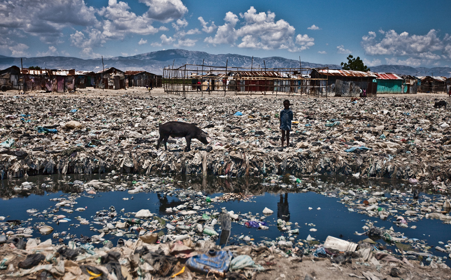
Picture of Haiti
Posted on 10/5/16 at 3:26 pm to grif82
quote:
A 130 mph hurricane as forecasted is no joke. Andrew had sustained winds of 160 mph. Also remember that intensity forecasting is not nearly as good as track forecasting. This thing could easily be a 150+ high Cat 4 just as easily as it could be a 115 mph low Cat 3.
I doubt it gets that high, but regardless, again, it's not like I'm saying "oh it's just another storm".
My family is safe.
I am safe unless my roof somehow blows off or a tree falls on my house.
I'm not saying this is a baby storm. I'm saying that comparing this thing to Hurricane Andrew and the devastation that caused in Homestead is just nowhere close (at least in what will happen in my neck of the woods).

Posted on 10/5/16 at 3:27 pm to ihometiger
I cant tell if thats normal or holy shite
Posted on 10/5/16 at 3:27 pm to Kcoyote
quote:
Andrew was also a bigger storm overall.
Not really.


Posted on 10/5/16 at 3:29 pm to NOLA1128
quote:
A little (big) difference between Andrew and Matthew.
I understand the need for precaution, but let's not be stupid.
Plus, Homestead at the time didn't exactly have the most up-to-par codes as is mentioned above.
My area is a little different, and I can only speak on my experiences. Again, I'm not too horribly concerned about this - as long as a tree doesn't land on my head.
The point was that a period of rapid intensification and this hurricane's path could very suddenly have a cat 5 crawling up the length of Florida and it's probably wise to not be in the "it's never that bad here" mindset. Those wind speeds are devastating, I don't care what kind of construction you have.
In any case, stay safe and good luck, my jort wearing friend!
This post was edited on 10/5/16 at 3:31 pm
Posted on 10/5/16 at 3:30 pm to Kcoyote
quote:
Andrew was also a bigger storm overall.
Matthew has a chance to affect much more coastline with the its maximum winds in or near the eyewall making it pretty much worst case scenario for Florida's Atlantic coast.
Posted on 10/5/16 at 3:30 pm to slackster
recon just flew through the center with a pressure of 959 so it could be strengthening now wait for recon to fly through the center again to see if pressures continue to fall.
Posted on 10/5/16 at 3:30 pm to ihometiger
quote:
Picture of Haiti
Pretty sure that is a "before" shot

Posted on 10/5/16 at 3:30 pm to NYNolaguy1
quote:
Two questions for the meteorologically informed on here
Paging PeeJ
Posted on 10/5/16 at 3:32 pm to TigerstuckinMS
quote:
my jort wearing friend!
From New Orleans.
frick the jorts.
Geaux Tigers. Who Dat
Posted on 10/5/16 at 3:36 pm to lsuman25
quote:
recon just flew through the center with a pressure of 959 so it could be strengthening now wait for recon to fly through the center again to see if pressures continue to fall.
Looks like it is starting to backfill moisture on the northern side of the storm - an area that was looking pretty ragged earlier today. The eye feature has disappeared but the overall convection seems to be picking up considerably and is trying to wrap around the southwest side of the center of circulation.

Posted on 10/5/16 at 3:38 pm to Hangit
by Methland do you mean Bithlo, or Polk County?
Posted on 10/5/16 at 3:38 pm to lsuman25
Matthew is still organizing after its brush with Cuba and Haiti. There's a deep blowup of convection on the N and E side of the center but it hasn't wrapped around yet. Probably won't until it's a little farther from Cuba.
Looking at the satellite now, I'm thinking if we see a rapid intensification it'll start churning overnight.
Looking at the satellite now, I'm thinking if we see a rapid intensification it'll start churning overnight.
Posted on 10/5/16 at 3:39 pm to slackster
I don't know how much a dropsonde cost, but dropping one every 10 or so miles from Biloxi to the Bahamas seems expensive. 


 Page 95 of 181

Popular
Back to top