- My Forums
- Tiger Rant
- LSU Recruiting
- SEC Rant
- Saints Talk
- Pelicans Talk
- More Sports Board
- Fantasy Sports
- Golf Board
- Soccer Board
- O-T Lounge
- Tech Board
- Home/Garden Board
- Outdoor Board
- Health/Fitness Board
- Movie/TV Board
- Book Board
- Music Board
- Political Talk
- Money Talk
- Fark Board
- Gaming Board
- Travel Board
- Food/Drink Board
- Ticket Exchange
- TD Help Board
Customize My Forums- View All Forums
- Show Left Links
- Topic Sort Options
- Trending Topics
- Recent Topics
- Active Topics
Started By
Message
re: States that border each other that you don’t view as border states
Posted on 1/3/24 at 6:16 pm to turnpiketiger
Posted on 1/3/24 at 6:16 pm to turnpiketiger
More on the city side, but El Paso is closer to Los Angeles than El Paso is to Houston.
 2
2

Posted on 1/3/24 at 6:56 pm to turnpiketiger
quote:
Mason Dixon line is so dumb. They decided to just go right down the middle of Delaware ?
We’re all just gonna let this comment go?

Posted on 1/3/24 at 6:59 pm to turnpiketiger
quote:
The same reason Florida doesn’t take the coast from Alabama
Alabama tried several times to get the panhandle.
Posted on 1/3/24 at 7:06 pm to BuckyCheese
quote:
I never understood why Wisconsin doesn't just take that from Michigan Yoopers have threatened to form their own state. They don't have much in common with lower Michigan.
If the UP joined Wisconsin then Wisconsin would flip to a red state. Michigan is blue regardless
Posted on 1/3/24 at 7:06 pm to Topwater Trout
Made this trip probably 40 times to camp and raft and fish the Nantahala. Wouldn’t expect anyone to know that didn’t live near by though
Posted on 1/3/24 at 7:27 pm to turnpiketiger
Almost as fun as time zones... There is a road in Arizona that changes time zones six times. Arizona, during the summer, is Pacific. The Navajo reservation follows federal law, which means during the summer they are Mountain. The Hopi, which is inside the Navajo lands, follows Arizona time, then back to Navajo, then back to Arizona.
The highway through the area goes (I think) Navajo, Hopi, Navajo, Hopi, Navajo, Arizona.
The highway through the area goes (I think) Navajo, Hopi, Navajo, Hopi, Navajo, Arizona.
Posted on 1/3/24 at 7:34 pm to turnpiketiger
Point Roberts is another good one. It is completely isolated from the U.S. because it should be part of Canada, but fell below the 49th parallel. To drive to the U.S., you have to drive cross a Canada checkpoint, then back through a border crossing into the U.S.. They were kind of screwed during the CoVID lockdown. Canada wouldn't let them in.

Posted on 1/3/24 at 8:16 pm to Buckeye Backer
quote:
Michigan and Wisconsin via the Upper Peninsula.
The Upper Peninsula doesn’t even touch Michigan never understood that one.

Posted on 1/3/24 at 8:17 pm to AUFANATL
quote:
Aren't there a few instances where a state border was set based on a river and then the river "moved" resulting in an island parcel of land that still belongs to a state but is now cutoff from the rest of it?
Plenty. All the way down the lower Mississippi Valley you’ll find land from a state on the wrong side of the river. Off the top of my head: Davis Island is on the Louisiana side but belongs to Mississippi.
This post was edited on 1/3/24 at 8:20 pm

Posted on 1/3/24 at 8:27 pm to turnpiketiger
quote:
Missouri and Tennessee
I always picture Missouri way farther east and more north in my mind than it is in reality. Like where Indiana is.
This post was edited on 1/3/24 at 8:27 pm
Posted on 1/3/24 at 8:42 pm to Planetarium
quote:
Isle Royale
Totally in Michigan.
Posted on 1/3/24 at 8:50 pm to BRich
Maryland's 2-3 western counties tried to petition to join WV a few years ago or something like that. If you've ever driven through the hell that is Interstate 68 through that stretch of Maryland, you know it's basically just West Virginia anyway.
Posted on 1/3/24 at 9:00 pm to DownSouthJukin
Giles island is the same I believe and a lot of eagle lake belongs to Louisiana.
Posted on 1/3/24 at 9:04 pm to turnpiketiger
Arkansas... because they are a midwestern state and we are in the south.

Posted on 1/3/24 at 9:07 pm to turnpiketiger
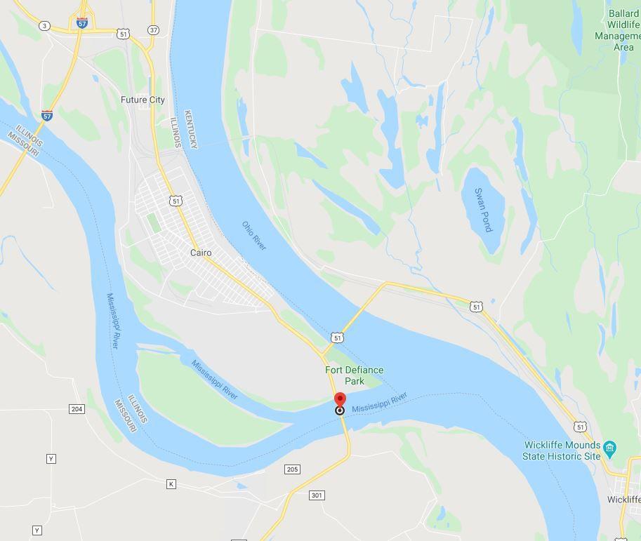
quote:
Kentucky and Missouri
The only way to cross from one to another is the Dorena-Hickman Ferry in Hickman, KY. The only way by road is to cross over Cairo Ohio River bridge from Wickliffe, KY into Cairo, Illinois. Take a left and cross over the Cairo Mississippi River bridge into Missouri.

Posted on 1/3/24 at 9:12 pm to I20goon
quote:what is Oklahoma?
they are a midwestern state and we are in the south

Posted on 1/3/24 at 9:14 pm to thegreatboudini
quote:
More on the city side, but El Paso is closer to Los Angeles than El Paso is to Houston.
I made this drive yesterday and it’s amazing how far El Paso is. Once you get passed it you finally feel like you accomplished something.

Posted on 1/3/24 at 9:22 pm to TheGasMan
quote:
quote:6 more hours and you're still in Virginia. what? DC to Emporia, VA is 3 hours as long as you’re not dealing with traffic.
He’s talking about I-81 down the western part of the state.
And for the record, Emporia VA is the armpit of the world and a speed trap.
Posted on 1/3/24 at 9:58 pm to Fun Bunch
quote:
Oregon and Nevada
quote:
Huh
I am aware that Oregon and Nevada share a rather extensive border but the region is so sparsely populated. Very forgettable area.
Posted on 1/3/24 at 11:08 pm to Locoguan0
Parts of Florida and Oregon are only 1 hour apart.

 Page 5 of 8

Popular
Back to top