- My Forums
- Tiger Rant
- LSU Recruiting
- SEC Rant
- Saints Talk
- Pelicans Talk
- More Sports Board
- Coaching Changes
- Fantasy Sports
- Golf Board
- Soccer Board
- O-T Lounge
- Tech Board
- Home/Garden Board
- Outdoor Board
- Health/Fitness Board
- Movie/TV Board
- Book Board
- Music Board
- Political Talk
- Money Talk
- Fark Board
- Gaming Board
- Travel Board
- Food/Drink Board
- Ticket Exchange
- TD Help Board
Customize My Forums- View All Forums
- Show Left Links
- Topic Sort Options
- Trending Topics
- Recent Topics
- Active Topics
Started By
Message
re: Severe weather threat continues today for parts of the southeast - Threat is Over.
Posted on 3/18/21 at 5:52 am to Malik Agar
Posted on 3/18/21 at 5:52 am to Malik Agar
quote:
How's it looking for Georgia and the Carolinas tomorrow?
Looks like all is good here in W.Central GA.
 1
1

Posted on 3/18/21 at 5:58 am to SteelerBravesDawg
We got nothing last night in Gwinnett.

Posted on 3/18/21 at 7:09 am to RiseUpATL
Remarkably, I don’t think there has even been an injury reported in Alabama from yesterday. Considering the severity of the risk and the tornadoes that we did see, that’s a true blessing from God. I think most people also took this threat very seriously.
As I mentioned yesterday, the last time we had a 45% tornado probability in this part of the country was April 27, 2011. Obviously, no one thought yesterday would be as bad as that, but the fact that this system didn’t even come close to justifying the 45% probability level shows how rare a day like 4/27/11 is.
As I mentioned yesterday, the last time we had a 45% tornado probability in this part of the country was April 27, 2011. Obviously, no one thought yesterday would be as bad as that, but the fact that this system didn’t even come close to justifying the 45% probability level shows how rare a day like 4/27/11 is.
This post was edited on 3/18/21 at 7:11 am

Posted on 3/18/21 at 7:55 am to Roll Tide Ravens
quote:
Remarkably, I don’t think there has even been an injury reported in Alabama from yesterday. Considering the severity of the risk and the tornadoes that we did see, that’s a true blessing from God. I think most people also took this threat very seriously.
Absolutely. I had that dread all day yesterday because I really thought that there was going to be death and destruction on a significant scale. Incredibly happy that there wasn't. Thankful.
Posted on 3/18/21 at 8:07 am to LegendInMyMind
quote:
I’m not buying the HRRR putting all those supercells in Alabama by 20z. I don’t wanna be that far from the mid level jet max. MS delta area into C MS is getting a perfect trough ejection this evening so sticking to the further west target.
He did wind up getting a brief video of a tornado in Woodville, Ms. That's pretty much the only storm he saw all day in his "favorite terrain to chase".
Honestly conditions here felt perfect. Why it didn’t materialize at all I don’t know

Posted on 3/18/21 at 8:07 am to Roll Tide Ravens
quote:
Remarkably, I don’t think there has even been an injury reported in Alabama from yesterday. Considering the severity of the risk and the tornadoes that we did see, that’s a true blessing from God.
Posted on 3/18/21 at 8:51 am to Roll Tide Ravens
quote:
April 27, 2011
That was the day of the super-cell long range twister that ran through middle and W.Central Georgia. It came w/in a 1/2 mile of one my best friend's house; twice.
You can still see the effects of that storm here.

Posted on 3/18/21 at 8:58 am to Roll Tide Ravens
I mean there were tornados though so the 45% probability hit, Just because there wasnt death/injury doesnt mean they werent there. The NWS probability charts are just that, the probability the event occurs. Now if you want to argue with some of the verbiage that was used (i didnt read any of their discussions so im not sure what was said) then go for it but going after the high risk/ probability indicators when those events did happen is not the play, in my opinion.
Posted on 3/18/21 at 9:13 am to Pedro
quote:
mean there were tornados though so the 45% probability hit
It’s a 45% probability of a tornado within 25 miles of any given point. Don’t misunderstand, I’m not saying SPC was wrong for putting it out, especially given the ingredients, I’m just saying that things didn’t end up reaching the level of how things typically are when there is a 45% tornado probability. Days with a 45% probability are exceptionally rare.
This post was edited on 3/18/21 at 9:20 am

Posted on 3/18/21 at 9:16 am to Roll Tide Ravens
SPC has fallen victim of social media culture which is why you see them use extreme threat levels they rarely use more often.
Posted on 3/18/21 at 9:22 am to Roll Tide Ravens
I gotcha. I can agree with that. Im just used to seeing clowns freak out saying "LOL THE METEOROLIGISTS frickED UP" or whatever but whenever you look at what they actually put out they were pretty much spot on.
There definitely is too much social media catering going on though (as boat said). Quite unfortunate.
There definitely is too much social media catering going on though (as boat said). Quite unfortunate.
Posted on 3/18/21 at 9:34 am to Pedro
quote:
gotcha. I can agree with that. Im just used to seeing clowns freak out saying "LOL THE METEOROLIGISTS frickED UP" or whatever but whenever you look at what they actually put out they were pretty much spot on.
Oh yeah, I am definitely against people acting like that. We should be glad that things weren’t as bad as they could have been if things had come together a bit differently.
Posted on 3/18/21 at 9:42 am to Pedro
quote:
Im just used to seeing clowns freak out saying "LOL THE METEOROLIGISTS frickED UP"
It's so annoying.
Posted on 3/18/21 at 9:46 am to Funky Tide 8
it really is. dont get me wrong. if they wiff then yea call em out. but most of the time people try to pull this gotcha crap theyre completely wrong
Posted on 3/18/21 at 10:47 am to Pedro
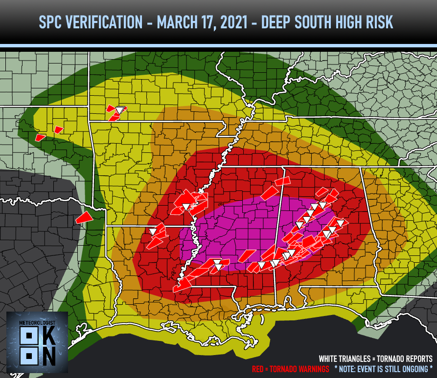
This is SPC's preliminary verification of the risk area yesterday. The red dots are tornado reports. There are a few interesting things: First, that the paths of numerous violent looking cells that went through places like Selma, AL, Billingsly, AL, and up to Chilton County, AL were actually on the very south edge of the 30% risk. That area ended up with more tornado activity that the 45% tornado probability area. In retrospect, the 45% probability area would have verified more had it been further southeast. Second, and probably most interesting, is the lack of tornado producing supercells across central Mississippi. All indicators were that there would be numerous tornadic cells forming in that area and moving into Alabama, but that just really didn't happen. Many of the cells that did produce tornadoes in Alabama were those that formed in Alabama.

This post was edited on 3/18/21 at 11:46 am
Posted on 3/18/21 at 11:20 am to Roll Tide Ravens
i think a huge saving grace for us in the Bham area was that it was overcast and foggy most all day - we didn't have any clearing or sunshine to really trigger the instability. if the day had cleared up in the morning and the sun had broken through the clouds, I think it would have been significantly worse.
the NWS is in a very un-enviable position when it comes to forecasts. if they don't try and strike the fear in people to take severe weather seriously, then if a tornado outbreak hits and people aren't prepared - then it opens them up to - you didn't sell the seriousness, or you didn't prepare us enough. people cannot accept responsibility for what they should be doing and paying attention to, instead of pointing the finger of blame at others.
the NWS is in a very un-enviable position when it comes to forecasts. if they don't try and strike the fear in people to take severe weather seriously, then if a tornado outbreak hits and people aren't prepared - then it opens them up to - you didn't sell the seriousness, or you didn't prepare us enough. people cannot accept responsibility for what they should be doing and paying attention to, instead of pointing the finger of blame at others.
Posted on 3/18/21 at 11:42 am to The Boat
Bobby posted this image on the previous page.
If you're operating under the premise that SPC's job is to warn people of the threat of severe weather, whether high end or other, then they pretty much nailed this. Those were damaging tornadoes within the High Risk area. Look at the time of day when the majority of those touched down. The verbiage used by SPC effectively got schools, businesses, and the general public to take the threat seriously enough to close schools. If schools were open yesterday we would have had a huge, dangerous mess on our hands with alot of decisions being made on the fly. Fortunately, we didn't have that, and that is what "Weather Days" are for.
If SPC had placed the High Risk where they placed the first PDS Tornado watch, it would have been perfect. However, they, like most every other met in the Deep South, had to hedge against the potential for the overnight threat. Fortunately for everyone, it didn't materialize for multiple reasons. At first, I thought the SPC shouldn't have issued a High Risk, but just stayed with the Moderate and did more "Now-casting". I have changed my mind on that, mainly because of the timing and the high ceiling that yesterday had.
SPC did well and everyone is glad the worst case didn't verify.

Posted on 3/18/21 at 11:44 am to Thracken13
quote:
i think a huge saving grace for us in the Bham area was that it was overcast and foggy most all day - we didn't have any clearing or sunshine to really trigger the instability. if the day had cleared up in the morning and the sun had broken through the clouds, I think it would have been significantly worse.
Here in NE AL between Bham and ATL, it cleared up around 10 am and the sun came out until a little after noon. I had followed this thread and the AL weather blog leading up to it and was really dreading what was possible yesterday evening and throughout the night. My anxiety level about this system was probably higher than it's ever been for weather since 2011.
There was one cell that produced a tornado warning that came through Chilton county and was making a beeline right to me. The warning was extended a couple times and the southern portion of Talladega county was warned (I'm in the northern part of the county) and just sputtered out before it reached the county line. That system had a train of warned storms behind it as well.
I do think some criticisms for the mets is warranted, but not in this case. It was set up to be a major event, but thankfully didn't materialize and I will always be thankful that storms don't live up to their potential. I will say that I think some of these local governments should not make some of the calls they do so early. Like my two kids are out of school today for E-learning due to the potential for severe weather is morning. That decision was made Tuesday afternoon lol. They also got out at noon yesterday. A good 6-8 hours before the first line of storms was predicted to enter our area. I understand the thinking behind it, but maybe don't be so quick to make things official until there is a clearer picture.
This post was edited on 3/18/21 at 11:46 am
Posted on 3/18/21 at 11:44 am to LegendInMyMind
I will be surprised if anything really pops here in NC.
It’s barely 60 and has been drizzling all day. With no sun or huge temp change to drive supercells I just don’t see this being much at least in central NC.
It’s barely 60 and has been drizzling all day. With no sun or huge temp change to drive supercells I just don’t see this being much at least in central NC.
Posted on 3/18/21 at 11:46 am to tide06
Moderate risk in parts of the Carolinas has been removed in the latest outlook:


 Page 62 of 64

Popular
Back to top