- My Forums
- Tiger Rant
- LSU Recruiting
- SEC Rant
- Saints Talk
- Pelicans Talk
- More Sports Board
- Coaching Changes
- Fantasy Sports
- Golf Board
- Soccer Board
- O-T Lounge
- Tech Board
- Home/Garden Board
- Outdoor Board
- Health/Fitness Board
- Movie/TV Board
- Book Board
- Music Board
- Political Talk
- Money Talk
- Fark Board
- Gaming Board
- Travel Board
- Food/Drink Board
- Ticket Exchange
- TD Help Board
Customize My Forums- View All Forums
- Show Left Links
- Topic Sort Options
- Trending Topics
- Recent Topics
- Active Topics
Started By
Message
 0
0


Posted on 3/17/21 at 3:21 pm to LegendInMyMind
quote:
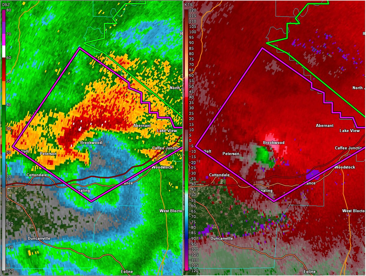
Radar confirmed tornado ON THE GROUND near Brookwood, moving NE toward Abernant. Stay in your safe place! #alwx
Posted on 3/17/21 at 3:22 pm to When in Rome
That storm heading to downtown Tuscaloosa is getting a hook on it. Lots of lightning around it too. It might drop one
Posted on 3/17/21 at 3:22 pm to Bobby OG Johnson
Severe Weather Statement
National Weather Service Birmingham AL
313 PM CDT Wed Mar 17 2021
ALC125-172045-
/O.CON.KBMX.TO.W.0018.000000T0000Z-210317T2045Z/
Tuscaloosa AL-
313 PM CDT Wed Mar 17 2021
...A TORNADO WARNING REMAINS IN EFFECT UNTIL 345 PM CDT FOR EAST
CENTRAL TUSCALOOSA COUNTY...
At 313 PM CDT, a confirmed tornado was located over Brookwood, or 8
miles east of Holt, moving northeast at 30 mph.
HAZARD...Damaging tornado and half dollar size hail.
SOURCE...Public confirmed tornado.
IMPACT...Flying debris will be dangerous to those caught without
shelter. Mobile homes will be damaged or destroyed. Damage
to roofs, windows, and vehicles will occur. Tree damage is
likely.
Locations impacted include...
Holt, Lake View, Brookwood, Coaling, Vance, Lake Wildwood, Abernant,
Deerlick Creek Campgrounds, Mercedes Benz Of Alabama, North Bibb,
Fleetwood, Bucksville, East Brookwood, Camp Horne B.S.A., Peterson,
Lake Harris, Caffee Junction, I 20 Rest Area Near Tuscaloosa, Cedar
Cove and Holt Lock And Dam.
PRECAUTIONARY/PREPAREDNESS ACTIONS...
To repeat, a tornado is on the ground. TAKE COVER NOW! Move to a
basement or an interior room on the lowest floor of a sturdy
building. Avoid windows. If you are outdoors, in a mobile home, or in
a vehicle, move to the closest substantial shelter and protect
yourself from flying debris.
&&
LAT...LON 3345 8735 3338 8723 3337 8723 3336 8720
3334 8720 3334 8718 3332 8718 3332 8716
3331 8716 3331 8713 3329 8712 3329 8709
3328 8709 3327 8706 3314 8732 3325 8751
TIME...MOT...LOC 2013Z 222DEG 27KT 3324 8736
TORNADO...OBSERVED
HAIL...1.25IN

Posted on 3/17/21 at 3:23 pm to deltaland
quote:
Hale County EMA:
-damage isolated to Moundville
-Multiple homes damaged. People were inside but no injuries.
-Down trees & power lines are blocking some roads
-A mobile home is in the street on Mink Slide Road
-Several businesses damaged in Moundville
@spann
@abc3340
Posted on 3/17/21 at 3:23 pm to When in Rome
I'm watching that cell just West of Tuscaloosa. It briefly looked like it was trying to develop some rotation but I don't think it's going to get there.
Posted on 3/17/21 at 3:24 pm to The Boat
Tornado warning around Jonesboro. Headed towards Eros, Calhoun, Claiborne, West Monroe

Posted on 3/17/21 at 3:24 pm to deltaland
quote:
That storm heading to downtown Tuscaloosa
Spann is on it now
Posted on 3/17/21 at 3:25 pm to sta4ever
What’s the update on the new one near Selma???
Posted on 3/17/21 at 3:25 pm to When in Rome
Tuscaloosa storm just went warned
Posted on 3/17/21 at 3:25 pm to deltaland
quote:
That storm heading to downtown Tuscaloosa is getting a hook on it. Lots of lightning around it too. It might drop one
With a TVS, mind you......unwarned. I don't get it.

Posted on 3/17/21 at 3:25 pm to paperwasp
That tornado warning was too fricking late. You don't wait when it's bearing down on a populated area like that.

Posted on 3/17/21 at 3:27 pm to GEAUXmedic
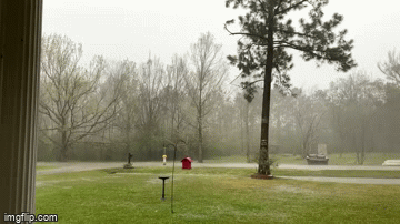
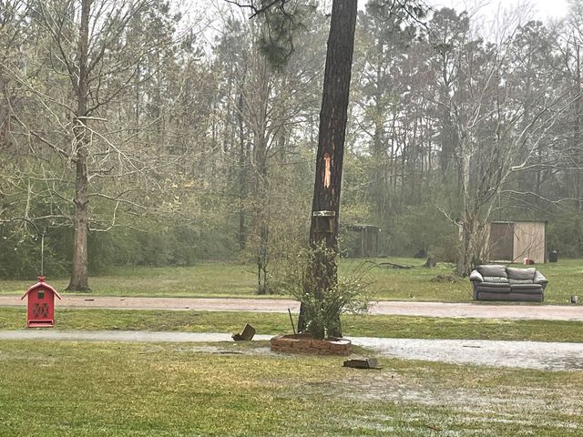
this baw in Deridder
Posted on 3/17/21 at 3:27 pm to LegendInMyMind
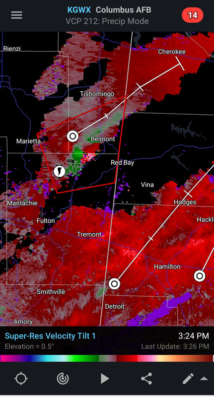
Northeast MS, south of Tishomingo.
Posted on 3/17/21 at 3:27 pm to GEAUXmedic
It was too late no doubt but lord have mercy idk how they keep up with all this
Posted on 3/17/21 at 3:27 pm to MorbidTheClown
quote:
this baw in Deridder
He must not have seen the video out of India....
Whelp....he needs to call a tree guy right now.
This post was edited on 3/17/21 at 3:29 pm

Posted on 3/17/21 at 3:27 pm to MorbidTheClown
Couch blown off the porch?

Posted on 3/17/21 at 3:28 pm to GEAUXmedic
This is why you don’t wait for sirens. Monitor your weather alerts on your phone or NOAA weather radio
Posted on 3/17/21 at 3:28 pm to MorbidTheClown
Posted on 3/17/21 at 3:29 pm to LegendInMyMind
Belmont is the farm I’m partnered in headquarters (we are spread out pretty far renting ground) 

 Page 45 of 64

Back to top