- My Forums
- Tiger Rant
- LSU Recruiting
- SEC Rant
- Saints Talk
- Pelicans Talk
- More Sports Board
- Fantasy Sports
- Golf Board
- Soccer Board
- O-T Lounge
- Tech Board
- Home/Garden Board
- Outdoor Board
- Health/Fitness Board
- Movie/TV Board
- Book Board
- Music Board
- Political Talk
- Money Talk
- Fark Board
- Gaming Board
- Travel Board
- Food/Drink Board
- Ticket Exchange
- TD Help Board
Customize My Forums- View All Forums
- Show Left Links
- Topic Sort Options
- Trending Topics
- Recent Topics
- Active Topics
Started By
Message
re: Severe Weather Moving East Today
Posted on 1/6/20 at 2:25 pm to LSUfanNkaty

Posted on 1/6/20 at 2:25 pm to LSUfanNkaty
Yes. Look at the alumni across the country for the schools I listed versus LSU’s fan base which aside from Louisiana residents are largely in Texas (Dallas, Houston) and other southern states nearby.
 0
0


Posted on 1/6/20 at 2:39 pm to Paul Allen
Well, Clemson fans will still have to travel too. When’s the last time your beloved Irish have won anything of significance?

Posted on 1/6/20 at 3:18 pm to red sox fan 13
quote:
When’s the last time your beloved Irish have won anything of significance?
HINT: It's been a while. This was their coach the last time they mattered.

This post was edited on 1/6/20 at 3:19 pm
Posted on 1/6/20 at 4:10 pm to Roll Tide Ravens
quote:
A Day 7 highlighted threat is very rare, particularly in January. That indicates, to me anyway, that they have confidence in the possibility of a significant severe weather threat, otherwise they would not even highlight it yet.
Been worried about severe in the south with this pattern about to set up. Cold in the west, warm east. Jet cuts across the country.

Posted on 1/6/20 at 4:37 pm to Duke
Not to mention a whole lot of rainfall over the Ohio River valley if the set up sticks around.

Posted on 1/6/20 at 4:41 pm to TDsngumbo
quote:
Not to mention a whole lot of rainfall over the Ohio River valley if the set up sticks around.
Is it too early for the annual "ORCS/Morganza gonna fail" thread?

Posted on 1/6/20 at 5:28 pm to rds dc
I’ve been waiting on something like this.
In NWLa, it’s been cooling off at night with no cloud cover but it’s been 65-70 during the afternoons. Been waiting on a cold front to hit during one of these warm afternoons. Apparently, we are going to have Gulf moisture as well.
In NWLa, it’s been cooling off at night with no cloud cover but it’s been 65-70 during the afternoons. Been waiting on a cold front to hit during one of these warm afternoons. Apparently, we are going to have Gulf moisture as well.
Posted on 1/6/20 at 5:52 pm to BallsEleven
quote:
Is it too early for the annual "ORCS/Morganza gonna fail" thread?
Never too early for that thread. It’s always very entertaining and full of expert hydrologists.
Posted on 1/7/20 at 7:42 am to rds dc
Updates from SPC & NWS Shreveport


Posted on 1/7/20 at 11:25 am to rds dc
I'd expect a small area for Moderate Risk to be posted by Friday

Posted on 1/7/20 at 1:39 pm to rds dc
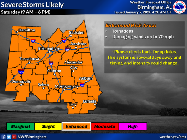
From NWS BMX
Posted on 1/7/20 at 2:22 pm to Cosmo
I hope Saturday at MSY will be ok. I’ll be working Aviation Weather METAR observations at MSY Wednesday thru Sunday.
This post was edited on 1/7/20 at 2:24 pm
Posted on 1/7/20 at 2:33 pm to rds dc
It’s snowing here in Northern Va.
Posted on 1/7/20 at 2:35 pm to Klingler7
So far this January (6 days) : Baton Rouge average temperature is + 4.0 F above normal and New Orleans mean temperature is +6.9 F above normal .
Above normal temperatures expected in Baton Rouge thru at least the 13th of January.
I would expect a moderate cool down to occur in later January to offset these above average temps. It’s rare to see a winter month with +6-9 F above normal for whole month. The upper level pattern will inevitably shift withl colder air building up in Canada and pushing south when ridging shifts to eastern pacific states.
This post was edited on 1/7/20 at 2:37 pm

Posted on 1/7/20 at 10:00 pm to Klingler7
This just seems serious. Still a few days out and confidence is still high.
From the SPC:
From the SPC:
quote:
A multi-day severe weather episode is expected Day 4-5/Fri-Sat from the Arklatex into the Deep South vicinity. An intense mid/upper trough over the Four Corners and northwest Mexico early on Friday will eject eastward into the southern Plains by 12z Saturday. At the surface, low pressure will develop over TX and shift east/northeast toward central AR by 12z Saturday. Ahead of the low, rich Gulf moisture will stream northward across eastern TX/OK and expand eastward across the lower MS Valley and Gulf Coast states through Saturday. 60s F dewpoints are forecast to extend as far north as the lower OH Valley by Saturday morning, with upper 60s to near 70s dewpoints over parts of the Arklatex on Friday into much of LA/MS/AL/GA on Saturday. This anomalously rich and broad warm sector will reside beneath a 50-70 kt southerly low level jet and 80+ kt southwesterly 500 mb jet streak. While some questions remain over how pristine the warm sector ahead of the surface low and cold front will remain, especially on Saturday, this kinematic and thermodynamic parameter-space will support severe thunderstorms capable of all severe hazards from the Arklatex into the TN Valley/Gulf Coast states Friday and Saturday. Mixed convective modes are anticipated given the strength of shear, with a QLCS likely developing ahead of the surface cold front. This will support damaging gusts and mesovortex tornado potential. Additionally, any semi-discrete convection that develops ahead of the QLCS will be in an environment capable of supporting supercells and tornadoes, especially from east TX through central MS/AL.

Posted on 1/7/20 at 10:15 pm to East Coast Band
I don't feel like posting a ton of images, but the models are definitely showing a high end event very consistently.
Posted on 1/7/20 at 10:18 pm to East Coast Band
Torcon?
Posted on 1/7/20 at 10:31 pm to GEAUXmedic
quote:
I don't feel like posting a ton of images
I only understand images.
Posted on 1/8/20 at 9:48 am to BallsEleven
quote:
Is it too early for the annual "ORCS/Morganza gonna fail" thread?
Yes. Those don’t come till April right after the tornado outbreak threads when snow melt and spring rains combine

 Page 3 of 51

Popular
Back to top