- My Forums
- Tiger Rant
- LSU Recruiting
- SEC Rant
- Saints Talk
- Pelicans Talk
- More Sports Board
- Fantasy Sports
- Golf Board
- Soccer Board
- O-T Lounge
- Tech Board
- Home/Garden Board
- Outdoor Board
- Health/Fitness Board
- Movie/TV Board
- Book Board
- Music Board
- Political Talk
- Money Talk
- Fark Board
- Gaming Board
- Travel Board
- Food/Drink Board
- Ticket Exchange
- TD Help Board
Customize My Forums- View All Forums
- Show Left Links
- Topic Sort Options
- Trending Topics
- Recent Topics
- Active Topics
Started By
Message
re: Severe Weather Moving East Today
Posted on 1/8/20 at 9:53 am to deltaland
Posted on 1/8/20 at 9:53 am to deltaland
PBS Newshour had the head of the BR/Nola river pilots association on last week talking about all the navigation problems since the high water. For as much as ole baw makes I expected him to dress better.
 2
2


Posted on 1/8/20 at 9:55 am to Jim Rockford
quote:
PBS Newshour had the head of the BR/Nola river pilots association on last week talking about all the navigation problems since the high water. For as much as ole baw makes I expected him to dress better.
There it is, the Morganza Thread has started within a severe weather thread.

Posted on 1/8/20 at 9:55 am to Jim Rockford
Forecast contest winner here. Tell me what y’all need to know.
Posted on 1/8/20 at 11:12 am to rds dc
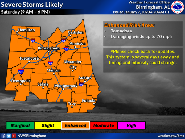
Enhanced risk extended southward to include all of south Louisiana
This post was edited on 1/8/20 at 11:14 am
Posted on 1/8/20 at 11:17 am to purple18


Posted on 1/8/20 at 11:20 am to slackster
quote:
A volatile weather pattern continues to be apparent for Friday from
eastern TX/OK into the lower MS Valley. An intense mid/upper
shortwave trough over the southern Rockies into northern Mexico will
intensify as it shifts east into the southern Plains through the end
of the period. Most guidance shows a 100+ kt 500 mb jet streak
spreading across eastern OK/TX after 00z, with a 60+ kt
south/southwesterly low level jet developing over the
Arklatex/Sabine River vicinity by 00z. Guidance varies some in the
development of a surface low, located somewhere from north TX to
northern OK Friday morning. The low will deepen as it shifts
east/northeast across AR to near the MO Bootheel vicinity by
Saturday morning.
While the evolution of the surface low remains a bit uncertain,
strong south/southeasterly low level flow ahead of the low and its
associated cold front, will bring rich Gulf moisture northward
across eastern OK/TX and the lower MS Valley. Upper 60s F to low 70s
F dewpoints over eastern and coastal TX will spread eastward across
LA/southern AR and into MS and southwest AL by 12z Saturday. Atop
this anomalously moist boundary layer, steep midlevel lapse rates
courtesy of an EML spreading east/northeast from the Mexican Plateau
will result in pockets of MLCAPE from 750-1500 J/kg from eastern TX
into LA and adjacent portions of AR/MS where stronger heating is
expected. Further north, where temperatures and dewpoints will be
lower, instability will quickly diminish to less than 500 J/kg into
the mid-MS Valley. Mixed convective mode is likely, with a QLCS
developing in the vicinity of the surface cold front by late
afternoon across OK/north TX. Intense shear will aid in damaging
wind potential and very moist low levels, combined with backed low
level flow/strong SRH, will support mesovortex development along the
line. The QLCS will develop east/northeast through the overnight
hours.
Additionally concerning is any convection that develops across the
warm sector ahead of the front/QLCS. Guidance continues to indicate
that more discrete warm sector development is possible, across parts
of eastern TX into LA. Supercells capable of all severe hazards,
some possibly significant, appear most probable across this area
from late afternoon into the overnight hours.


Posted on 1/8/20 at 11:28 am to slackster
Posted on 1/8/20 at 11:40 am to slackster
Seems to be setting up nicely. I predict we end up getting an area of moderate risk across eastern Ar, La, central Ms, and west Central Alabama

Posted on 1/8/20 at 11:46 am to deltaland
Torcon 6 for Shreveport, fwiw

Posted on 1/8/20 at 11:48 am to biggsc
quote:
Well... at least it's during the day. Night tornadoes are a hell of a lot scarier to me.
Posted on 1/8/20 at 11:52 am to rbWarEagle
The negative side to that is you get the hottest part of the day which leads to higher humidity and more energy for the storms to develop
Posted on 1/8/20 at 11:57 am to deltaland
quote:
The negative side to that is you get the hottest part of the day which leads to higher humidity and more energy for the storms to develop
I also feel like the "benefits" of day tornados are reduced as you go further east. Visibility becomes less useful due to the terrain, I'd think.
Posted on 1/8/20 at 12:00 pm to Pettifogger
quote:
I also feel like the "benefits" of day tornados are reduced as you go further east. Visibility becomes less useful due to the terrain, I'd think.
Thank gawd for these Auburn plains.
Posted on 1/8/20 at 12:05 pm to purple18
That's not all of south Louisiana.
Posted on 1/8/20 at 12:07 pm to deltaland
quote:
predict we end up getting an area of moderate risk across eastern Ar, La, central Ms, and west Central Alabama
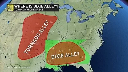
Those areas always get all the action. Tornado Alley's official "boundaries" should probably be updated to include these areas because it seems over the past 10 years or so many of the more intense tornadoes don't occur in Texas and the plains.
This post was edited on 1/8/20 at 12:08 pm

Posted on 1/8/20 at 12:07 pm to rbWarEagle
quote:
Night tornadoes are a hell of a lot scarier to me.
Really shouldn't be anymore.
With advanced radar,etc. You can better track a tornado on TV or your phone better than looking for one out the window
Posted on 1/8/20 at 12:08 pm to East Coast Band
quote:
Really shouldn't be anymore.
With advanced radar,etc. You can better track a tornado on TV or your phone better than looking for one out the window
Tracking them at night isn't the big problem I have with nighttime tornadoes. My problem is I can't sleep out of fear that if I do, I won't know one is heading my way and will be caught unprepared.
Posted on 1/8/20 at 12:18 pm to Pettifogger
quote:
I also feel like the "benefits" of day tornados are reduced as you go further east. Visibility becomes less useful due to the terrain, I'd think.
There's a reason most chasers hate to chase in the "jungle", can't see shite for all the trees.
Posted on 1/8/20 at 12:18 pm to TDsngumbo
quote:
Those areas always get all the action. Tornado Alley's official "boundaries" should probably be updated to include these areas because it seems over the past 10 years or so many of the more intense tornadoes don't occur in Texas and the plains.

 Page 4 of 51

Popular
Back to top