- My Forums
- Tiger Rant
- LSU Recruiting
- SEC Rant
- Saints Talk
- Pelicans Talk
- More Sports Board
- Fantasy Sports
- Golf Board
- Soccer Board
- O-T Lounge
- Tech Board
- Home/Garden Board
- Outdoor Board
- Health/Fitness Board
- Movie/TV Board
- Book Board
- Music Board
- Political Talk
- Money Talk
- Fark Board
- Gaming Board
- Travel Board
- Food/Drink Board
- Ticket Exchange
- TD Help Board
Customize My Forums- View All Forums
- Show Left Links
- Topic Sort Options
- Trending Topics
- Recent Topics
- Active Topics
Started By
Message
re: Severe Weather: May 19-20, 2025
Posted on 5/20/25 at 10:15 pm to HoLeInOnEr05
Posted on 5/20/25 at 10:15 pm to HoLeInOnEr05
quote:
You a Limestone County baw as well?
Maybe.
 1
1

Posted on 5/20/25 at 10:38 pm to Wishnitwas1998
quote:
Spann is as confused as I am that today wasn't a lot worse.
I'm going with that it's just been getting too warm consistently lately, summerlike, and we typically don't have severe tornadic days in the summer.
Maybe if this setup happened just a month ago....
Posted on 5/20/25 at 10:44 pm to East Coast Band
quote:
I'm going with that it's just been getting too warm consistently lately, summerlike, and we typically don't have severe tornadic days in the summer.
Maybe if this setup happened just a month ago....
It's always seemed to me that a pretty strong cold front is needed to trigger the really bad stuff. Along with some other factors.
The cool front behind this line probably isn't strong enough.
Temp drops in my area are predicted to only be about 10 degrees.
Posted on 5/20/25 at 11:26 pm to LegendInMyMind
quote:
Maybe
I got caught at Buccees when the thing hit. I only live 5 minutes from there and thought I could get diesel and get back home before the shite hit the fan.
Posted on 5/20/25 at 11:32 pm to HoLeInOnEr05
Did you get a brisket sammich?
Posted on 5/20/25 at 11:39 pm to HoLeInOnEr05
quote:
I got caught at Buccees when the thing hit. I only live 5 minutes from there and thought I could get diesel and get back home before the shite hit the fan.
Yeah, you were damn close. Glad it missed you and hope you didn't have any damage. Our lights blinked once or twice, but power stayed on. Barely had any rain from that storm or the one behind it. I watched it from just a couple miles away until a really close lightning strike ran me inside.
Posted on 5/20/25 at 11:46 pm to LegendInMyMind
We are in west Limestone and had 1.20” rain, wind max 50 mph, and lost power around 6 pm. Power came back on at 11 pm. God bless the Linemen of Athens Utilities. That was a bad arse system.
Posted on 5/20/25 at 11:52 pm to auggie
quote:
It's always seemed to me that a pretty strong cold front is needed to trigger the really bad stuff. Along with some other factors.
The cool front behind this line probably isn't strong enough.
Temp drops in my area are predicted to only be about 10 degrees.
There was some stuff going on with the midlevels that kind kept the ceiling a little lower on this one. Shear was also lacking a bit in the early part of today's setup. Once the LLJ ramped up into the evening those storms coming out of MS and into AL got a good boost. By then, though, it was a pretty messy storm mode. Thankfully, nothing had a whole lot of room to work and it was more of a whack-a-mole situation with tornadoes dropping here and there. There was a brief time with the lead storm when it was nearly out of Limestone county that things opened up to the south and the trailing storm lifted north a little that allowed it to maximize the LLJ and really wrap up. That kind coincided with the hail core collapsing and a big burst of RFD that eventually helped wrap that storm up as it moved into Madison. Then, the meso cranked, the hail core built again, and Huntsville got the worst of that core. That storm cycled again, and by the time it made it to NE Madison county it had changed structure completely. It and the trailing storm more or less merged, and it became an embedded supercell. It developed kind of stout rear inflow notch that would lead to another tornado, and actually two tornadoes at once as it started to exit Madison county.
This post was edited on 5/20/25 at 11:54 pm
Posted on 5/20/25 at 11:57 pm to George Dickel
quote:
We are in west Limestone and had 1.20” rain
We had right at 7/8", and all of it came in about 10 minutes or less from one of the blobs that popped up after the two main storms. It was rotating, too, but waited until it got through here before it started really spinning.
Posted on 5/21/25 at 9:58 am to auggie
quote:
I lived in the area for 45 years. The major tornadoes almost always hit the same places, while other areas never get touched.
HighCotton mentioned Anderson Hills. I knew a guy that lived there, that got his house totally demolished twice.
That's interesting, I live in PA, certainly not Tornado Alley, but the area directly around our house has had tornados a few times over the years. In 1998 a F2 and F4 tore through our neighbor's property over a three period, last August a F1 destroyed our neighbor's barn, and last month we had a funnel cloud pass over our house, but didn't touch down. We did lose some trees in that storm.
Edit: And we live in the mountains of PA, the highest point in PA is about 6 miles from our house.
This post was edited on 5/21/25 at 10:03 am
Posted on 5/21/25 at 10:13 am to LegendInMyMind
quote:
before it started really spinning
Most of that front seemed like it was rotating by the time it got close to Athens.

Posted on 5/21/25 at 10:20 am to tide06
Bad thunderstorm in Zachary right now with quarter size hail.
Posted on 5/21/25 at 11:06 am to tide06
For those interested, the London, Kentucky tornado from a few days ago that impacted a poster's neighborhood has been officially rated an EF4.
The complete survey report will be out later today.
Loading Twitter/X Embed...
If tweet fails to load, click here. The complete survey report will be out later today.
This post was edited on 5/21/25 at 11:23 am

Posted on 5/21/25 at 11:09 am to lsufan1971
quote:As of 7:00 AM today, rain chances in BR were down to 14% at the most this afternoon. I watered my lawn for 90 minutes
Bad thunderstorm in Zachary right now with quarter size hail.
Models needs to be better.

Posted on 5/21/25 at 11:23 am to bayoubengals88
quote:
Models needs to be better.
I've noticed this that last 5+ years. The day to day weather models are atrocious. But the severe, tropical, and winter weather models are amazing.

Posted on 5/21/25 at 11:35 am to lsufan1971
Took the dogs out to use the bathroom around 6 this morning. It was muggy as hell.
Cold front came through with a little rain since then. Feels like the temperature dropped 20 degrees. It's 71 degrees.
Cold front came through with a little rain since then. Feels like the temperature dropped 20 degrees. It's 71 degrees.
Posted on 5/21/25 at 12:16 pm to bayoubengals88
quote:
As of 7:00 AM today, rain chances in BR were down to 14% at the most this afternoon. I watered my lawn for 90 minutes
Models needs to be better.
12z (6am) HRRR valid at 1pm:
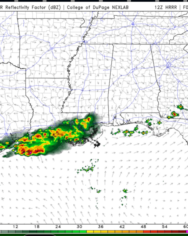
12z (6am) NAM valid at 1pm:
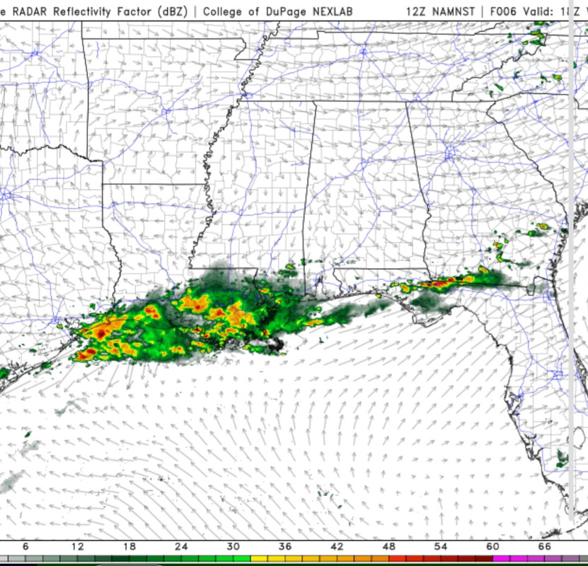
Any app that gives you hourly rain percentages will be varying degrees of shite. Learn to use actual models for yourself.
Posted on 5/21/25 at 1:59 pm to LegendInMyMind
The monster tornado that narrowly missed the small town of Plevna, Kansas (population of 84) was rated an EF3. It was almost certainly a violent tornado, but because it thankfully missed most of the small towns in the area it didn't produce that type of damage. It was a true wedge tornado that was likely close to 1.5 miles or wider at points of its lifespan. The survey puts its width at a mile wide, but is again limited to observable damage.
Loading Twitter/X Embed...
If tweet fails to load, click here.Posted on 5/21/25 at 10:26 pm to HoLeInOnEr05
NWS Huntsville has finished the preliminary ratings for the first of the Limestone and Madison county tornadoes.
The one Reed drove into was rated a 125mph EF2. So, not really the 200mph monster that Reed made it out to be. No injuries or fatalities on any of these, thank goodness.
I saw some of the damage today and talked to a girl at a gas station where a bunch of chasers had congregated. She said multiple chasers got pulled over by police and were given tickets for driving like idiots. I saw one of those for myself yesterday as the storms were still in progress. They got pulled over just down the road from us.
Loading Twitter/X Embed...
If tweet fails to load, click here. The one Reed drove into was rated a 125mph EF2. So, not really the 200mph monster that Reed made it out to be. No injuries or fatalities on any of these, thank goodness.
I saw some of the damage today and talked to a girl at a gas station where a bunch of chasers had congregated. She said multiple chasers got pulled over by police and were given tickets for driving like idiots. I saw one of those for myself yesterday as the storms were still in progress. They got pulled over just down the road from us.

 Page 16 of 16


Back to top