- My Forums
- Tiger Rant
- LSU Recruiting
- SEC Rant
- Saints Talk
- Pelicans Talk
- More Sports Board
- Fantasy Sports
- Golf Board
- Soccer Board
- O-T Lounge
- Tech Board
- Home/Garden Board
- Outdoor Board
- Health/Fitness Board
- Movie/TV Board
- Book Board
- Music Board
- Political Talk
- Money Talk
- Fark Board
- Gaming Board
- Travel Board
- Food/Drink Board
- Ticket Exchange
- TD Help Board
Customize My Forums- View All Forums
- Show Left Links
- Topic Sort Options
- Trending Topics
- Recent Topics
- Active Topics
Started By
Message

Severe Weather - Today - LA, MS, AL, NW FL
Posted on 4/16/19 at 3:30 pm
Posted on 4/16/19 at 3:30 pm
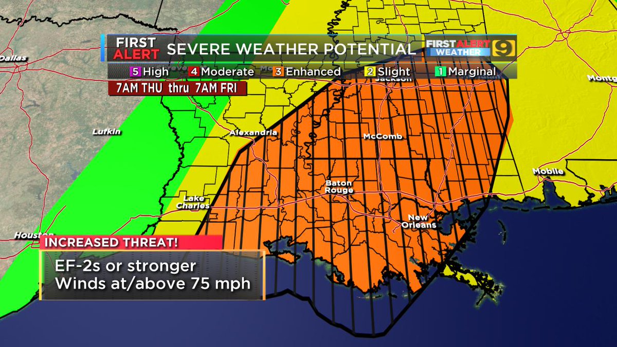
Images and discussion updated Thu 4:30 PM...
SPC AC 181922
Day 1 Convective Outlook
NWS Storm Prediction Center Norman OK
0222 PM CDT Thu Apr 18 2019
Valid 182000Z - 191200Z
...THERE IS AN ENHANCED RISK OF SEVERE THUNDERSTORMS OVER SOUTHEAST
LOUISIANA...MUCH OF MISSISSIPPI AND ALABAMA...AND THE FLORIDA
PANHANDLE...
...SUMMARY...
Several tornadoes (a few significant) and scattered to widespread
damaging winds are possible through tonight across the Lower
Mississippi Valley and central Gulf Coast States.
...LA/MS/AL...
A line of thunderstorms continues to consolidate and become better
organized from southeast LA into central MS as the large-scale
pattern continues to evolve favorably. Currently, a batch of warm
advection thunderstorms is lifting northward across southeast LA and
southern MS, intersecting the main line west of Jackson, MS. These
storms are on the leading edge of a surge in low-level theta-e from
the south, and in a region of pressure falls near the surface low.
The DGX VWP shows increasing SRH ahead of the line. Large scale
lift, moisture content and low-level shear will increase through the
afternoon, with the strongest instability across the southern half
of MS, southeast LA, and into western AL later today. Therefore, a
threat of QLCS-type severe wind gusts and tornadoes is likely to
increase over the next several hours.

 >
>


SPC AC 181922
Day 1 Convective Outlook
NWS Storm Prediction Center Norman OK
0222 PM CDT Thu Apr 18 2019
Valid 182000Z - 191200Z
...THERE IS AN ENHANCED RISK OF SEVERE THUNDERSTORMS OVER SOUTHEAST
LOUISIANA...MUCH OF MISSISSIPPI AND ALABAMA...AND THE FLORIDA
PANHANDLE...
...SUMMARY...
Several tornadoes (a few significant) and scattered to widespread
damaging winds are possible through tonight across the Lower
Mississippi Valley and central Gulf Coast States.
...LA/MS/AL...
A line of thunderstorms continues to consolidate and become better
organized from southeast LA into central MS as the large-scale
pattern continues to evolve favorably. Currently, a batch of warm
advection thunderstorms is lifting northward across southeast LA and
southern MS, intersecting the main line west of Jackson, MS. These
storms are on the leading edge of a surge in low-level theta-e from
the south, and in a region of pressure falls near the surface low.
The DGX VWP shows increasing SRH ahead of the line. Large scale
lift, moisture content and low-level shear will increase through the
afternoon, with the strongest instability across the southern half
of MS, southeast LA, and into western AL later today. Therefore, a
threat of QLCS-type severe wind gusts and tornadoes is likely to
increase over the next several hours.
> This post was edited on 4/18/19 at 4:36 pm
 34
34


Posted on 4/16/19 at 3:31 pm to NorthEndZone

Posted on 4/16/19 at 3:33 pm to NorthEndZone
NAM soundings look legit. The fact that the SPC is mentioning "strong tornadoes" already has my ears perked up. Let's wait and see.
Posted on 4/16/19 at 3:33 pm to NorthEndZone
Of course it doesn't look good. We're a couple of days out. This is when they hype it.
Posted on 4/16/19 at 3:34 pm to NorthEndZone
what is your question?

Posted on 4/16/19 at 3:35 pm to OysterPoBoy
Im driving east on Thursday evening, hopefully it will be gone by then

Posted on 4/16/19 at 3:35 pm to J Murdah
this thread is for weather guru's only
Posted on 4/16/19 at 3:37 pm to Ed Osteen
The OT hates actual meteorologists, but praise amateur weathermen, right?

Posted on 4/16/19 at 3:40 pm to NorthEndZone
Not worried about La right now trying to cover my arse tm in a DFW. We have a torcon of 5
Posted on 4/16/19 at 3:41 pm to 50_Tiger
quote:
torcon
Posted on 4/16/19 at 3:42 pm to NorthEndZone
April doing April things huh.
Wednesday afternoon for Oklahoma/Texas is more of a hail story than tornadoes (but they're possible). Rush hour and into the evening is the target time for Dallas area. The biggest concern being giant hail. I'm sure DFW area is sick of seeing that.
Thursday for SELA into Southern Mississippi has a greater tornado risk, especially for cells in front of the main developing line. It'll eventually line out and have wind/tornado risk in bowing segments of the line. Early afternoon into the evening being the expected timing.
Posted on 4/16/19 at 3:43 pm to Lsuhoohoo
Unusual to see the enhanced area focused so far south. Looks like it will be rough here in BR but hopefully this is another case of it not being as bad as feared.
Posted on 4/16/19 at 3:43 pm to OysterPoBoy
It's a vicious circle by now with the warnings/outlooks. The NWS doesn't obviously know exactly what/when something will happen, but they have no choice but to at least try and make a prediction to hopefully warn the public about what they could be facing.
Unfortunately, every time a storm system doesn't live up to the "hype", a lot of the very people they are trying to protect wind up just ignoring future warnings, because they feel like they aren't ever accurate.
Unfortunately, every time a storm system doesn't live up to the "hype", a lot of the very people they are trying to protect wind up just ignoring future warnings, because they feel like they aren't ever accurate.
Posted on 4/16/19 at 3:44 pm to Ed Osteen
quote:
this thread is for weather guru's only
Looks like we’re all here
Posted on 4/16/19 at 3:45 pm to J Murdah
Posted on 4/16/19 at 3:49 pm to BigB0882
What's even more odd is that they did a day 3 upgrade in the middle of the day, that almost never happens.
Posted on 4/16/19 at 3:52 pm to GEAUXmedic
quote:
What's even more odd is that they did a day 3 upgrade in the middle of the day, that almost never happens.
The question this morning was one of timing, and it seems like they've resolved that enough to call the zone of best parameters thanks to daytime heating.

Posted on 4/16/19 at 3:53 pm to GEAUXmedic
Gonna be a bumpy ride, baws.
This post was edited on 4/16/19 at 3:54 pm
Posted on 4/16/19 at 4:08 pm to Duke
quote:
The question this morning was one of timing, and it seems like they've resolved that enough to call the zone of best parameters thanks to daytime heating.
That does make sense looking back to how iffy they were.
Posted on 4/16/19 at 4:38 pm to NorthEndZone
RiP

 Page 1 of 69

Popular
Back to top