- My Forums
- Tiger Rant
- LSU Recruiting
- SEC Rant
- Saints Talk
- Pelicans Talk
- More Sports Board
- Fantasy Sports
- Golf Board
- Soccer Board
- O-T Lounge
- Tech Board
- Home/Garden Board
- Outdoor Board
- Health/Fitness Board
- Movie/TV Board
- Book Board
- Music Board
- Political Talk
- Money Talk
- Fark Board
- Gaming Board
- Travel Board
- Food/Drink Board
- Ticket Exchange
- TD Help Board
Customize My Forums- View All Forums
- Show Left Links
- Topic Sort Options
- Trending Topics
- Recent Topics
- Active Topics
Started By
Message
 1
1

Posted on 9/15/20 at 12:40 pm to weadjust
quote:
Gulf Bay Road, Orange Beach… photo from Mallori Entrekin

Posted on 9/15/20 at 12:42 pm to lsupride87
quote:
Any updates on the Caswell/Bayou St. John area of Canal rd?
I got a shitty video a little bit ago and the water had come up a bit but it wasn’t too much higher. Their pier is toast I’m sure.
I’ll call him in a sec.

Posted on 9/15/20 at 12:42 pm to LegendInMyMind
Yeah you can have a f-5 tornado rolling through a gigantic hay field at night and no debris ball. Only thing that would be showing up is maybe hail on the radar. Too many idiots. Not enough intelligence and trust in professionals. This isn't unique to one industry either.
Posted on 9/15/20 at 12:43 pm to Roll Tide Ravens
You know the storm is a nothing burger when TWC starts their reality show programming.
This post was edited on 9/15/20 at 12:43 pm
Posted on 9/15/20 at 12:43 pm to dukke v
Duke nailed it.......
Dukke V PeeJ whiffed....
quote:
It's going to intensity. I think upper Cat 2 is the ceiling at this point. Late track shear and needing to spend some time on organization put a lid on high end potential.
Dukke V PeeJ whiffed....
quote:
No. They are saying a Tuesday landfall... not enough time to intensify. It may reach hurricane strength, but will not get to a cat 2. Even though the weather channel is hoping it will.....

Posted on 9/15/20 at 12:44 pm to Redbone
Tell me what was wrong with my post...... it was kicking arse toward LA at 13 MPH and was getting stronger. It started getting weaker and slowed down to a crawl plus a front is coming through that will pick it up and take it to the NE..... again.... SPOT ON.
LA got lucky with this storm.....
LA got lucky with this storm.....
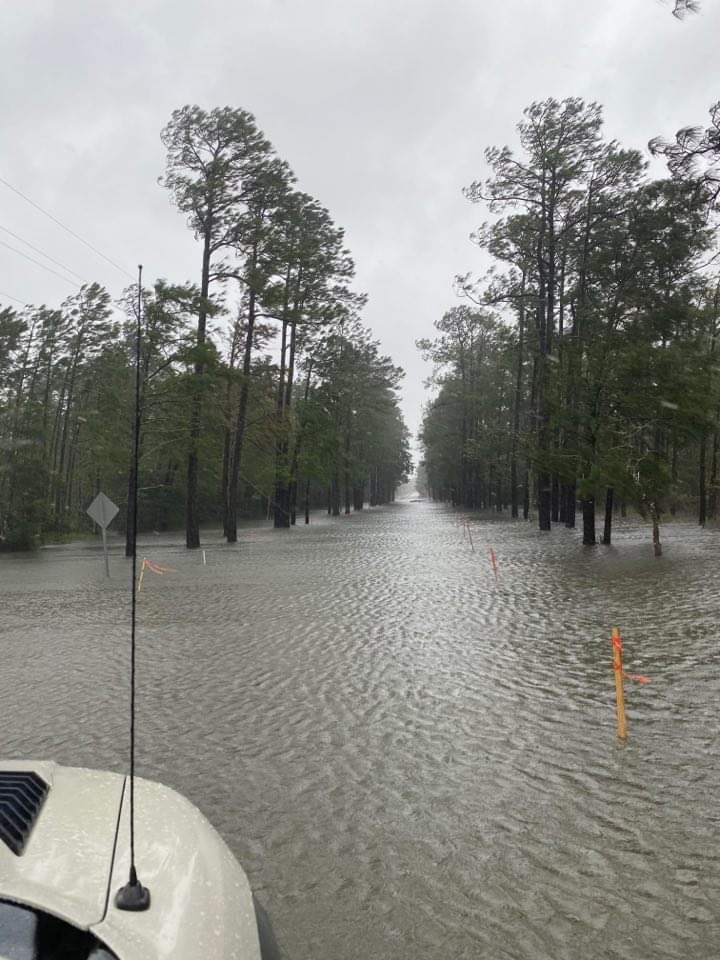
Posted on 9/15/20 at 12:45 pm to Bobby OG Johnson
quote:
Ono Island... photo from Jeff Jacobs. Peak wind gust so far at that location is 62 mph


Posted on 9/15/20 at 12:47 pm to tilco
quote:Thanks
I got a shitty video a little bit ago and the water had come up a bit but it wasn’t too much higher. Their pier is toast I’m sure.
I’ll call him in a sec.
Posted on 9/15/20 at 12:51 pm to lsupride87
80 mph at 1 pm, now that's getting close to reality.
Radar is showing some modest velocity increases on that north end and they generally support 80 mph max. This recon pass coming up will confirm if the storm is starting to strengthen some. There's not a lot of room for Sally to significantly stronger but short range modeling suggests it will a little. The increased outflow suggests the same.
Plus the IR showing it rotating that hot tower around and the center has gotten it's self pretty fixed in the middle of the convection. So organization appears to be improving but upwelling and slowly increasing shear should limit this trend.
Posted on 9/15/20 at 12:53 pm to dukke v
quote:You said to prove you wrong. That's a shitty thing to say since you offered no proof you were right.
Tell me what was wrong with my post......
Onus is on you. If you want someone to prove you wrong then YOU must give them evidence you OPINION was right.
See how that works?
Posted on 9/15/20 at 12:54 pm to Redbone
Read my post..... it was spot on as far as what has happened. 

Posted on 9/15/20 at 12:55 pm to dukke v
PEEJ, you are on a real hot streak ever since the laker/rocket series. god speed you glorious son of a bitch
Posted on 9/15/20 at 12:56 pm to WestCoastAg
Posted on 9/15/20 at 12:57 pm to dukke v
quote:
it was spot on as far as what has happened.
So now you're making predictions after the fact?
Posted on 9/15/20 at 12:59 pm to Roll Tide Ravens
quote:TWC would give their left nut for anything to hit NO.....then they can talk non-stop about levees, storm surge, flooding, below sea-level, 9th Ward, Katrina, etc.
I’m puzzled at how TWC has people in freaking New Orleans but apparently not on the Alabama Gulf Coast where the biggest impacts are.


Posted on 9/15/20 at 1:00 pm to tilco
its go time here from midtown.
my street got flooded from some random thunder storm last year within minutes.
not hanging around for the bullshite thats gonna be dumped on us
my street got flooded from some random thunder storm last year within minutes.
not hanging around for the bullshite thats gonna be dumped on us
Posted on 9/15/20 at 1:01 pm to RT1941
Last recon pass has it moving a little NE. Due south of Mobile Bay.
Radar seems to agree.
Radar seems to agree.
Posted on 9/15/20 at 1:02 pm to Bobby OG Johnson
Those pictures are from only a 2.5 to 3 foot water rise so far. When the actual surge comes in, it will be MUCH worse than that.

 Page 197 of 298

Popular
Back to top