- My Forums
- Tiger Rant
- LSU Recruiting
- SEC Rant
- Saints Talk
- Pelicans Talk
- More Sports Board
- Fantasy Sports
- Golf Board
- Soccer Board
- O-T Lounge
- Tech Board
- Home/Garden Board
- Outdoor Board
- Health/Fitness Board
- Movie/TV Board
- Book Board
- Music Board
- Political Talk
- Money Talk
- Fark Board
- Gaming Board
- Travel Board
- Food/Drink Board
- Ticket Exchange
- TD Help Board
Customize My Forums- View All Forums
- Show Left Links
- Topic Sort Options
- Trending Topics
- Recent Topics
- Active Topics
Started By
Message
re: Remnants of Arthur - Avoyelles Parish Ongoing Flash Flood Emergency
Posted on 6/17/26 at 4:36 pm to tigafan4life
Posted on 6/17/26 at 4:36 pm to tigafan4life
quote:
So the newest update got this thing staying in Texas or the track doesn't matter cuz it's so discombobulated that we still gonna get lots of rain in BR?
The precipitation is well east of the storm's center
SE LA & Mississippi gonna get rained on
 0
0


Posted on 6/17/26 at 4:36 pm to Bobby OG Johnson
That's not even facing the right way to be a northern hemisphere hurricane, right? Did they mirror a stock image or is that a southern hemisphere storm? 

Posted on 6/17/26 at 4:40 pm to tigafan4life
 >
>Posted on 6/17/26 at 4:43 pm to tigafan4life
quote:
So the newest update got this thing staying in Texas
Arthur is definitely not in Texas anymore
The center of the storm dictates his location and possible path and that's up in the air at the moment.
Posted on 6/17/26 at 4:44 pm to trussthetruzz
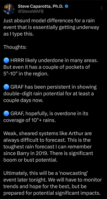
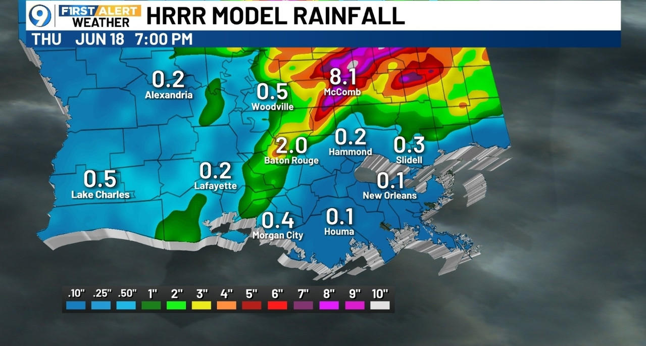
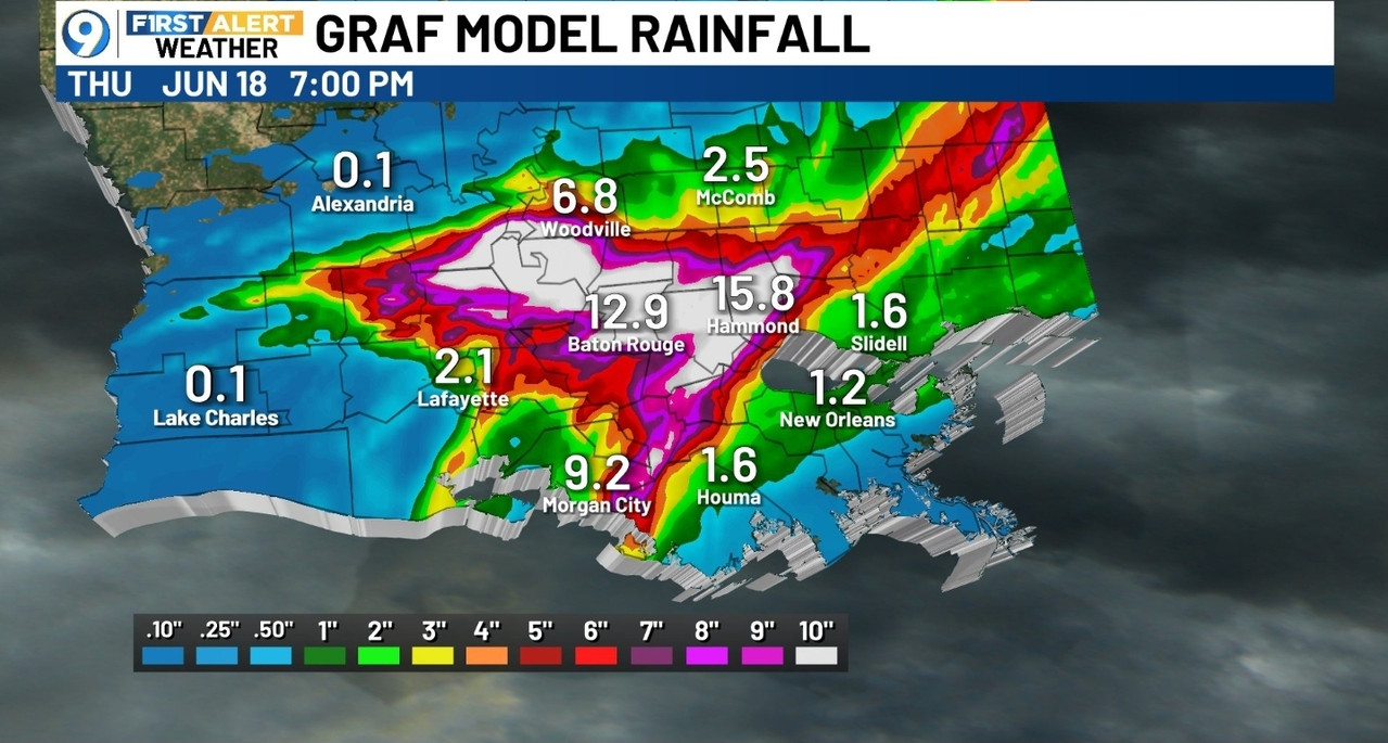
2.0 to 12.9??!? How can two predictions be so far off?
Posted on 6/17/26 at 4:44 pm to trussthetruzz
so Hammond will get anywhere from a trace amount of rain to 16” .
Posted on 6/17/26 at 4:45 pm to cgrand
Sooo what are my chances of my flight from Dallas to BTR making it at 11am tomorrow
Posted on 6/17/26 at 4:46 pm to tigafan4life
quote:
2.0 to 12.9??!? How can two predictions be so far off?
I believe the HRRR uses data from radar to base some of its predictions on. I dont think its getting enough radar data because the bulk of convection is offshore almost too far away for radar to see.
All this is to say, that model probably isnt getting the full picture.

Posted on 6/17/26 at 4:46 pm to Ingeniero
quote:
That's not even facing the right way to be a northern hemisphere hurricane, right? Did they mirror a stock image or is that a southern hemisphere storm?
This is from an AI in regards the image they used so take that for what it is worth
quote:
Hurricane Isabel (2003), likely captured from the International Space Station (ISS).
alamy.com
The dramatic stock photo ABC used—with a well-defined, clear eye and symmetric swirling cloud bands—is a classic NASA/SPL (Science Photo Library) image commonly licensed through Getty Images. It matches known photos of Hurricane Isabel, a powerful Category 5 storm that struck the U.S. East Coast in mid-September 2003.
alamy.com
Key details: One prominent version was taken from the ISS around September 13, 2003 (before landfall on September 18). It shows Isabel at or near peak intensity with a distinct eye.
alamy.com
Posted on 6/17/26 at 4:49 pm to gaetti15
So who we supposed to believe? I wanna believe the 2 inch one but I feel that would be wrong.

Posted on 6/17/26 at 4:51 pm to tigafan4life
I love how the bulk of this shite always happens in the middle of the fricking night
Posted on 6/17/26 at 4:53 pm to ThePoo
Never fails. Can't see shite at night and tornadoes can pop off too. It really is inconvenient
This post was edited on 6/17/26 at 4:53 pm
Posted on 6/17/26 at 4:57 pm to tigafan4life
quote:
So who we supposed to believe? I wanna believe the 2 inch one but I feel that would be wrong.
BOHICA
Posted on 6/17/26 at 5:11 pm to Disco Ball
Almost looks like they will have Two Lows...original Low dissipating inland Texas. The other(mid level) Low still over the water moving into SW La late tonight ; early morning .
This post was edited on 6/17/26 at 5:21 pm
Posted on 6/17/26 at 5:13 pm to cgrand
quote:
so Hammond will get anywhere from a trace amount of rain to 16”
You should plan to, at minimum, not wear suede outside tomorrow, but also get the ark out of storage just in case.
100+ years of meteorological science; state of the art radars, graphs, models; ever more robust AI...and the best we can ballpark is you'll get anywhere from a small puddle in your driveway to more than foot of rain
Posted on 6/17/26 at 5:25 pm to rds dc
Hwy 82 from Holly Beach to the Johnson's Bayou will have to be moved further inland once again, like the several times since at least 1970
Posted on 6/17/26 at 5:26 pm to ILurkThereforeIAm
Thanks to poster Ilurk (page 11, first post this thread)
for handy links to North Shore river gages.
reposting link for convenience
North shore river watch
Wafb has one for rivers in western Florida Parishes
WAFB Baton Rouge area river stages links
for handy links to North Shore river gages.
reposting link for convenience
North shore river watch
Wafb has one for rivers in western Florida Parishes
WAFB Baton Rouge area river stages links

Posted on 6/17/26 at 5:30 pm to CitizenK
It just got shut down about an hour ago.
This post was edited on 6/17/26 at 5:31 pm
Posted on 6/17/26 at 5:35 pm to trussthetruzz
Gonna be an interesting drive to work tomorrow.
Posted on 6/17/26 at 5:40 pm to LSURoss
quote:
It just got shut down about an hour ago.
We'll see if it needs to be completely rebuilt further inland just like several times before. The Dutch engineered armored shore didn't help in the 1970's That got torn up too along with the roadway.

 Page 12 of 27

Popular
Back to top