- My Forums
- Tiger Rant
- LSU Recruiting
- SEC Rant
- Saints Talk
- Pelicans Talk
- More Sports Board
- Fantasy Sports
- Golf Board
- Soccer Board
- O-T Lounge
- Tech Board
- Home/Garden Board
- Outdoor Board
- Health/Fitness Board
- Movie/TV Board
- Book Board
- Music Board
- Political Talk
- Money Talk
- Fark Board
- Gaming Board
- Travel Board
- Food/Drink Board
- Ticket Exchange
- TD Help Board
Customize My Forums- View All Forums
- Show Left Links
- Topic Sort Options
- Trending Topics
- Recent Topics
- Active Topics
Started By
Message
 0
0

Posted on 3/20/22 at 11:09 am to tarzana
quote:
Meteorologist Nick Mikulas
Model timing has shifted a bit, but our severe threat might end up being more robust because of this. A significant, areawide severe threat will overspread the area starting late Monday night or early Tuesday, here’s how I see it unfolding.
SPC has introduced a moderate, level 4 of 5 risk for severe storms over part of the area in their day 3 forecast, with most of the area at least in a level 3 of 5 risk between late Monday night and Tuesday. A day 3 moderate risk is quite rare, and has been issued because of pretty much maxed out severe parameters. These even look more impressive because the system has slowed a bit, meaning the peak time for action is now Tuesday morning into Tuesday afternoon. There could still be some isolated severe storms, especially northwest of a Leesville to Winnfield line Monday night, but I think the nighttime hours probably stay fairly tame east of that line. It’s not an exact representation, but a close enough forecast. Don’t draw a line and think that if you are two miles east of it that it’s impossible to see a storm Monday night. As these storms develop to our northwest, the main upper level feature will slow down as the jet stream aligns with the approaching front. This means training thunderstorms, and flooding rain. The most likely area, for the worst of this will be across northwest Louisiana, where a stripe of 4-8 inches of rain, centered near Shreveport looks likely.
Tuesday morning, storms will be blasting away to our northwest, but will start to inch this way. The big question is, will we get supercells ahead of the main line? If we do, all modes of severe weather will be likely with any of these storms, and there is a potential for strong tornadoes. Once the main line arrives by early afternoon, it will bring strong wind, and the threat for isolated tornadoes embedded within the line, but the most significant severe threat will come with any cells that can develop ahead of that solid line of storms that’ll move through. The most likely time for supercells will be from 10:00 AM until 4:00 PM. The earlier potential will be near the Texas border, and the later afternoon storms will be near the Mississippi River. The squall line will be just behind this, and should move through the area between noon and 6:00 PM. Locally, I expect 2-4 inches of rain. I think the worst of the flooding rain stays to our northwest, but it’s something to watch. WPC has most of the area in a slight to moderate risk for excessive rainfall, so that’ll be another layer to deal with in this system. Behind the front, we go back to pleasant weather, and don’t have any weather issues to deal with for at least 4-5 days.
I’m bringing out all the scary words in this one. Strong tornadoes, significant threat, moderate risk, and maxed out severe parameters all show up in this forecast. There are always failure options when it comes to severe weather. Cooler shelf waters in the Gulf could temper things a bit down south. Too many storms because of the strong upper level feature could interrupt the potentially volatile environment for severe weather. But you really need to be prepared for the chance that things come together, and we have a severe weather outbreak in our area. Severe parameters like this are rare, and we haven’t seen a high end threat like this in a while. I think there will be tornadoes in the state, and likely a couple in our area. It’s impossible to say exactly where, but I’ll be on top of things as this all unfolds. The “good” news is that this should be mainly a daytime threat in our area, so most will be awake, with the option to act quickly if needed. I’ll be watching incredibly closely, and keep you as informed as I am.


Posted on 3/20/22 at 11:12 am to tarzana
Pay attention to the difference in wording and tone compared to last week's threat. This one is entirely different.
When comparing discussions, particularly at the Day 3 mark, note the change from "could" and "may" to "will". After reading enough SPC discussions, their shift in tone becomes pretty evident. You can just tell when they feel that a setup has a big bust potential (last week), this isn't one of those discussions.
Do not let last week's bust influence your decision making for this setup. This has High Risk potential, and that area doesn't see too many High Risk days.
quote:
SPC AC 200757
Day 3 Convective Outlook CORR 1 NWS Storm Prediction Center Norman OK 0257 AM CDT Sun Mar 20 2022
Valid 221200Z - 231200Z
...THERE IS A MODERATE RISK OF SEVERE THUNDERSTORMS FROM PORTIONS OF SOUTHERN LOUISIANA INTO SOUTHERN MISSISSIPPI...
CORRECTED MRGL RISK LINE
...SUMMARY... A substantial severe weather event -- including potential for significant tornadoes -- remains evident over the Lower Mississippi Valley/central Gulf Coast region Tuesday.
...Synopsis... A upper trough and expansive area of highly amplified cyclonic flow will shift gradually eastward across the central U.S. Tuesday, as a closed low likely evolves over the Mid Missouri Valley area with time.
At the surface, a low is forecast to move across the Missouri vicinity through the day, with a trailing cold front forecast to reach the Mississippi Delta region during the afternoon. Late in the period, the low should reside over the Illinois vicinity, with the cold front extend southward across Kentucky/Tennessee/Alabama to the Florida Panhandle.
...Lower Mississippi/central Gulf Coast States... A regional severe-weather outbreak -- including potential for several tornadoes (a few potentially significant) remains evident for Tuesday. Severe storms -- including tornado risk -- will likely be ongoing at the start of the period across the Sabine River Valley area of east Texas/western Louisiana, as a surface cold front moves steadily eastward.
As southerly flow ahead of the front continues to advect high theta-e air northward from the Gulf, limited heating will allow destabilization to occur through the morning and into the afternoon. At this time, it appears that in addition to storms occurring ahead of the advancing front, pre-frontal cellular convection will also evolve through late morning/afternoon. With strong low-level southerly flow (50 to 70 kt at 850mb) in place, and 70 to 90 kt mid-level westerlies overspreading the region, shear very favorable for strong updraft rotation and low-level mesocyclones will exist. As such, potential for strong tornadoes will exist with the evolving supercell storms ahead of the front.Additionally, tornadoes (along with damaging winds and hail) will be likely with storms shifting eastward in tandem with the cold front.
Into the evening and overnight, severe risk -- including potential for tornadoes and damaging winds -- will continue. While diminishing somewhat later in the period, threat will likely spread across southern Alabama and into the Florida Panhandle.
..Goss.. 03/20/2022
CLICK TO GET WUUS03 PTSDY3 PRODUCT
NOTE: THE NEXT DAY 3 OUTLOOK IS SCHEDULED BY 0730Z
When comparing discussions, particularly at the Day 3 mark, note the change from "could" and "may" to "will". After reading enough SPC discussions, their shift in tone becomes pretty evident. You can just tell when they feel that a setup has a big bust potential (last week), this isn't one of those discussions.
Do not let last week's bust influence your decision making for this setup. This has High Risk potential, and that area doesn't see too many High Risk days.
This post was edited on 3/20/22 at 11:14 am

Posted on 3/20/22 at 11:17 am to LegendInMyMind
Let’s hope the forecaster writing that discussion doesn’t also post on this site because if so, we can write off any hyperbolic language 
Edit: I’d like to apologize for my shitty skeptical posts in advance of this event. I’m just over severe weather threats being advertised as so major and significant only to have all the storms morph into a straight line of storms by the time it gets here. All we end up with is an inch or so of rain along with pea to marble sized hail in spots.
Edit: I’d like to apologize for my shitty skeptical posts in advance of this event. I’m just over severe weather threats being advertised as so major and significant only to have all the storms morph into a straight line of storms by the time it gets here. All we end up with is an inch or so of rain along with pea to marble sized hail in spots.
This post was edited on 3/20/22 at 11:21 am
Posted on 3/20/22 at 11:20 am to LegendInMyMind
Still got work to do on a post about the set up, but yeah this isnt last week. The return flow will be in place for a day and it should be in the afternoon so daytime heating.
Boundary layer will be mixed. Storm mode is the main limiter at this point. We want a mess of storms competing with one another. Individual cells will be big trouble and a QLCS will be rocking, though that at least cuts the top end off the tornado threat.
Should get a bunch of forcing with big time upper divergence, enough to form up a surface low roughly in northern Louisiana. Ramp up the low level winds that way.
Still expect southern Miss to get fricked more than Louisiana but you cant ignore the abundant severe parameters that will be over all of Louisiana.
Posted on 3/20/22 at 11:40 am to Duke
This a daylight event for SELA?
Posted on 3/20/22 at 11:44 am to CypressTrout10
Yes.
That's part of the higher risk, warmer at the surface.
That's part of the higher risk, warmer at the surface.
Posted on 3/20/22 at 11:44 am to CypressTrout10
quote:
This a daylight event for SELA?
Yes.

Posted on 3/20/22 at 11:47 am to LegendInMyMind

Posted on 3/20/22 at 11:50 am to tarzana
quote:
That's a mean motor scooter, and a bad go-getter. Houston north suburban is under the gun Monday night--early Tuesday morning, and they're talking bout catastrophic flooding, hail, even a major tornado (EF-3 or bigger--very rare in this area).
Who’s talking about catastrophic flooding? The Space City Weather guys certainly are not.
Posted on 3/20/22 at 11:51 am to Duke
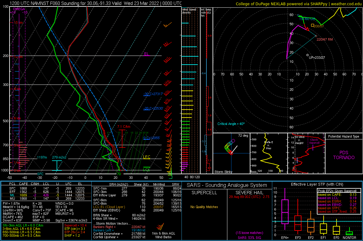
First one I pulled from the last frame of NAMnst on the leading edge of the broken line:
Northwest of Baton Rouge
Northwest of Baton Rouge
Posted on 3/20/22 at 11:57 am to LegendInMyMind

Posted on 3/20/22 at 11:58 am to LegendInMyMind
Those low level lapse rates are pretty damn steep (for the region, not for the world).
Posted on 3/20/22 at 12:00 pm to TDsngumbo
A sounding can tell you the parameters you will likely be dealing with at that particular moment in time. It basically means that if a surface-based storm were to get going it would put down a tornado due to those parameters. In this instance, that would be a PDS (Particularly Dangerous Situation) tornado.
Of course, this is a model and it isn't the end all be all. The take-away is that this was the first sounding I pulled for this event. It usually takes some hunting to find a PDS sounding.
Of course, this is a model and it isn't the end all be all. The take-away is that this was the first sounding I pulled for this event. It usually takes some hunting to find a PDS sounding.
Posted on 3/20/22 at 12:11 pm to LegendInMyMind
Legend thoughts and prayers baw.
Posted on 3/20/22 at 12:13 pm to LegendInMyMind
condolences to you are yours - be safe.
I will be driving from Rome GA back to Birmingham Wed am should make for a fun ride
I will be driving from Rome GA back to Birmingham Wed am should make for a fun ride
Posted on 3/20/22 at 12:13 pm to Duke
quote:
Those low level lapse rates are pretty damn steep (for the region, not for the world).
With SBCAPE over 1800. Pretty decent. SBCAPE out in front of this broken line, a couple hours before that sounding, is over 2500.
Posted on 3/20/22 at 12:15 pm to Thracken13
Thanks y'all. I'm about to have to head over to their house in a bit.
Posted on 3/20/22 at 12:24 pm to Duke
How long until women on stormcast start asking if their husband should still drive to Houston on Tuesday? Or if they should go get their mom’s prescription in the morning or afternoon?

Posted on 3/20/22 at 12:37 pm to TDsngumbo
This a morning or afternoon thing

 Page 15 of 94

Popular
Back to top