- My Forums
- Tiger Rant
- LSU Recruiting
- SEC Rant
- Saints Talk
- Pelicans Talk
- More Sports Board
- Fantasy Sports
- Golf Board
- Soccer Board
- O-T Lounge
- Tech Board
- Home/Garden Board
- Outdoor Board
- Health/Fitness Board
- Movie/TV Board
- Book Board
- Music Board
- Political Talk
- Money Talk
- Fark Board
- Gaming Board
- Travel Board
- Food/Drink Board
- Ticket Exchange
- TD Help Board
Customize My Forums- View All Forums
- Show Left Links
- Topic Sort Options
- Trending Topics
- Recent Topics
- Active Topics
Started By
Message
re: Preliminary Ratings: Lacombe Tornado - EF1; NOLA/Arabi Tornado - EF3
Posted on 3/18/22 at 6:19 pm to LegendInMyMind
Posted on 3/18/22 at 6:19 pm to LegendInMyMind
I think Panama City has one on the ground. Same as the water spout earlier.
A bit of a CC drop the past two frames, just away from the clutter.
A bit of a CC drop the past two frames, just away from the clutter.
This post was edited on 3/18/22 at 6:21 pm
 1
1

Posted on 3/18/22 at 6:20 pm to LegendInMyMind
weather forecasting really puts into perspective that everyday people have no concept of risk or probability used in models 
Posted on 3/18/22 at 6:22 pm to gaetti15
quote:
weather forecasting really puts into perspective that everyday people have no concept of risk or probability used in models
It has no limit, either. People lose their minds. I like it. It makes it easy to see who the idiots are.
Posted on 3/18/22 at 6:25 pm to LegendInMyMind
Confirmed tag on that storm now.
Posted on 3/18/22 at 6:26 pm to LegendInMyMind
Looked like there was one off Inlet Beach that broke up as the PCB storm made landfall as well.
Posted on 3/18/22 at 6:26 pm to gaetti15
quote:
weather forecasting really puts into perspective that everyday people have no concept of risk or probability used in models
Low probabilities but large impacts are the worst for this too.
Posted on 3/18/22 at 6:29 pm to Duke
quote:
Low probabilities but large impacts are the worst for this too.
I think alot of people don't take that into account. You can't have a good, conditional threat that is nocturnal and not "hype" it to some extent. That's how people die. I'd rather deal with the idiots screaming "bust" than deal with grieving people saying they had no warning.
Posted on 3/18/22 at 6:34 pm to LegendInMyMind
30% probs on both day four and five now, too.
Posted on 3/18/22 at 6:45 pm to LegendInMyMind
quote:
I think alot of people don't take that into account. You can't have a good, conditional threat that is nocturnal and not "hype" it to some extent. That's how people die. I'd rather deal with the idiots screaming "bust" than deal with grieving people saying they had no warning.
Exactly.

This was an actual sounding from LIX this morning. With this environment, its irresponsible not to sound the alarm. You dont go on about how everyone's going to die or make up how you have a PDS watch or something but you have to note if you get a tornado it'll likely be a big bad one.
And you tell people it probably isnt going to happen, many of them are going to hear its not going to happen dont worry.
Posted on 3/18/22 at 6:52 pm to Duke
possible tornado just on the west side of Panama City
Posted on 3/18/22 at 6:54 pm to Duke
quote:
This was an actual sounding from LIX this morning.
1 YouTube video taught me that almost circular line in the top right corner shows supercell development is very very possible
Posted on 3/18/22 at 10:38 pm to rt3
Tornado in Louisville, Kentucky
Kinda odd setup to trail a line of storms like this
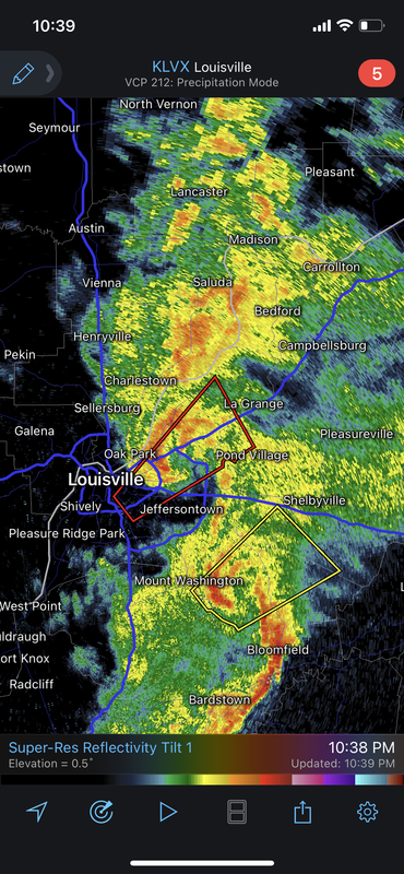
Kinda odd setup to trail a line of storms like this
This post was edited on 3/18/22 at 10:41 pm
Posted on 3/18/22 at 10:43 pm to deltaland
I was just about to post that. Couple of gnarly looking bowing segments. Wouldn't be a bit surprised to see the other one get warned.
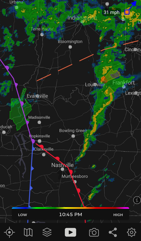
Posted on 3/18/22 at 10:46 pm to LegendInMyMind
Yep....that'll do it. Those fronts are a little farther East now and what is firing that line of storms.
This post was edited on 3/18/22 at 10:55 pm

Posted on 3/19/22 at 8:47 am to LegendInMyMind
(no message)
This post was edited on 3/20/22 at 6:51 am
Posted on 3/19/22 at 9:02 am to Roll Tide Ravens
Might bode well for timing across Alabama.
Mississippi on Tuesday looks scary. It has everything. Jet stream splits (big divergence) which presents a ton of forcing. Ripping low level jet. Good instability. Hodos are troubling from the models.
Storm mode being messy is my remaining hope. Tons of forcing, a mostly moist column, and no cap could lead to clusters competing and no storms really able to fully realize the danger of these parameters.

Posted on 3/19/22 at 9:41 am to Duke
quote:
a mostly moist column
Isn't that a good thing?
Posted on 3/19/22 at 9:52 am to udtiger
Its a question of too much of a good thing for storms.
they all go up at once and interfere with each other vs getting some semi alone.
they all go up at once and interfere with each other vs getting some semi alone.
This post was edited on 3/19/22 at 9:53 am
Posted on 3/20/22 at 6:52 am to Duke
New SPC outlook for Monday and Tuesday. We now have a moderate risk already included for Tuesday.
Monday:

Tuesday:

Monday:
Tuesday:
Posted on 3/20/22 at 7:21 am to Roll Tide Ravens
Well...shite

 Page 13 of 94

Popular
Back to top