- My Forums
- Tiger Rant
- LSU Recruiting
- SEC Rant
- Saints Talk
- Pelicans Talk
- More Sports Board
- Fantasy Sports
- Golf Board
- Soccer Board
- O-T Lounge
- Tech Board
- Home/Garden Board
- Outdoor Board
- Health/Fitness Board
- Movie/TV Board
- Book Board
- Music Board
- Political Talk
- Money Talk
- Fark Board
- Gaming Board
- Travel Board
- Food/Drink Board
- Ticket Exchange
- TD Help Board
Customize My Forums- View All Forums
- Show Left Links
- Topic Sort Options
- Trending Topics
- Recent Topics
- Active Topics
Started By
Message


 0
0

Posted on 3/20/22 at 1:24 pm to TDsngumbo
Kinda odd the enhanced area is so small around the moderate.
My phone says high of 66 Tuesday and just rain no storms. I’m on the enhanced/slight line but 30 min south you’d be in moderate area.
Must be a tight window of an area with the right ingredients
My phone says high of 66 Tuesday and just rain no storms. I’m on the enhanced/slight line but 30 min south you’d be in moderate area.
Must be a tight window of an area with the right ingredients
Posted on 3/20/22 at 1:58 pm to LegendInMyMind
Praying for you and yours
Posted on 3/20/22 at 2:11 pm to deltaland
Potent Early Week Severe Weather Threat
quote:
There will be more than enough instability, abundant shear to organize and rotate updrafts, and upper level forcing to provide additional vertical motion. This is the recipe for a severe weather outbreak. That does not mean it is a certainty, as storms could end up being in a line vs having individual cells running alone. A more linear storm mode keeps the high wind and hail risk very elevated, but takes the high end tornadoes off the table. I will be watching the convective allowing models over the next day to see how they evolve the storms. Do we get the more dangerous discrete cells or more of a linear structure?
At this point, it’s good to be aware of the risk of a significant severe weather outbreak along and south of I20. With that, you should have a plan for what to do if a tornado is threatening. Those in mobile homes should also have a plan for non-tornadic severe storms as straight line winds can still do substantial damage to mobile homes. Have a way to receive warnings all day, and take those warnings seriously.
This post was edited on 3/20/22 at 2:37 pm
Posted on 3/20/22 at 2:36 pm to Duke
you got an extra https// in that link btw
Posted on 3/20/22 at 2:37 pm to jigem
quote:
you got an extra https// in that link btw
Good looking out.
Fixed it
Posted on 3/20/22 at 4:26 pm to rt3
well i have to head up to jackson on tuesday, is it a higher chance that i get hit by a tornado or get shot?

Posted on 3/20/22 at 4:29 pm to Duke
quote:
quote:
It was an innuendo. Duke took me seriously
It hurts to miss a sex joke
Posted on 3/20/22 at 4:30 pm to DVinBR
quote:
well i have to head up to jackson on tuesday, is it a higher chance that i get hit by a tornado or get shot?
just playing russian roulette before you leave. Same chances.

Posted on 3/20/22 at 4:35 pm to DVinBR
You’ll be fine. Just take normal precautions when driving in heavy rain
Posted on 3/20/22 at 5:35 pm to trussthetruzz
im going to be driving back south straight through the heart of the moderate risk area after 2pm, going to be very interesting
Posted on 3/20/22 at 5:46 pm to DVinBR
The brush fires are on the outskirts of Wichita Falls....just West and this one is consuming homes, wildlife and cattle...no loss of life that I have heard of. We are not in harm's way - though it is rather near. Anxious for tomorrow's rainfall to knock down this fire danger
Posted on 3/20/22 at 6:41 pm to DVinBR
quote:
im going to be driving back south straight through the heart of the moderate risk area after 2pm, going to be very interesting
Dont be afraid to stop if it looks really sketchy in front of you. Not sure how far south the really bad stuff will be, but that stretch in Mississippi south of Jackson is a good bet to get some nastiness.
Posted on 3/20/22 at 6:47 pm to wfallstiger
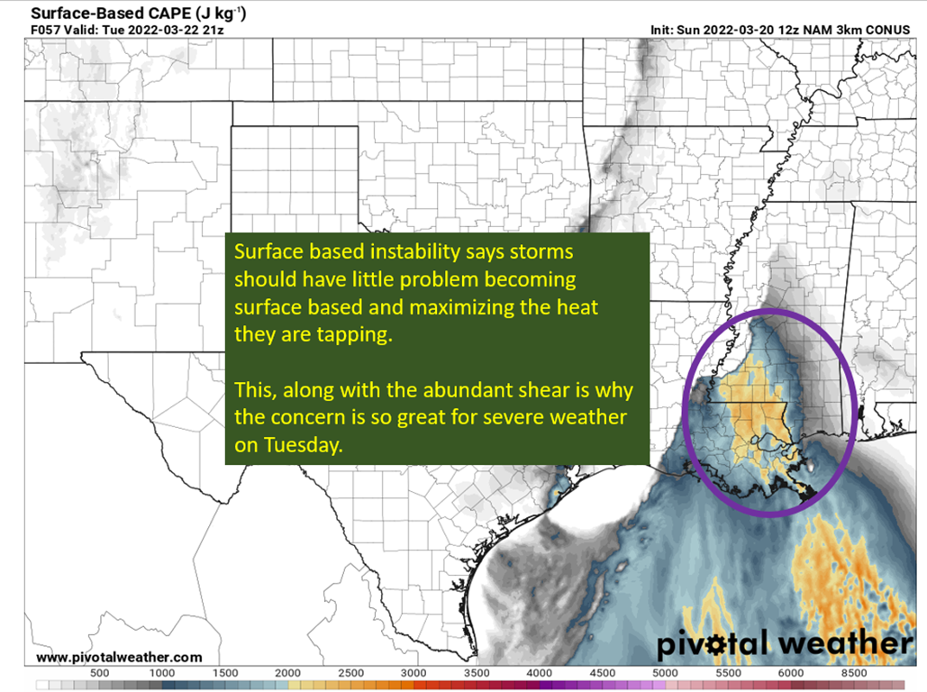
Alright. I've sat down again.
Some of the soundings out ahead of the main line are concerning. Pulling a PDS sounding for this area shouldn't be easy, and I've pulled three on the 18z NAM, two in LA and one in MS.
Right now, it is showing storms firing ahead of the line in SE LA into extreme Southern MS. We will need to see if that trend continues, and if it does....look out. The parameters out front of the line will be more than enough to sustain any storm that can start wrapping up, and there will be no lack of shear and enough energy to get the job done.
This post was edited on 3/20/22 at 6:49 pm

Posted on 3/20/22 at 7:03 pm to wfallstiger
quote:
wfallstiger
I noticed the wind has been blowing today for your area, with gusts approaching 40 mph and temps near 80 degrees. Hopefully the rain and cooler weather will be a blessing tomorrow, but unfortunately conditions are brutal right now.
I guess a steady rain for a day or so is too much to ask for. Instead, you get a big system that cranks up the dangerous conditions before you get any relief.
Posted on 3/20/22 at 7:04 pm to LegendInMyMind

fricking tits this is useful.

Posted on 3/20/22 at 7:05 pm to rt3
quote:
SPC issues MODERATE (level 4 of 5) threat for severe weather Tuesday in MS & LA
I live just north of the highest risk activity for Monday. Mississippi and Louisiana, prepare for long track tornadoes. And pull the cars in if you can because there will be hail.
Posted on 3/20/22 at 7:08 pm to Duke
So will I be in clear Tuesday or is there a chance the severe stuff trends north of Jackson
Posted on 3/20/22 at 7:12 pm to deltaland
You know I aint going to give you an all clear at this point.
But I expect the worst to be to your south.
But I expect the worst to be to your south.
Posted on 3/20/22 at 7:26 pm to Duke
quote:
fricking tits this is useful.
That looks a whole lot like Cameron Nixon's work. I know he first started fooling around with it. I like it!
ETA: Is it on the free Pivotal?
This post was edited on 3/20/22 at 7:27 pm

 Page 16 of 94

Popular
Back to top