- My Forums
- Tiger Rant
- LSU Recruiting
- SEC Rant
- Saints Talk
- Pelicans Talk
- More Sports Board
- Fantasy Sports
- Golf Board
- Soccer Board
- O-T Lounge
- Tech Board
- Home/Garden Board
- Outdoor Board
- Health/Fitness Board
- Movie/TV Board
- Book Board
- Music Board
- Political Talk
- Money Talk
- Fark Board
- Gaming Board
- Travel Board
- Food/Drink Board
- Ticket Exchange
- TD Help Board
Customize My Forums- View All Forums
- Show Left Links
- Topic Sort Options
- Trending Topics
- Recent Topics
- Active Topics
Started By
Message
re: Preliminary Ratings: Lacombe Tornado - EF1; NOLA/Arabi Tornado - EF3
Posted on 3/20/22 at 7:27 pm to Duke
Posted on 3/20/22 at 7:27 pm to Duke
If the dust up is this strong already I have concerns for those of you further to the East and South....stay aware and safe. Should not be severe of significance where we are but not too far East and South
 0
0

Posted on 3/20/22 at 7:28 pm to LegendInMyMind
Yeah its free on pivotal for some models.
I only use the free stuff.
I only use the free stuff.
Posted on 3/20/22 at 7:37 pm to Duke
do we have a timing yet?
Posted on 3/20/22 at 7:38 pm to DVinBR
Afternoon, like around or after 3 for I55 zone. At least thats what it looksnlike currently.
Posted on 3/20/22 at 7:39 pm to DVinBR
quote:
do we have a timing yet?
The optimal time.
Posted on 3/20/22 at 7:47 pm to Duke
welp, i might be storm chasing without actually storm chasing, i do have radarscope, i should be good as long as i stay away from the hook echoes, but that doesn't guarantee me getting hit by downdraft winds and hail
Posted on 3/20/22 at 7:52 pm to DVinBR
You always have the option not to drive during severe weather.
Posted on 3/20/22 at 8:04 pm to LegendInMyMind
well that doesn't guarantee me, everywhere im at on tuesday is in the current moderate risk area

Posted on 3/20/22 at 8:13 pm to DVinBR
quote:
well that doesn't guarantee me, everywhere im at on tuesday is in the current moderate risk area
If you’re going to be driving all day Tuesday within the moderate risk area, have a good way to get warnings on your phone and seek shelter in a sturdy building if you are in a warning. That’s your best bet if you have to be out and about once the severe weather starts on Tuesday.
Posted on 3/20/22 at 8:15 pm to DVinBR
By that I just meant if you're driving in an imminent severe weather threat......stop and find a place to take shelter. Just get out of the car. Wherever it is you're trying to get can wait, I assure you.
ETA: A vehicle is literally the deadliest place you can be in a tornado or high wind event, particularly if you don't know what you are doing in regards to reading a radar and judging storm motion.
ETA: A vehicle is literally the deadliest place you can be in a tornado or high wind event, particularly if you don't know what you are doing in regards to reading a radar and judging storm motion.
This post was edited on 3/20/22 at 8:17 pm
Posted on 3/20/22 at 9:12 pm to Duke
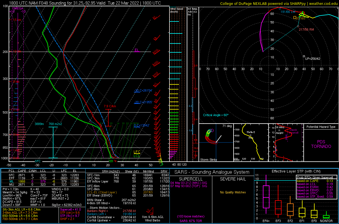
SW Louisiana looks ripe, too. I just took a look at the 3kEHI. It tops out around 10 in that area. This sounding is near Alexandria, which is outside of the MOD risk area:
Waiting on the 00z NAM now.
Waiting on the 00z NAM now.
Posted on 3/20/22 at 9:16 pm to LegendInMyMind
Front might be a little slower than has been expected and shift the risk a little farther west.
Posted on 3/20/22 at 9:18 pm to Duke
00z pulls a similar sounding. Those hodors (hat tip to tBoat) looking ominous.
Posted on 3/20/22 at 9:22 pm to Duke
You can follow that swath of high EHI all the way across and pull PDS soundings. I don't know that I've seen anything quite like that.
Posted on 3/20/22 at 9:27 pm to Duke
seems like the HRRR likes to keep things more linear in nature, subject to change though as usual


Posted on 3/20/22 at 9:35 pm to LegendInMyMind
quote:
You always have the option not to drive during severe weather.
But, Momma, it's where the fun is.
Posted on 3/20/22 at 9:39 pm to DVinBR
quote:
seems like the HRRR likes to keep things more linear in nature, subject to change though as usual
Yeah, but those discrete cells well in front of the line are no bueno. You don't see them on your frame, but they fire heading into Southern MS.
This post was edited on 3/20/22 at 9:41 pm
Posted on 3/20/22 at 9:49 pm to DVinBR
It has some individual cells fire.
In typical fashion, fire around I12 and mature as they go north. If tradition is any indicator, they'll go tornadic when they move into the Jackson forecast office zone of control.
But linear is certainly better for most.
In typical fashion, fire around I12 and mature as they go north. If tradition is any indicator, they'll go tornadic when they move into the Jackson forecast office zone of control.
But linear is certainly better for most.
Posted on 3/20/22 at 9:55 pm to LegendInMyMind
quote:
ay be out of commission on this one, baws. We just had a death in the family and have all that goes with it going. Just send some "thoughts and prayers" my way and buckle down the hatches. It could be a rough ride.
Sorry legend
Posted on 3/20/22 at 10:13 pm to Wishnitwas1998
quote:
Sorry legend
Thanks, bud.

 Page 17 of 94

Popular
Back to top