- My Forums
- Tiger Rant
- LSU Recruiting
- SEC Rant
- Saints Talk
- Pelicans Talk
- More Sports Board
- Coaching Changes
- Fantasy Sports
- Golf Board
- Soccer Board
- O-T Lounge
- Tech Board
- Home/Garden Board
- Outdoor Board
- Health/Fitness Board
- Movie/TV Board
- Book Board
- Music Board
- Political Talk
- Money Talk
- Fark Board
- Gaming Board
- Travel Board
- Food/Drink Board
- Ticket Exchange
- TD Help Board
Customize My Forums- View All Forums
- Show Left Links
- Topic Sort Options
- Trending Topics
- Recent Topics
- Active Topics
Started By
Message
re: Official Harvey Observation Thread
Posted on 8/26/17 at 7:54 am to slackster

Posted on 8/26/17 at 7:54 am to slackster
I can deal with rain. Doesn't flood where I am but my sister and brother it can be a concern for.
Not sure if I still need to worry about generator gas today or not. Will probably grab like 20 gallons just in case I guess but doubt we get too much wind to take out power polls at this point.
Not sure if I still need to worry about generator gas today or not. Will probably grab like 20 gallons just in case I guess but doubt we get too much wind to take out power polls at this point.
 0
0

Posted on 8/26/17 at 7:55 am to slackster
slackster any guesses on when I could get in to port O'Connor or palacios this week?
I've got some clean up and hopefully boat retrieval to do
I've got some clean up and hopefully boat retrieval to do
Posted on 8/26/17 at 7:55 am to slackster
For the Houston folks, the HRRR is showing nearly 13" of rainfall expected in the Houston area over the next 18 hours.


Posted on 8/26/17 at 7:57 am to stout
quote:
What if I told you that the rain this far has practically been non existent and the sun is shining this morning?
Where are you located exactly in TX
Posted on 8/26/17 at 8:00 am to Mulat
quote:
Where are you located exactly in TX
I'm not. I am 30 minutes directly North of Lake Charles
Posted on 8/26/17 at 8:01 am to cgrand
quote:
slackster any guesses on when I could get in to port O'Connor or palacios this week?
I've got some clean up and hopefully boat retrieval to do
Tough call. In 96 hours, every major model has the storm basically in the exact area it is right now. The Euro actually has it over water due south of Port O'Conner in 96 hours.
Probably won't be dealing with major wind keeping you out, but flooding in that area may be a concern, and utility crews may be quite a while before they get things right.
Posted on 8/26/17 at 8:09 am to slackster
ok thanks I'll keep watching
if anyone's interested we will be hauling supplies, chain saws, gas etc from BR down to there as soon as it's safe. there will be plenty to do and plenty of people that need help
if anyone's interested we will be hauling supplies, chain saws, gas etc from BR down to there as soon as it's safe. there will be plenty to do and plenty of people that need help

Posted on 8/26/17 at 8:18 am to cgrand
Official report from College Station:
As of 8:14 am I have received 1.4 inches of rain....squalls are off and on with gust up to 25 knots.
I have to do trauma anesthesia this evening @ St. Joes in Bryan. I will follow up with rain totals throughout the day.
Praying for all and hoping for a evening in which people stay off the roads.
As of 8:14 am I have received 1.4 inches of rain....squalls are off and on with gust up to 25 knots.
I have to do trauma anesthesia this evening @ St. Joes in Bryan. I will follow up with rain totals throughout the day.
Praying for all and hoping for a evening in which people stay off the roads.

Posted on 8/26/17 at 8:18 am to cgrand
Our are of Cypress got 5 inches last night. No flooding of any sort, but that was only the pregame.
Posted on 8/26/17 at 8:21 am to Mr Sausage
quote:
Feeder band just dumped 5-6 inches across swath of Fort Bend in the last hour or two
My jobsite in sienna plantation was getting hammered throughout the night. It's right down the street from where a tornado bulldozed through.
7.5 inches yesterday, 5 inches since midnight thru this am. 12.5 total in about 18 hours according to our rain gauge.
Nuts that this isn't supposed to be the worst of the rain.
Posted on 8/26/17 at 8:39 am to rds dc
quote:
Trouble already for Houston? Watch the evolution of that convection in the black circle this evening. The HRRR is spitting out 12-16" over the eastern half of Houston tonight.

The big totals are a bit farther SW on the other side of 45 but the setup favoured training cells near the Houston area and the HRRR highlighted that.
Over 8 million people in those flood warnings. With Harvey moving little, this could get bad.


quote:
MESOSCALE PRECIPITATION DISCUSSION 0736...CORRECTED NWS WEATHER PREDICTION CENTER COLLEGE PARK MD 843 AM EDT SAT AUG 26 2017 CORRECTED FOR TYPO IN FIRST DISCUSSION PARAGRAPH AREAS AFFECTED...SOUTHEAST TX & SOUTHWEST LA CONCERNING...HEAVY RAINFALL...FLASH FLOODING LIKELY VALID 261240Z - 261840Z SUMMARY...HURRICANE HARVEY CONTINUES TO MOVING NORTHWARD THROUGH SOUTHEAST TX. HOURLY RAIN TOTALS UP TO 3" WITH LOCAL AMOUNTS TO 7" ARE EXPECTED. SIGNIFICANT FLASH FLOODING IS ANTICIPATED. DISCUSSION...THE EYE OF HURRICANE HARVEY CONTINUES TO FILL IN ON RADAR AND SATELLITE IMAGERY THIS MORNING WHILE MOVING FARTHER INTO SOUTHEAST TX. PRECIPITABLE WATER VALUES ARE UP TO ~2.75" PER GPS DATA. INFLOW AT 850 HPA IS 25-50 KTS PER VAD WIND PROFILES, BUT ARE LIKELY AS HIGH AS 80 KTS GIVEN HARVEY'S INTENSITY. THE INFLOW IS NEARLY DOUBLE THE 850 HPA WIND, WHICH IS LEADING TO PRECIPITATION EFFICIENCY. UNIDIRECTIONAL FLOW WITHIN THE LOW- TO MID-LEVELS COMBINED WITH BULK SHEAR OF AT LEAST 30 KTS IS LEADING TO ORGANIZED CYCLONIC BANDING. ON WATER VAPOR IMAGERY, SHORTWAVES ALOFT ARE EVIDENT ACROSS OK/THE TX PANHANDLE AND CENTRAL MEXICO TO THE SYSTEM'S WEST, WHICH COMBINED WITH STABLE CONDITIONS INLAND ARE LEADING TO ITS LOPSIDED CONVECTIVE APPEARANCE FAVORING THE EASTERN SIDE OF ITS CIRCULATION. THERE IS A STRONG SIGNAL IN THE MESOSCALE GUIDANCE FOR 7" OF RAINFALL WITHIN THE NEXT SIX HOURS. COMBINED WITH THE 3-12" OF RAINFALL THIS REGION HAS ALREADY RECEIVED, SENSITIVE URBAN AREAS IN THE HOUSTON METROPOLITAN AREA, DAM ISSUES IN PORT ARTHUR TX, AND ABOVE AVERAGE RAINFALL IN SOUTHWEST LA IN 2017, SIGNIFICANT FLASH FLOODING IS EXPECTED ACROSS SOUTHWEST TX, WITH FLASH FLOOD RISK IN SOUTHWEST LA INCREASING WITH TIME AS A INFLOW BAND MOVING IN FROM THE SOUTHWEST INTERSECTS OR MERGES WITH EXISTING ACTIVITY NEAR THE EFFECTIVE STATIONARY FRONT.

Posted on 8/26/17 at 8:40 am to baseballmind1212
Early morning visible imagery showing most active tops in the feeder bands over Houston and offshore...
nothing we couldn't tell from surface obs but it looks really pretty

nothing we couldn't tell from surface obs but it looks really pretty

Posted on 8/26/17 at 8:43 am to baytiger
How much rain could SE Louisiana get over the next few days? Looks like the amount is getting lower and lower from the way the storm is moving. I am around Thibodaux.
Posted on 8/26/17 at 8:49 am to shoelessjoe
Back Vacherie and Kramer gone be fine brah
Posted on 8/26/17 at 8:52 am to baseballmind1212
quote:
My jobsite in sienna plantation was getting hammered throughout the night. It's right down the street from where a tornado bulldozed through.
I lived through it last night. We got very lucky. Others very close to us were damaged. Insane tornado

Posted on 8/26/17 at 8:53 am to Tiger Ryno
I ya holding up Ryno?
Posted on 8/26/17 at 8:55 am to Tiger Ryno
I hope this isn't right, but if it is it's already ahead of the predicted rise to within 0.6 feet of the record
ETA - the forecast was just updated right after my OP to a record.
LINK

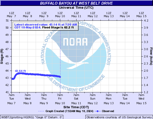
ETA - the forecast was just updated right after my OP to a record.
LINK
This post was edited on 8/26/17 at 9:04 am
Posted on 8/26/17 at 8:57 am to rds dc

I buy some huge rain totals for Houston today the way this is set up. The feeder train looks like it's going to roll over Houston. WV image has the tap wide open.
Posted on 8/26/17 at 8:58 am to NorthEndZone
From the other Harvey thread:
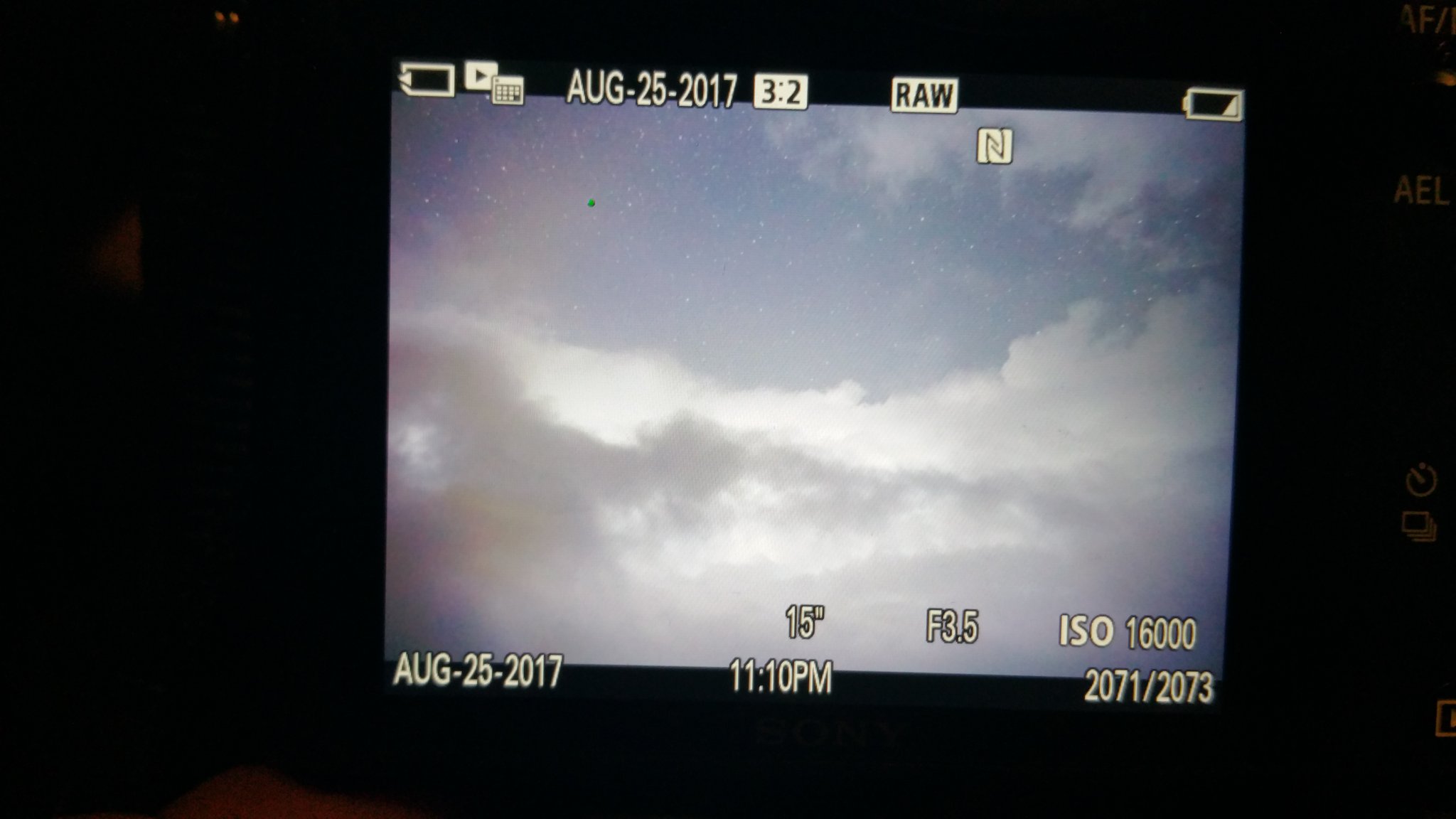
Lightning illuminating the stadium features of the eye. You can see the stars through the eye. That is going to be one helluva shot.
Lightning illuminating the stadium features of the eye. You can see the stars through the eye. That is going to be one helluva shot.

Posted on 8/26/17 at 8:58 am to NorthEndZone
What yall post the river gauge readings, can you link them? I'd like to read the info below the chart giving the various level data points and what will be affected

 Page 13 of 38

Popular
Back to top