- My Forums
- Tiger Rant
- LSU Recruiting
- SEC Rant
- Saints Talk
- Pelicans Talk
- More Sports Board
- Fantasy Sports
- Golf Board
- Soccer Board
- O-T Lounge
- Tech Board
- Home/Garden Board
- Outdoor Board
- Health/Fitness Board
- Movie/TV Board
- Book Board
- Music Board
- Political Talk
- Money Talk
- Fark Board
- Gaming Board
- Travel Board
- Food/Drink Board
- Ticket Exchange
- TD Help Board
Customize My Forums- View All Forums
- Show Left Links
- Topic Sort Options
- Trending Topics
- Recent Topics
- Active Topics
Started By
Message
re: Official Arctic Air Blast/Winter Weather Thread
Posted on 1/15/24 at 7:36 pm to HoboDickCheese
Posted on 1/15/24 at 7:36 pm to HoboDickCheese
What are the odds the Atchafalaya Basin is shut down in the next 2 hours?
 2
2

Posted on 1/15/24 at 7:36 pm to HoboDickCheese
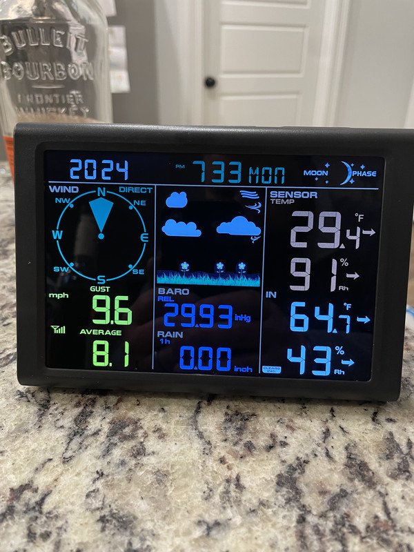
Wife got me a weather station for my birthday today. I love it. Updates every 16 seconds. This is in Youngsville, LA.
Posted on 1/15/24 at 7:37 pm to omarlittle
Next 2 hrs? Close to zero

Posted on 1/15/24 at 7:37 pm to TDsngumbo
Downtown St. Amant????
Posted on 1/15/24 at 7:38 pm to omarlittle
Very possible. Even if it’s not I would not be on it.

Posted on 1/15/24 at 7:40 pm to dukke v
Just raining by LSU

Posted on 1/15/24 at 7:40 pm to LPLGTiger
Got a link for that weather station? My dad would love that shite


Posted on 1/15/24 at 7:44 pm to Roll Tide Ravens

Mesoscale Discussion 0071
NWS Storm Prediction Center Norman OK
0732 PM CST Mon Jan 15 2024
Areas affected...Southern LA...south-central MS...northern
AL...northwest GA...and southeast TN
Concerning...Winter mixed precipitation
Valid 160132Z - 160600Z
SUMMARY...Winter mixed precipitation (primarily freezing rain and
sleet) will continue across portions of the Southeast into the
overnight hours.
DISCUSSION...Latest surface observations and web cams show a
continuation of light freezing rain extending from southern LA
northeastward into southeast TN this evening. This precipitation is
generally being aided by a persistent low-level frontogenetic
circulation and steady low-level warm advection across the region.
This forcing for ascent should remain fairly persistent and
quasi-stationary through about 06Z, with a slight southeastward
evolution of the frontogenetic band with time.
The 00Z observed JAN sounding depicts an 8 dec C warm nose atop a
substantial (albeit shallow) sub-freezing layer (minimum wet bulb
temperature of -8 deg C). Any descending ice should completely melt
before re-freezing at the surface, suggesting that freezing rain
will remain the predominant precipitation type. Farther north toward
northwest GA and southeast TN, a deeper sub-freezing layer and
minimal warm nose may favor a mix of sleet and freezing rain. While
dry air aloft overspreading the region (evident in water vapor
imagery and observed/forecast soundings) and modest forcing for
ascent may temper overall precipitation rates, the quasi-stationary
forcing will support a fairly prolonged period of light to moderate
freezing rain and sleet, with localized bursts of higher rates
possible in the more robust cores.
Colder surface temperatures will gradually spread southeastward and
support freezing rain in areas currently above freezing during the
next few hours (i.e., portions of southeast LA and east-central MS).
Posted on 1/15/24 at 7:45 pm to LPLGTiger
Oh what brand/model is that?? My husband might love that and our anniversary is coming up.
Posted on 1/15/24 at 7:45 pm to Roll Tide Ravens

Posted on 1/15/24 at 7:45 pm to LPLGTiger
And happy birthday!
Posted on 1/15/24 at 7:47 pm to tiger91
Precip finally looks to have cleared my area, now for the brutal cold. Let's see if we hit 5° tonight. Then, dread the 0° tomorrow night.
19° now.
19° now.
This post was edited on 1/15/24 at 7:48 pm

Posted on 1/15/24 at 7:52 pm to LegendInMyMind
light rain has started over by Jones Creek, brought the trash can in and felt some ice start to form on top of it

Posted on 1/15/24 at 7:53 pm to dukke v
Got a light dusting of sleet/snow at the camp on spring bayou
Posted on 1/15/24 at 7:53 pm to Bayou_Tiger_225
My golden keeps wanting to go outside to play in the rain

Posted on 1/15/24 at 7:54 pm to tiger91
For those asking about weather stations
This one is the best I have found for the price. Has every measurement and feature you could want in a personal weather station.
Ambient Weather Station
This one is the best I have found for the price. Has every measurement and feature you could want in a personal weather station.
Ambient Weather Station

Posted on 1/15/24 at 7:54 pm to Nitrogen
My phone says heavy snow for hundred oaks/garden district. I don’t see anything outside.

Posted on 1/15/24 at 7:55 pm to Nitrogen
Steady light rain in mid city.
Ice on top the car.
That didn’t take much nor did it take long.
Ice on top the car.
That didn’t take much nor did it take long.
Posted on 1/15/24 at 7:56 pm to bayoubengals88
The road is shiny under the street light. Meaning, not dry.
Matter of time before that freezes with minimal traffic.
Matter of time before that freezes with minimal traffic.

 Page 34 of 59

Popular
Back to top