- My Forums
- Tiger Rant
- LSU Recruiting
- SEC Rant
- Saints Talk
- Pelicans Talk
- More Sports Board
- Fantasy Sports
- Golf Board
- Soccer Board
- O-T Lounge
- Tech Board
- Home/Garden Board
- Outdoor Board
- Health/Fitness Board
- Movie/TV Board
- Book Board
- Music Board
- Political Talk
- Money Talk
- Fark Board
- Gaming Board
- Travel Board
- Food/Drink Board
- Ticket Exchange
- TD Help Board
Customize My Forums- View All Forums
- Show Left Links
- Topic Sort Options
- Trending Topics
- Recent Topics
- Active Topics
Started By
Message
 0
0

Posted on 3/24/23 at 7:10 am to Lsuhoohoo
Awfully red sky around here this morning. Little creepy
Posted on 3/24/23 at 7:34 am to Roll Tide Ravens
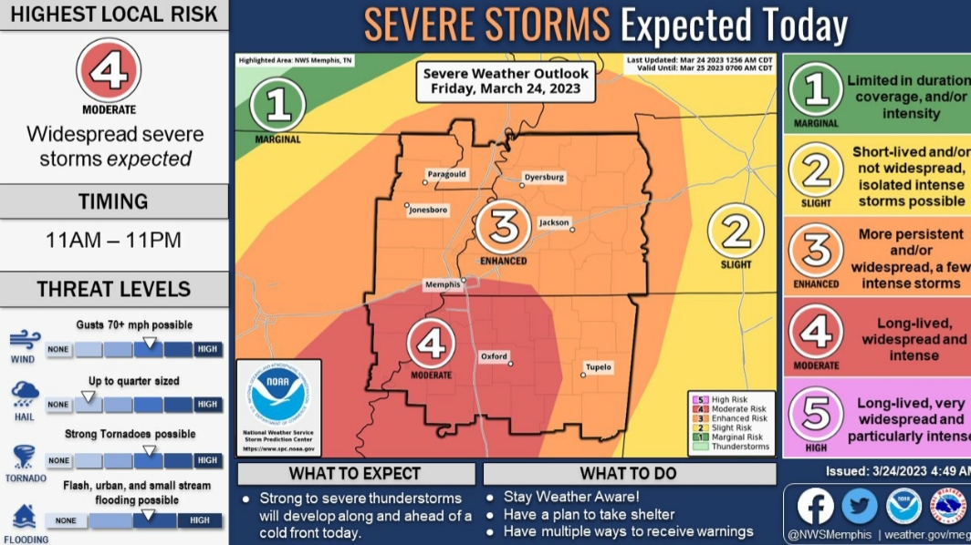
The HRRR is being most aggressive with the setup. It’s a solution we do not want to materialize
ETA from the latest SPC update
ETA from the latest SPC update
quote:
Across southeast Arkansas, northern Louisiana, and northwest Mississippi, a more volatile environment will develop Friday evening/early overnight. More discrete convection is anticipated on the southern periphery of the aforementioned QLCS. The more discrete mode, combined with greater instability and strong shear should allow for multiple supercells to develop across northern Louisiana and southern Arkansas and move northeastward. Low-level hodographs are very favorable in this region with 0-500m SRH around 200 m2/s2 and 0-1km SRH 300+ m2/s2. Therefore, any sustained supercells will be capable of producing strong to intense (EF3+) tornadoes, with long-track tornadoes possible with any longer-lived, undisturbed supercells. 00Z HREF members showed a variety of solutions which cast some uncertainty on the forecast. WRF members are notably less bullish with warm sector supercell development from northeast Louisiana into northern Mississippi while the HRRR was most aggressive with convective coverage and environment. After further investigation it appears the more aggressive HRRR solution can be attributed to a more robust mass response during the afternoon/early evening hours. This results in a pronounced shortwave trough which can be seen at 700 and 850mb and reflected as a significant confluence zone at the surface. Not only does this act as a forcing for storm development, but it also acts as moisture convergence with a more broad region of 70+F dewpoints. In this scenario, numerous strong tornadoes would be likely, with the potential for several intense tornadoes. Despite being the most aggressive, this solution does not seem unreasonable as similar low-level confluence features can been on both the 00Z GFS and the 18Z ECMWF. As is often the case, the severity of the tornado threat across the moderate risk will be modulated by mesoscale influences in the region. As the event approaches, these mesoscale effects may become more clear and allow the greatest risk corridor to become better defined. ..Bentley/Weinman.. 03/24/2023
This post was edited on 3/24/23 at 7:37 am
Posted on 3/24/23 at 8:30 am to deltaland
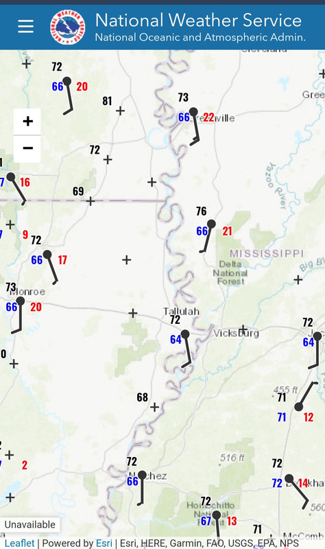
We are already at 70°/upper 60°s across the open warm sector. Satellite shows only thin cloud cover across the area of most concern. Overnight the hail probability was bumped up with a 15% hatched across the Arklamiss region. Very large hail possible, along with the tornado threat.
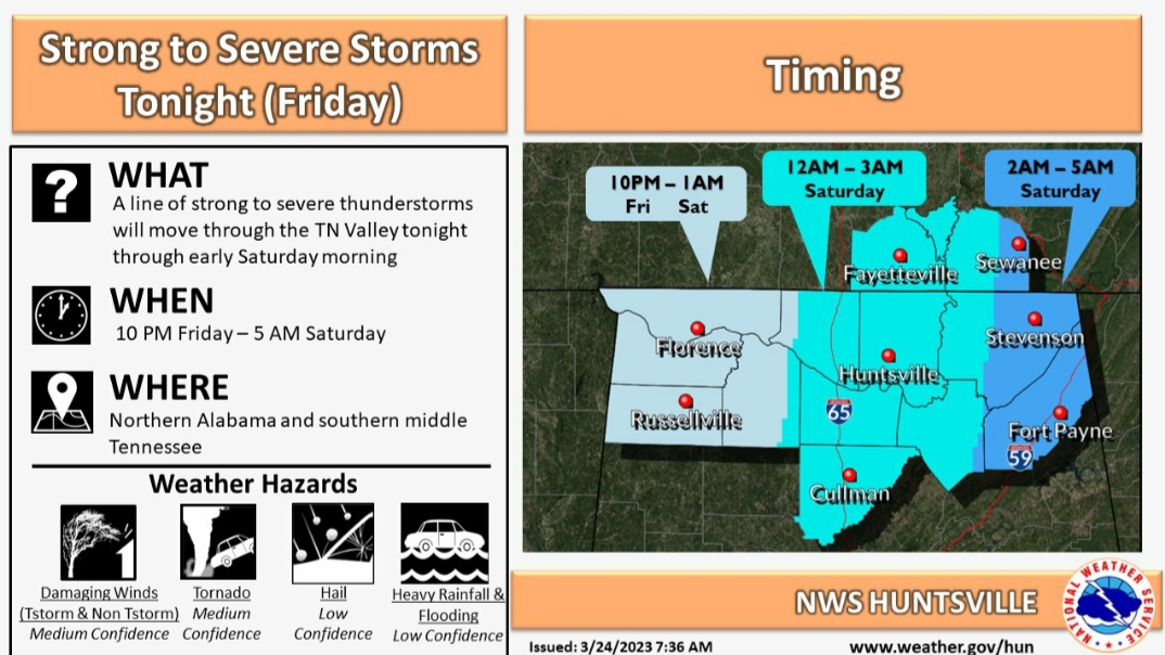
North AL folks, it still looks like we will have a stout line coming through late night/early morning. It will have enough to work with to possibly put down a few spin-up tors, but high winds will be our main concern.
Watch this one carefully, as this is our first true Spring setup of the year. Warm sector should have temps above 80° with dews in the mid 60s. The HRRR is pretty much dead on with current temps/dews.
Posted on 3/24/23 at 8:31 am to LegendInMyMind
Sun has been out here most of the morning very sparse cloud cover
Posted on 3/24/23 at 8:36 am to LegendInMyMind
I read dewpoints could reach low 70s in north La, central MS
Posted on 3/24/23 at 8:50 am to deltaland
They could, but right now both the HRRR and NAM have them struggling to reach 70°. NAM, like always, is still running cool with temperatures, though. It has low 70s for most of the area.
Posted on 3/24/23 at 8:53 am to LegendInMyMind
Discrete cells here last night. They were proud of themselves - noisy, Heavy rainfall
Posted on 3/24/23 at 8:54 am to LegendInMyMind
Timing for north AL:

Posted on 3/24/23 at 8:55 am to wfallstiger
Feels like Spring is deciding its time.
Seems like every Thursday the last 3 weeks we've had significant weather here in DFW
Seems like every Thursday the last 3 weeks we've had significant weather here in DFW

Posted on 3/24/23 at 8:57 am to 50_Tiger
quote:
Seems like every Thursday the last 3 weeks we've had significant weather here in DFW
Not “seems like it”. It has. Local Thursday league is so backed up with makeup matches that they are now scheduling 2-3/day starting at 7:00 am.
Posted on 3/24/23 at 8:57 am to LegendInMyMind
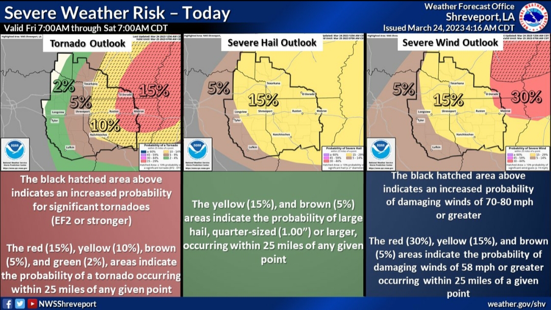
Good graphic from NWS Shreveport:
Posted on 3/24/23 at 9:00 am to LegendInMyMind
Posted on 3/24/23 at 9:03 am to 50_Tiger
Sure seems like we are on a seven day cycle...looks to be another in about a week
Posted on 3/24/23 at 9:25 am to LegendInMyMind
Hell it’s 71 here now with Dewpoint of 65 and sun is shining bright
High today is 83. If humidity holds around the current 79% that’s a mid 70s DP but perhaps humidity will fall as day goes on
High today is 83. If humidity holds around the current 79% that’s a mid 70s DP but perhaps humidity will fall as day goes on
Posted on 3/24/23 at 9:40 am to LegendInMyMind
Can you interpret that for us?

Posted on 3/24/23 at 9:42 am to LegendInMyMind
Literally just left Bossier City. Hoping to out run it.
Posted on 3/24/23 at 9:45 am to LegendInMyMind

 Page 4 of 32

Popular
Back to top