- My Forums
- Tiger Rant
- LSU Recruiting
- SEC Rant
- Saints Talk
- Pelicans Talk
- More Sports Board
- Coaching Changes
- Fantasy Sports
- Golf Board
- Soccer Board
- O-T Lounge
- Tech Board
- Home/Garden Board
- Outdoor Board
- Health/Fitness Board
- Movie/TV Board
- Book Board
- Music Board
- Political Talk
- Money Talk
- Fark Board
- Gaming Board
- Travel Board
- Food/Drink Board
- Ticket Exchange
- TD Help Board
Customize My Forums- View All Forums
- Show Left Links
- Topic Sort Options
- Trending Topics
- Recent Topics
- Active Topics
Started By
Message
re: Morganza Spillway may or may not open for a 3rd time -- lack of clear info from ACoE
Posted on 2/28/19 at 1:54 pm to lsuKountRy
Posted on 2/28/19 at 1:54 pm to lsuKountRy
quote:well yes, its not going to crest until mid march so it would do that.
Getting higher by the day
 0
0

Posted on 2/28/19 at 2:02 pm to TDsngumbo
Col. Clancy believes that Morganza will be opened. As of today, the projection shows it would not be opened but with more rain and snow melt coming down the projected 1.45 million CFPS is it highly likely that the 1.5 million CFPS threshold will force them to open it up. The Control structure total water flow is currently 50/50 right now between the Atchafalaya and Miss River and likely to increase to 60/40 in favor of the Atchafalaya.
Posted on 2/28/19 at 2:04 pm to lsuKountRy
quote:
our concerns are elevated this year due to the saturated ground
Yep in 2011 we were in big time drought when it got this high. This year not so much
Posted on 2/28/19 at 2:10 pm to MrLSU

Major flooding near Memphis.
Posted on 2/28/19 at 2:14 pm to Midtiger farm
quote:
2011 we were in big time drought
I remember a farmer who had crops on both sides of the levee saying "one the river side my crops are flooded and on the land side they are shriveling up".
It being so dry could be a difference from what happened in '11. Some towns along the river normally are able to let their rain runoff go into the river but at a certain height that isn't possible.
and fyi, the lifejacket steward says that new shipments should be arriving next tues at the latest. Which is good but due to tariffs with china it will be a limited amount and they will likely be rationed.

Posted on 2/28/19 at 2:18 pm to Chuker
Looking at Google images, I see on Profit Island (middle of the river just north of Baton Rouge) there are two structures there. Surely they're not homes but are they some sort of research facilities or are they camps?
Posted on 2/28/19 at 2:20 pm to jimbeam
quote:
I would assumed that is the unit price to pump. I would say that it is not feasible to pump sediment 200 Miles. That would require like 50-75 booster pumps along the way, or a ton of barging. Like I said previously, typically the USACE or even CPRA has not pumped further than 20 Miles or so MAX and even then it’s super expensive.
Right. Maybe this is the time for some engineers to make a patent for themselves. We have a problem, we have a potential solution but with current it's hella expensive and maybe even problematic.
But we can put oil and other chemicals in 48 in pipes and send it hundreds of miles. Yes, sediment isn't liquid, but maybe they can send the liquid with the sediment suspended in it... I don't know. It just seems like it's a huge opportunity to solve two problems at once.
Posted on 2/28/19 at 2:27 pm to Chuker
quote:
and fyi, the lifejacket steward says that new shipments should be arriving next tues at the latest. Which is good but due to tariffs with china it will be a limited amount and they will likely be rationed.

Save your Sprite bottles.

Posted on 2/28/19 at 2:28 pm to MrLSU
What's the downside to opening the spillway?

Posted on 2/28/19 at 2:31 pm to TDsngumbo
quote:
Looking at Google images, I see on Profit Island (middle of the river just north of Baton Rouge) there are two structures there. Surely they're not homes but are they some sort of research facilities or are they camps?
I'm going with one research facility and one camp.
Look across the river to the East. How do you get into that racetrack? I think that's where cops, ambulance drivers, etc. train, but I want to take my car for an afternoon out there. I could have some fun.
Posted on 2/28/19 at 2:35 pm to TigerstuckinMS
quote:
Look across the river to the East. How do you get into that racetrack? I think that's where cops, ambulance drivers, etc. train, but I want to take my car for an afternoon out there. I could have some fun.
JESTC site run by LSP
Posted on 2/28/19 at 2:36 pm to Midtiger farm
quote:
2011
I saw a priest sprinkling holy water on the levees that year.
Posted on 2/28/19 at 2:38 pm to TigerstuckinMS
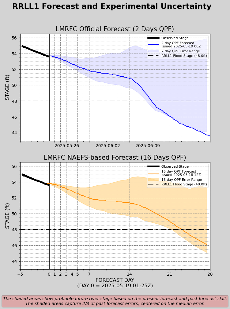
Red River Landing Forecast & Experimental Uncertainty Graph
Baton Rouge Forecast & Experimental Uncertainty Graph
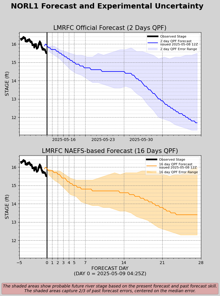
New Orleans Forecast & Experimental Uncertainty Graph
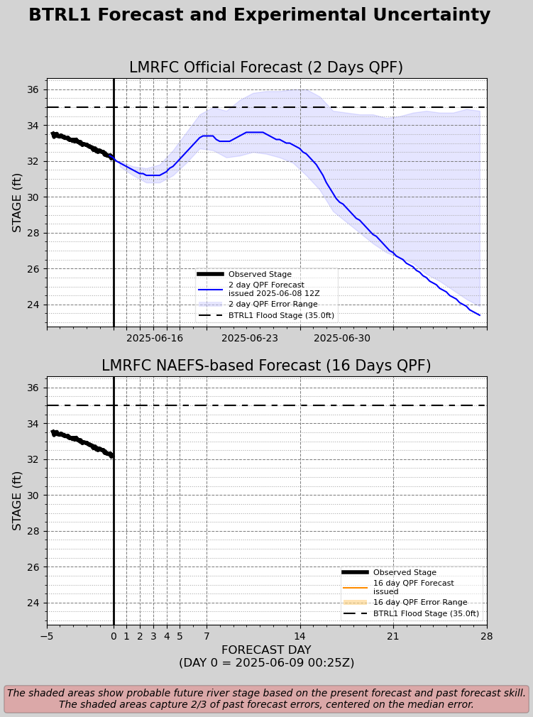
Baton Rouge Forecast & Experimental Uncertainty Graph
New Orleans Forecast & Experimental Uncertainty Graph
Posted on 2/28/19 at 2:44 pm to TigerstuckinMS
That is the Joint Emergency Services Training Center. It is not open to the public however normally just before Hunting season in the fall it is open for people to bring weapons to sight in. They shoot them and sight them for you. You are not allowed to shoot. Run by La. State Police.
Also Profit Island is mostly a private hunting club. Those are camps and they kill some big deer. It’s over 2000 acres.
Also Profit Island is mostly a private hunting club. Those are camps and they kill some big deer. It’s over 2000 acres.
This post was edited on 2/28/19 at 2:49 pm
Posted on 2/28/19 at 3:09 pm to MrLSU
Maybe I missed something, but why is the forecast outside of the margin of error?
Posted on 2/28/19 at 3:12 pm to MrLSU
quote:
The Control structure total water flow is currently 50/50 right now between the Atchafalaya and Miss River and likely to increase to 60/40 in favor of the Atchafalaya.
Isn't that pushing what ORCS was designed to do?
Posted on 2/28/19 at 3:31 pm to NYNolaguy1
Looking briefly at the wiki page, the ORCS was designed to take like 600,000 CFS with morganza floodway also taking 600,000 CFS, which would be roughly 50/50 with a MS River flowing around 1.2 or 1.3 Million CFS. I think that the ORCS is probably fine depending on how much flow morganza can take over 600k. You can look up the design flow parameters when they designed the whole system from the 50s until the 70s and it all presumes that the Mississippi still takes the bulk of the flow. The design assumes the total flow going up to 3 million CFS with the ORCS not going over 600k. Going 60/40 in favor of the Atchafalaya was not in the design. I think sedimentation of the MS river has caused this unexpected outcome. They just can't flow the design flow down the MS river because the bed is too high and it will overtop levees downstream of the ORCS and Morganza. This is def starting to get into danger territory for the system.
I recall some parish official from some prior year saying the levees were so saturated, leaking, and fragile "like a bowl of jello". YIKES
https://en.wikipedia.org/wiki/Project_design_flood
I recall some parish official from some prior year saying the levees were so saturated, leaking, and fragile "like a bowl of jello". YIKES
https://en.wikipedia.org/wiki/Project_design_flood
This post was edited on 2/28/19 at 3:34 pm
Posted on 2/28/19 at 3:35 pm to TDsngumbo
quote:
Looking at Google images, I see on Profit Island (middle of the river just north of Baton Rouge) there are two structures there. Surely they're not homes but are they some sort of research facilities or are they camps?
The one in SE of the island is an old dock.

Not sure what the other thing is but it looks like a metal building.
This post was edited on 2/28/19 at 3:38 pm
Posted on 2/28/19 at 3:37 pm to Supermoto Tiger
quote:
What's the downside to opening the spillway?
Baws won’t be able to get to their camps.
But for real, a lot of people have property (including livestock) in that area.
Posted on 2/28/19 at 4:09 pm to NYNolaguy1
quote:
Maybe I missed something, but why is the forecast outside of the margin of error?
The error range captures 2/3 of the past forecast centered on the median error, doesnt say anything specific about the uncertainties around the current forecast.
So for the 2 day QPF forecast at day 21 the median error is ~5 ft over the forecast w/ the upper third being about 9 ft above the forecast and the lower third of the errors about 1 ft above the forecast.
Basically, when you take into account only 2 days of forecast rain (assumes zero rain after that) the projected river stage 3 weeks out is going to be below the actual river stage an overwhelming majority of the time. Which is intuitive since rain after day 2 will still contribute flow and therefore raise the river stage. For the same reasons, the 16 day QPF tracks much closer to the center of the error range.
That's how I understand it, at least.
This post was edited on 2/28/19 at 4:12 pm

 Page 21 of 107

Popular
Back to top