- My Forums
- Tiger Rant
- LSU Recruiting
- SEC Rant
- Saints Talk
- Pelicans Talk
- More Sports Board
- Coaching Changes
- Fantasy Sports
- Golf Board
- Soccer Board
- O-T Lounge
- Tech Board
- Home/Garden Board
- Outdoor Board
- Health/Fitness Board
- Movie/TV Board
- Book Board
- Music Board
- Political Talk
- Money Talk
- Fark Board
- Gaming Board
- Travel Board
- Food/Drink Board
- Ticket Exchange
- TD Help Board
Customize My Forums- View All Forums
- Show Left Links
- Topic Sort Options
- Trending Topics
- Recent Topics
- Active Topics
Started By
Message
re: Morganza Spillway may or may not open for a 3rd time -- lack of clear info from ACoE
Posted on 2/25/19 at 7:51 am to TheChosenOne

Posted on 2/25/19 at 7:51 am to TheChosenOne
Hear hear
 0
0

Posted on 2/25/19 at 8:12 am to Picayuner
Wrong Baton Rouge is on Wells. Not sure about NOLA

Posted on 2/25/19 at 8:24 am to Mr. Misanthrope
quote:
boils and to see if they are percolating clean water or dirty?
Sand boils when the river gets historically high make me nervous as shite. It's difficult to figure out what's going on under ground near the levees and in more cases than the officials will want you to know about, sand boils are evidence of an underground slurry. This is when the ground beneath the surface basically becomes a mixture of sand, soil, and water and creates almost a quick sand type of situation. It happens when the weight and pressure of the high water pushes through weak spots under the levee and further weakens the weak spot by filling it with water.
What worries me is the sudden and unpredictable pushing through of the river water through one of these spots, eroding an enormous "under levee" break which then destroys a section of the levee. I know for a fact that there are at least two of these that are known to exist in the Baton Rouge metro area and southward. One in Iberville Parish and one in Ascension Parish, both on the western side of the levees. The scary thing is that each year the river gets high, these slurries get worse and the private fear among state and federal officials is that eventually they could give way if the pressure from high river levels gets high enough.
Posted on 2/25/19 at 9:18 am to White Roach
quote:
This will be the 13th time it's been opened since it was completed in 1931. Six of those openings are in the past 12 years, and this will be the third opening in four years.
Wow. That’s alarming.
Stated another way (some people need repetition and rephrasing to wrap their heads around a change in reality) for the past 88 years, it’s been opened on the average of once every seven years. In the past 12 years it has averaged every other year. And over the past 4 years, it’s damn near an annual event.

Posted on 2/25/19 at 9:20 am to The Boat
Passed by Morganza yesterday and there was a good bit of water in there.
Posted on 2/25/19 at 9:21 am to GREENHEAD22
quote:
In the long run it would be cheaper
Again, as I asked another person, how long is the long run?
There is no way we can afford to spend that amount of money at once, or even over 10 years.
If nothing else, delaying it allows us to spread the costs over a much longer time horizon.
Let's say we needed to buy out 500,000 families, and each one cost $200,000. That's 100 billion. And that's probably low-balling the residential buyouts. What about all the businesses, the industry, etc?
You are probably looking at 750 billion, easy. Katrina federal spending - not only for recovery, but all the rebuilding projects, etc - was $120 billion.
Posted on 2/25/19 at 9:22 am to White Roach
quote:
If we'll probably lose anyway, how does spending billions to buyout and relocate about 1/2 of the state's population make more sense than just continueing with the levee systemm and delaying the inevitable?
We should start transferring the cost. Instead of putting taxpayers on the hook at some point in the future, put the property owners on the hook for the risk and future cost they are creating.
In other words, begin raising property tax for areas in flood plains.
Posted on 2/25/19 at 9:22 am to Willie Stroker
quote:
Stated another way (some people need repetition and rephrasing to wrap their heads around a change in reality) for the past 88 years, it’s been opened on the average of once every seven years. In the past 12 years it has averaged every other year. And over the past 4 years, it’s damn near an annual event.
How much of that is due to additional rain/snow?
How much of that is due to increased runoff due to increased development taking away natural drainage?
Posted on 2/25/19 at 9:24 am to Willie Stroker
quote:
We should start transferring the cost. Instead of putting taxpayers on the hook at some point in the future, put the property owners on the hook for the risk and future cost they are creating.
Sure.
But also, stop putting taxpayers on the hook for wildfires, earthquakes, etc.

Posted on 2/25/19 at 9:38 am to LSUFanHouston
So you need to work on your reading comprehension. All commercial, industrial and sport fishing stays and modifes for high water events. People can keep there private fishing camps as well. However all is at there and the companies risk, no FEMA bailouts. There isnt close to 500,000 people living in south plaquemines, hell I bet there isnt 10,00. Probably closer to 5k, there is only 25k in the whole parish. And for a timeline, we will be battling coastal erosion FOREVER. These diversion projects are like putting a bandaid on a arterial bleed.
95% of the people living down there are still in the government trailers from after Katrina so buyouts will be cheap.
A side note:
shite that blew my mind, I was down there around port sulphur in 08 and everyone was still getting monthly checks for over 1k. Guy I worked with, making 70k, had everything replaced by the government, including a trailer and I'm not talking a FEMA trailer but the nice double wides. Still getting 1030 every month 3 yrs later. Milking the tax payers.
This post was edited on 2/25/19 at 2:44 pm
Posted on 2/25/19 at 10:25 am to TDsngumbo
Iirc, there was an issue around Big Cajun in new roads during one of the recent events.
Posted on 2/25/19 at 10:30 am to GREENHEAD22
quote:
All commercial, industrial and sport fishing stays and modifes for high water events
What commercial is going to be able to survive there if there are no full-time residents? How are people going to be able to drive to those camps and to those plants? The modifications you speak of have costs. Are we going to elevate roads to the camps? What financial sense does it make to build new bridges for part time camps?
If you are only talking Plaquemines, the cost is still huge but yes, less than all of SE Louisiana.
quote:
95% of the people living down there are still in the government trailers from after Katrina so buyouts will be cheap.
quote:
I was down there around port sulphur in 08
So, we are living in the year 2019, not the year 2008...
Posted on 2/25/19 at 10:34 am to LSUFanHouston
They go by boat like we do to the camps. There’s many manned facilities along our coast with boat only access.

Posted on 2/25/19 at 11:12 am to Willie Stroker
quote:
In other words, begin raising property tax for areas in flood plains.
How do you do that when property taxes get voted on by only the people who live within the boundary of the area being taxed?
This post was edited on 2/25/19 at 11:21 am
Posted on 2/25/19 at 11:43 am to TDsngumbo
quote:
If the Old River Control Structure ever failed, then yes, the river almost 100% reroutes through the Atchafalaya River since it's deep enough already to be carved deep enough for the Mississippi River to stay there.
It’s kind of mind-boggling how much investment and long-term planning has been based on conditions that could change due to something as unpredictable as sustained heavy rains at the wrong time of the year.
But I guess that’s true of a lot of situations.
To put it in context, what are some other events in modern history that would be similar to the impact of the MS River changing it’s course and leaving BR and NO and all surrounding areas changed forever?

Posted on 2/25/19 at 12:38 pm to NYNolaguy1
quote:
Keep in mind that the Corps would never let it get above a certain level without opening up ORCS and Morganza. Also Bonnet Carre could be opened up to relieve head pressure downstream. The bigger concern is Old River breaking either at the structure itself or along the levee before or after and carving a new path to the Atchafalaya.
His concern is valid. The Corps manages a specific elevation based on Natchez gauge heights but those elevations hold water higher than the natural ground surrounding the levees in BR area. If levee broke the natural levee like next to Tiger stadium and the highland road embankment would control flows towards Bayou Manchac and ultimately out Amite. But NYNolaguy1 is correct the control structure is the Corps biggest concern. The Mississppi River wants to follow the course of the Atchafalaya river and has wanted to for some time....path of least resistance....If this structure is ever overtaken the dynamics of Louisiana shifts for ever....
Google search: Seven major delta lobes of the mississippi river. Hopefully we don't see it in our lifetime but the river wants to follow the historic route known as Cocodrie/Lafourche from 3800-800 years ago.
Posted on 2/25/19 at 12:50 pm to TDsngumbo
quote:
forecast stages have been revised slightly lower as of this morning
I was kinda surprised to see that considering all the rain over the weekend they got in TN. But I guess that area is just a small part of the overall drainage plain.
Posted on 2/25/19 at 1:10 pm to Chuker
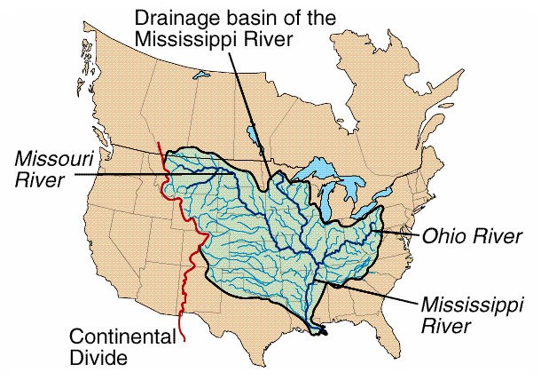
For those wondering what the drainage basin for the Mississippi River is, here you go. Any rain and snow that falls/melts in this area passes through Baton Rouge.
Posted on 2/25/19 at 1:40 pm to TDsngumbo
quote:
TDsngumbo
I'm gonna be "that guy" here.
Technically, I don't think the Red River is a tributary of the Mississippi. Water flowing into the Red basically flows down the Atchafalaya at Old River, unless I am wrong. That water does not flow past Baton Rouge, and the water of the Red puts no additional strain on the Mississippi downriver.
I say this because I puzzled over why I never crossed the Red when I drove up Highway 15 toward Natchez. I finally figured out it does not really flow into the Mississippi.
I'm not a hydrologist, and I've been known to read maps wrong. But I think that is right.
This post was edited on 2/25/19 at 1:42 pm

Posted on 2/25/19 at 1:44 pm to White Roach
quote:
If we'll probably lose anyway, how does spending billions to buyout and relocate about 1/2 of the state's population make more sense than just continueing with the levee systemm and delaying the inevitable?
A study of the history of Mankind reveals numerous mass abandonment of settled areas. It happens over and over and over and will happen again.
There is a near-certainty it happens in S La at some point.

 Page 16 of 107

Popular
Back to top