- My Forums
- Tiger Rant
- LSU Recruiting
- SEC Rant
- Saints Talk
- Pelicans Talk
- More Sports Board
- Fantasy Sports
- Golf Board
- Soccer Board
- O-T Lounge
- Tech Board
- Home/Garden Board
- Outdoor Board
- Health/Fitness Board
- Movie/TV Board
- Book Board
- Music Board
- Political Talk
- Money Talk
- Fark Board
- Gaming Board
- Travel Board
- Food/Drink Board
- Ticket Exchange
- TD Help Board
Customize My Forums- View All Forums
- Show Left Links
- Topic Sort Options
- Trending Topics
- Recent Topics
- Active Topics
Started By
Message
re: More Severe Weather for the Southeast: January 11-12, 2024
Posted on 1/11/24 at 11:58 am to LegendInMyMind
Posted on 1/11/24 at 11:58 am to LegendInMyMind
Yea they shifted everything eastward which honestly makes more sense to me but also sounds like the tornado chance has decreased somewhat
I'm honestly not sure it calls for "enhanced" but they are way smarter than me
I'm honestly not sure it calls for "enhanced" but they are way smarter than me
 2
2


Posted on 1/11/24 at 12:15 pm to Wishnitwas1998
quote:
I'm honestly not sure it calls for "enhanced" but they are way smarter than me
The enhanced is based on the probabilities of severe level straight line winds.
Posted on 1/11/24 at 12:45 pm to Wishnitwas1998
Yeah, it is wind-driven with a 30% hatched area. Gonna be another windy day, even without the storms.
Posted on 1/11/24 at 12:58 pm to Roll Tide Ravens
quote:
They’ve lessened the tornado threat, t
And of course right on cue my local news weather app sends a notification saying the chances of tornadoes have increased
shite like this is why so many people
Bitch in these threads bc there absolutely are outlets out there that try to exaggerate things for views

Posted on 1/11/24 at 12:59 pm to LegendInMyMind
Does this mean it is likely to arrive later on the east coast and stay longer, or keep the same timing and just be less severe?
Posted on 1/11/24 at 1:09 pm to PsychTiger
Not much has changed timing-wise for the east coast.
Posted on 1/11/24 at 1:53 pm to Roll Tide Ravens
Whoa, what a massive change in target areas.
I've never seen that big of a change within a day of said event
I've never seen that big of a change within a day of said event

Posted on 1/11/24 at 1:58 pm to LegendInMyMind
quote:
A weird, pain in the arse system this one is.
I read this in Yoda's voice.
Posted on 1/11/24 at 2:05 pm to SouthEndzoneTiger
With the serious single digit lows that are being predicted for several fronts coming through east Tennessee, my landscaping has a chance of surviving if it goes in well watered.
Posted on 1/11/24 at 2:14 pm to East Coast Band
quote:
Whoa, what a massive change in target areas.
I've never seen that big of a change within a day of said event
Tough forecast, but SPC accounted for this possibility, at least to an extent. Instability, or the lack thereof, has been the big question mark. What was already a question mark has trended down with each run of the CAMs. Moisture isn't terrible for this time of year, and lapse rates aren't bad, but CAPE (especially low level) is virtually nonexistent across much of the original area of concern. Shear isn't an issue, either. There will be a massive LLJ that kicks early tomorrow, but it is a bit displaced, which probably figures into the big shift in tomorrow's enhanced area.
Posted on 1/11/24 at 2:31 pm to LegendInMyMind
@NWSHuntsville
They corrected the day on the timing graphic in a follow up tweet.
@NWSBirmingham
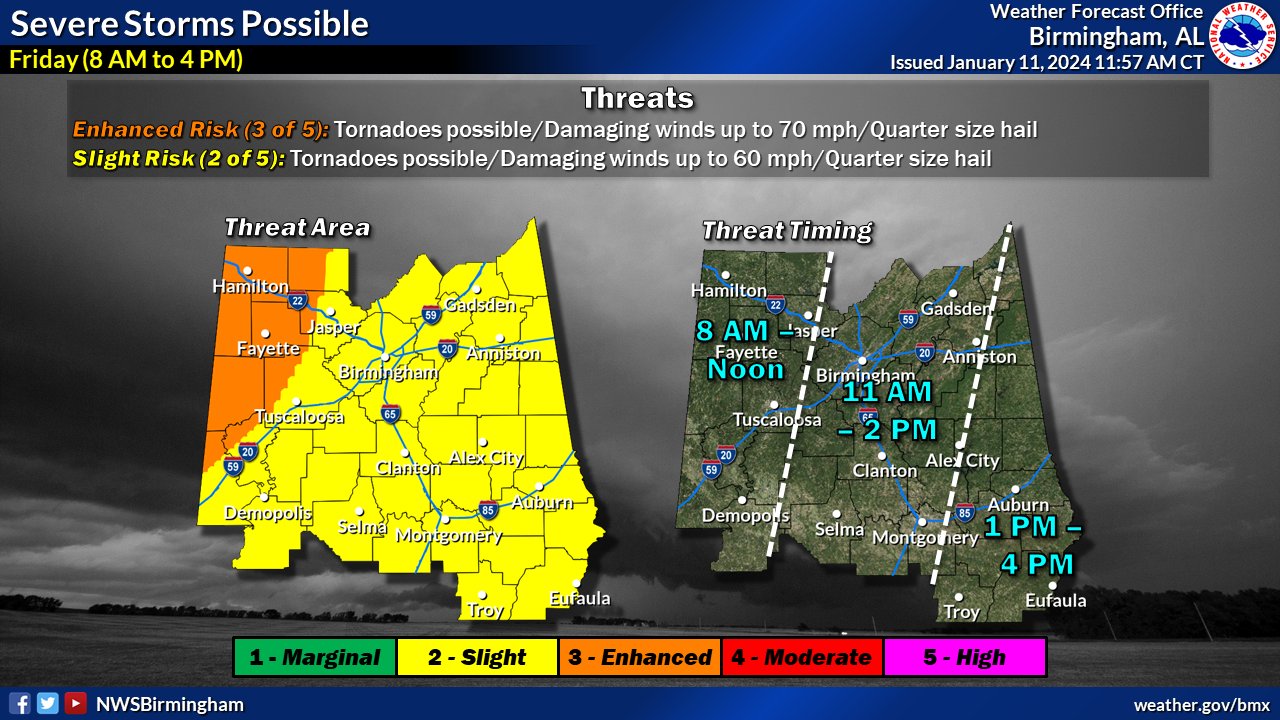
quote:
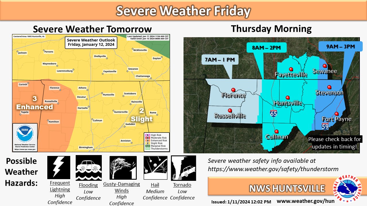
SEVERE WEATHER POTENTIAL TOMORROW
SPC has upgraded our whole area to a Slight Risk with NW AL in an Enhanced Risk for severe weather tomorrow.
Thunderstorms capable of producing damaging winds of 75+ MPH are possible. Make sure to have multiple ways to receive warnings!
They corrected the day on the timing graphic in a follow up tweet.
@NWSBirmingham
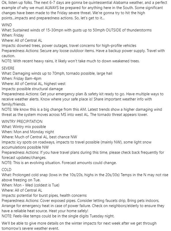
quote:
Here's the latest on the Severe, Winter, and Cold impacts expected over the next 7 days. Please read it in it's entirety and TAKE ACTION to prepare! LOOK at all attached graphics as they will help answer any questions you may have.
Posted on 1/11/24 at 5:41 pm to LegendInMyMind
Good to see that West Central GA.has been downgraded to a level 2. People here(understandably) were getting antsy considering that tomorrow is the year anniversary of the Griffin tornadoes.
This post was edited on 1/11/24 at 7:23 pm
Posted on 1/11/24 at 5:54 pm to SteelerBravesDawg
Looks like we have a window for some nastiness in the Arklatex area starting in a couple hours or so. Maybe a chance for a tornado or two, especially in the western part of the area. Instability kind of falls off as you move east, though. This will likely be a big wind bag for MS and AL where we just don't have the CAPE or moisture to really support tornadic storms. The straight line winds are gonna be hairy, and the gradient winds will be similar to the other day.
This post was edited on 1/11/24 at 9:18 pm
Posted on 1/11/24 at 6:58 pm to LegendInMyMind
Posted on 1/11/24 at 7:01 pm to lachellie
Will pickle ball be cancelled because that’s I’m all I’m really worried about.
Posted on 1/11/24 at 8:27 pm to lachellie
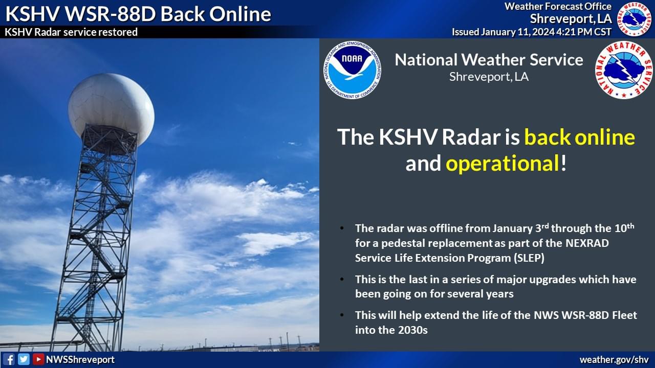
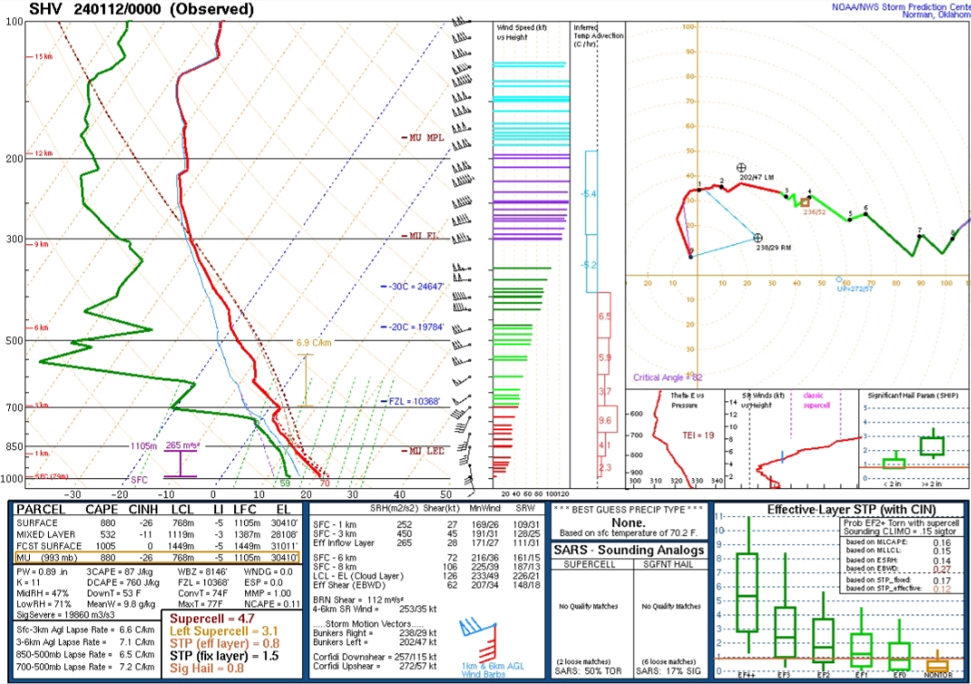
Not the worst observed sounding out of Shreveport ahead of storm development.
Posted on 1/11/24 at 8:44 pm to LegendInMyMind
Tuscaloosa County schools are canceled for tomorrow. Or should I say it's been changed to a "e- learning" day.

Posted on 1/11/24 at 8:59 pm to LegendInMyMind
ELI5 please?
Posted on 1/11/24 at 9:12 pm to East Coast Band
Yeah, same for some family I have in Blount county.
Posted on 1/11/24 at 9:15 pm to lachellie
quote:
ELI5 please?
Basically supports my thinking in my previous post about the storms tonight. It is a bigger deal if some storms form out ahead or the line that will be moving out of Texas into the Arklatex. There will be a good environment for those storms.
The storms over Arkansas now are elevated and are mostly a hail threat. What may form later farther south will be more surface based and in a better environment.
This post was edited on 1/11/24 at 9:17 pm

 Page 5 of 9

Popular
Back to top