- My Forums
- Tiger Rant
- LSU Recruiting
- SEC Rant
- Saints Talk
- Pelicans Talk
- More Sports Board
- Fantasy Sports
- Golf Board
- Soccer Board
- O-T Lounge
- Tech Board
- Home/Garden Board
- Outdoor Board
- Health/Fitness Board
- Movie/TV Board
- Book Board
- Music Board
- Political Talk
- Money Talk
- Fark Board
- Gaming Board
- Travel Board
- Food/Drink Board
- Ticket Exchange
- TD Help Board
Customize My Forums- View All Forums
- Show Left Links
- Topic Sort Options
- Trending Topics
- Recent Topics
- Active Topics
Started By
Message
re: Major Severe Weather Outbreak: March 14-16, 2025
Posted on 3/15/25 at 5:24 pm to Roll Tide Ravens
Posted on 3/15/25 at 5:24 pm to Roll Tide Ravens
Thats the one im concerned with, being in bessemer
 0
0

Posted on 3/15/25 at 5:24 pm to LegendInMyMind
Shoals warning kinda came out of no where
Did NWS Memphis forget that isn't their area?
Did NWS Memphis forget that isn't their area?
Posted on 3/15/25 at 5:26 pm to Wishnitwas1998
quote:
Shoals warning kinda came out of no where
Did NWS Memphis forget that isn't their area?
That's Huntsville. It spun up quickly. By the time the warning came out, and with next radar loop, it had gusted out.
Posted on 3/15/25 at 5:26 pm to Roll Tide Ravens
Damage in Cave City, AR from a tornado last night. NWS Little Rock has preliminary rated it a very high end EF3.
Posted on 3/15/25 at 5:27 pm to alphaandomega
quote:
Spann said that the rain and cooler temperatures is making atmosphere more stable.
This is awesome news.
I was looking at the dewpoints for my neck of the woods when the storms move in, they will be 58 when they first start moving in but inch to 60/61 by the time the heart of the system moves in. 60 is the magic number for severe weather. 65 is the absolute drop-dead number. So hopefully it won't be bad.

Posted on 3/15/25 at 5:27 pm to alphaandomega
Cell North of Jasper, near Arley looks like one to keep an eye on

Posted on 3/15/25 at 5:30 pm to RazorBroncs
quote:
Cell North of Jasper, near Arley looks like one to keep an eye on
Yeah, I won’t be surprised if that gets a warning soon.
Posted on 3/15/25 at 5:31 pm to Roll Tide Ravens
It's getting worse each scan
Posted on 3/15/25 at 5:36 pm to RazorBroncs
Debris fallout from the Gordo tornado is still showing up SW of Arley. That's what it seems to be, anyway.
This post was edited on 3/15/25 at 5:37 pm

Posted on 3/15/25 at 5:36 pm to RazorBroncs
Sumter county warning cancelled
No active warnings in west central Alabama or Mississippi
No active warnings in west central Alabama or Mississippi
Posted on 3/15/25 at 5:37 pm to RazorBroncs
I can’t believe B’ham hasn’t issued a warning for the Arley/Addison storm.
Posted on 3/15/25 at 5:37 pm to LegendInMyMind
Ahh, if that's the case then it makes more sense for that not to be warned. Because it's looking rough
ETA: nevermind there's the warning
ETA: nevermind there's the warning
This post was edited on 3/15/25 at 5:39 pm
Posted on 3/15/25 at 5:38 pm to Roll Tide Ravens
They just issued a warning for the Arley storm.
Posted on 3/15/25 at 5:39 pm to Roll Tide Ravens
It makes me feel much better for the safety of my family that I'm getting better at this, thanks for the suggestion on WeatherWise earlier Legend
Posted on 3/15/25 at 5:41 pm to RazorBroncs
quote:
Ahh, if that's the case then it makes more sense for that not to be warned. Because it's looking rough
ETA: nevermind there's the warning
It still needed the warning, but the original funky stuff on CC was lofted debris fallout (I think).
This post was edited on 3/15/25 at 5:44 pm
Posted on 3/15/25 at 5:43 pm to LegendInMyMind
Looks like it's wrapping up pretty high in the atmosphere now. That might be a legitimate tornado soon, if not already
Posted on 3/15/25 at 5:44 pm to RazorBroncs
It is so hard to tell because it is between two radars. We're seeing the higher parts of the storm.

Posted on 3/15/25 at 5:45 pm to Roll Tide Ravens
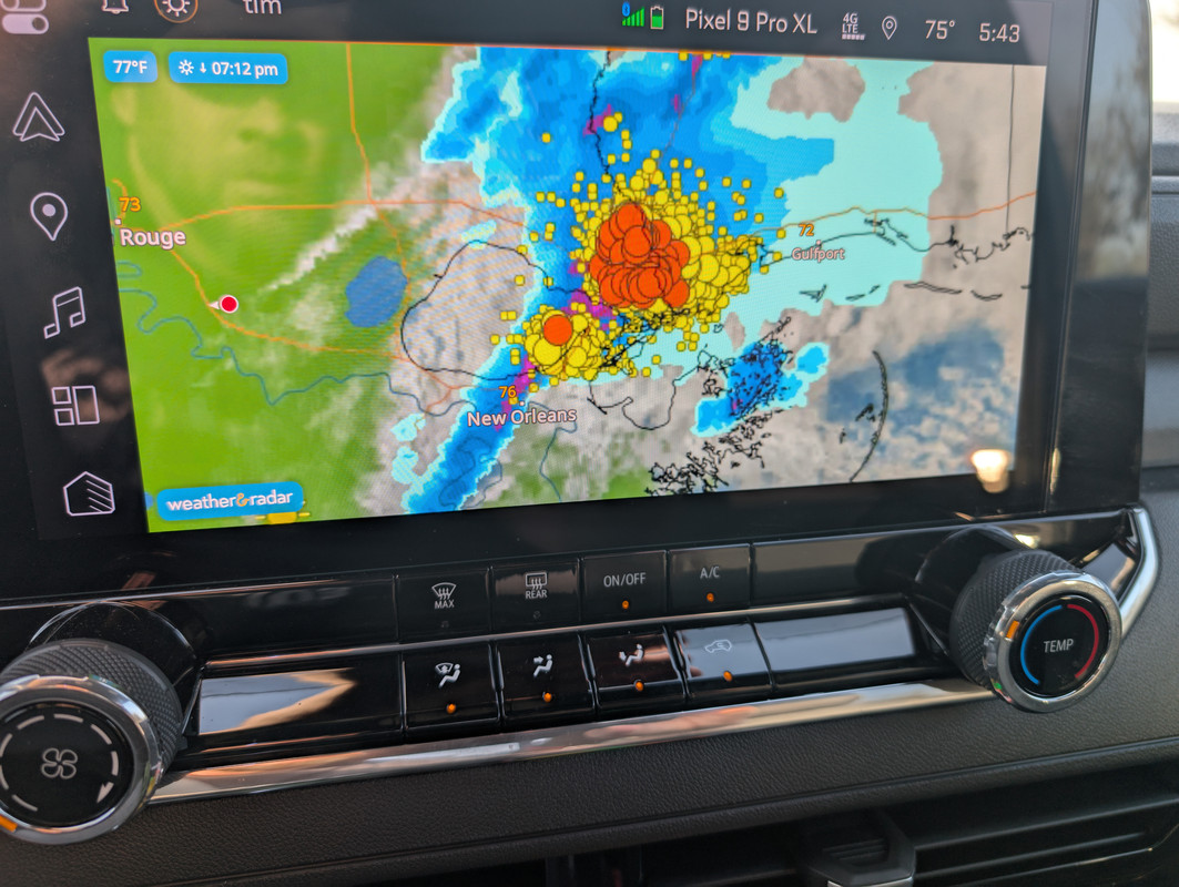
Not sure what the Oranges and lemons are. Whatever they are Slidell is getting Pelted with them
Posted on 3/15/25 at 5:45 pm to Higgysmalls
I don't know what all that business is, either.
Posted on 3/15/25 at 5:45 pm to LegendInMyMind
quote:
DI’d I read correctly that if it rains beforehand that it chokes off some energy for a tornado? Not always. 4/27/11 for example.
I remember 4/27 we would get a supercell with a warming, it would rain, then the sun came out and it just made it more hot and humid from the rain.
The setup that day was unbelievable. Never seen anything like it
I remember watching the sky go from sunny to black in 10 minutes, sirens would go off, and you could watch the rain rotate. It would rain for 10 seconds then rotate away counter clockwise and then come back around again. It was weird
I have a video of it on my old blackberry phone I need to figure out how to upload it off there if I ever find the old phone

 Page 69 of 88

Popular
Back to top