- My Forums
- Tiger Rant
- LSU Recruiting
- SEC Rant
- Saints Talk
- Pelicans Talk
- More Sports Board
- Fantasy Sports
- Golf Board
- Soccer Board
- O-T Lounge
- Tech Board
- Home/Garden Board
- Outdoor Board
- Health/Fitness Board
- Movie/TV Board
- Book Board
- Music Board
- Political Talk
- Money Talk
- Fark Board
- Gaming Board
- Travel Board
- Food/Drink Board
- Ticket Exchange
- TD Help Board
Customize My Forums- View All Forums
- Show Left Links
- Topic Sort Options
- Trending Topics
- Recent Topics
- Active Topics
Started By
Message
 0
0


Posted on 3/13/16 at 6:32 pm to Scoop
They didn't see this debris ball:

Posted on 3/13/16 at 6:33 pm to Scoop
Ascension P schools closed tomorrow.
Posted on 3/13/16 at 6:36 pm to dukke v
quote:
My bro-in-law lives in Head Of Island on old river road and says water is rising in the whole area. He went out this morning to get supplies but they said that's it if you stay you ride it out... His house is way off the ground but his garage is pretty low... Anyone with a camp in that area may want to get it checked if you can...Its not the rain. Its the water is flowing downstream and there is nowhere else for it to go....
Well I guess my parents camp on Old River Rd will prob be under as well. Sucks bc my dad just replaced the roof about 2 months ago.
Posted on 3/13/16 at 6:36 pm to JOHNN
Tornado trying to form in Grady
Posted on 3/13/16 at 6:37 pm to Scoop
Storms giving it another go in N. Louisiana
Posted on 3/13/16 at 6:39 pm to rds dc

Posted on 3/13/16 at 6:43 pm to rds dc
Thanks for the heads up. They seem to be forming in North La but not finding their legs until they get into South ark. That cell above the corridor between Magnolia and El Dorado looks angry.
Posted on 3/13/16 at 7:18 pm to rds dc
Same thing. Arkansas event so far. I'm assuming we are good in NWLA with the sun going down.
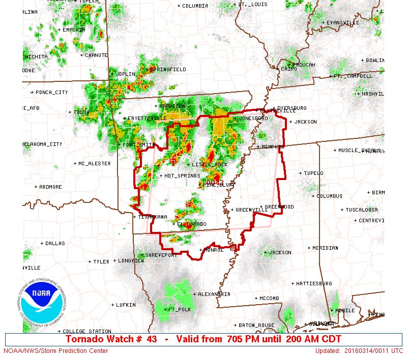
Posted on 3/13/16 at 8:24 pm to Scoop
Cell west of Monroe is Svr Warned and needs to be watched
ETA: Tor Warned cells moving into Memphis area
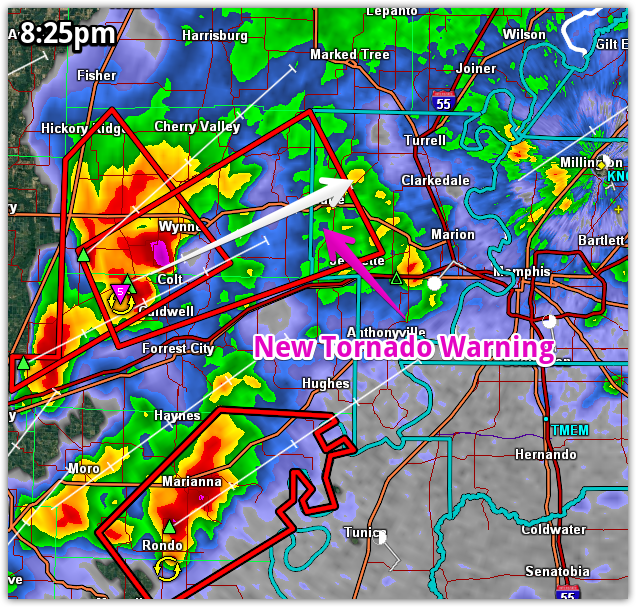
ETA: Tor Warned cells moving into Memphis area
This post was edited on 3/13/16 at 8:31 pm

Posted on 3/13/16 at 8:34 pm to Scoop
Jones Creek at the crossing in White Oak Landing is the highest I've ever seen it. It's about to overtop the bridge and its rising above the level of the two lakes next to it. Water is starting to cross Woodlake Dr before the bridge. I drove back to those houses next to where Jones Creek meets the Amite River and the water has risen up to the cup-de-sac on Creek Round Ave.

Posted on 3/13/16 at 8:38 pm to The Boat
You think Jones Creek is going to flood on the Jones Creek Road Bridge? Last time I remember that happening was '83 I think, and it's looking very high today.
Posted on 3/13/16 at 8:45 pm to rds dc
KNOE just reported a dam or levee broke in Richland parish, and that Hebert could be getting 2-4 feet of water
Posted on 3/13/16 at 8:54 pm to Festus
Not on Jones Creek. They raised that bridge when they widended the road. It could overtop on Wooklake Drive. It was almost touching the bridge when I drove by this evening. It'll start going down as the Amite starts dropping.
The Amite crested three feet lower than they thought it would a couple of days ago. If it ever gets around 39 feet it'll be way over the Woodlake Dr bridge.
The Amite crested three feet lower than they thought it would a couple of days ago. If it ever gets around 39 feet it'll be way over the Woodlake Dr bridge.
This post was edited on 3/13/16 at 8:58 pm
Posted on 3/13/16 at 8:58 pm to KillTheGophers
quote:
All the drama now is at West Elmwood and the pump / new levee at Forsythe Extension.
so i assume this is why my rent house in Northside Terrace just flooded??
Posted on 3/13/16 at 9:00 pm to rds dc
Unfortunately, looks like more flooding rain in NE Louisiana tonight

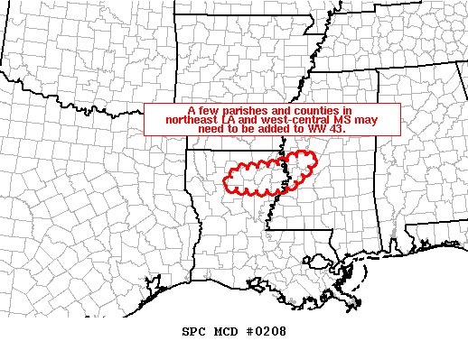
Looks like Tornado Watch is going to expanded south to cover more of Louisiana
quote:
MESOSCALE PRECIPITATION DISCUSSION 0087
NWS WEATHER PREDICTION CENTER COLLEGE PARK MD
947 PM EDT SUN MAR 13 2016
AREAS AFFECTED...E ARKANSAS...SW TENNESSEE...NW MISSISSIPPI...NE
LOUISIANA
CONCERNING...HEAVY RAINFALL...FLASH FLOODING POSSIBLE
Looks like Tornado Watch is going to expanded south to cover more of Louisiana
Posted on 3/13/16 at 9:15 pm to rds dc
NWS Shreveport ?@NWSShreveport 9m9 minutes ago
DAM BREAK REPORTED ON BAYOU LAFOURCHE BORDERING CALDWELL AND RICHLAND PARSH. WATER FLOWING RAPIDLY TOWARDS HEBERT !!! EVACUATE HEBERT NOW !
DAM BREAK REPORTED ON BAYOU LAFOURCHE BORDERING CALDWELL AND RICHLAND PARSH. WATER FLOWING RAPIDLY TOWARDS HEBERT !!! EVACUATE HEBERT NOW !
Posted on 3/13/16 at 9:25 pm to rds dc
How big is the dam up there, and how much water is expected?
Posted on 3/13/16 at 9:26 pm to Hammertime
quote:
How big is the dam up there, and how much water is expected?
Don't know, haven't seen many details other than there was a dam break.

 Page 88 of 102

Popular
Back to top