- My Forums
- Tiger Rant
- LSU Recruiting
- SEC Rant
- Saints Talk
- Pelicans Talk
- More Sports Board
- Fantasy Sports
- Golf Board
- Soccer Board
- O-T Lounge
- Tech Board
- Home/Garden Board
- Outdoor Board
- Health/Fitness Board
- Movie/TV Board
- Book Board
- Music Board
- Political Talk
- Money Talk
- Fark Board
- Gaming Board
- Travel Board
- Food/Drink Board
- Ticket Exchange
- TD Help Board
Customize My Forums- View All Forums
- Show Left Links
- Topic Sort Options
- Trending Topics
- Recent Topics
- Active Topics
Started By
Message
re: Louisiana Ice Storm Thread *Winter Storm Warning*
Posted on 2/10/21 at 10:19 am to TDTOM

Posted on 2/10/21 at 10:19 am to TDTOM
quote:
How does it not snow if it is 15 and raining?
Snow forms higher up in the atmosphere and requires just the right conditions. It's not just a matter of temperature and water. It's temperature and pressure and wind and all kinds of other things that have to be just right to let snow form. A little outside the right conditions and snow won't happen, so you get other kinds of winter precipitation.
Snow forms in the higher cold air and falls to the ground. I think this setup has a cold layer at the bottom, a slightly warmer layer above that, then another col layer at the top. So, the snow forms high up, falls down through the warmer air where it melts, then turns into sleet and freezing rain as it falls through the cold air at the bottom (where it is no longer able to form snow).
This post was edited on 2/10/21 at 10:21 am
 1
1

Posted on 2/10/21 at 10:19 am to TDsngumbo


Posted on 2/10/21 at 10:20 am to DVinBR
I want it to be apocalyptically cold so I hope GFS is accurate
Posted on 2/10/21 at 10:25 am to TigerstuckinMS
quote:
Snow forms higher up in the atmosphere and requires just the right conditions. It's not just a matter of temperature and water. It's temperature and pressure and wind and all kinds of other things that have to be just right to let snow form. A little outside the right conditions and snow won't happen, so you get other kinds of winter precipitation.
Snow forms in the higher cold air and falls to the ground. I think this setup has a cold layer at the bottom, a slightly warmer layer above that, then another col layer at the top. So, the snow forms high up, falls down through the warmer air where it melts, then turns into sleet and freezing rain as it falls through the cold air at the bottom (where it is no longer able to form snow).
Makes sense.

Posted on 2/10/21 at 10:25 am to DVinBR
-6 in Shreveport would be incredible

Posted on 2/10/21 at 10:26 am to lesgeaux
quote:
Is GFS trustworthy? Idk how it can be saying 10 degrees in BR Tuesday morning and all the local weather forecasts and iPhone apps say 26
Weather apps are behind model runs. I think they also wait for multiple models to start saying the same thing before updating their forecast
Posted on 2/10/21 at 10:27 am to lesgeaux
12z GFS is trending colder if you can believe that and calling for a better chance of snow come Tuesday and Thursday.

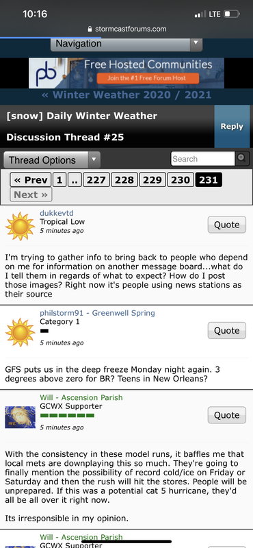
Posted on 2/10/21 at 10:30 am to crazyLSUstudent
Who did this??? 
Posted on 2/10/21 at 10:31 am to purple18
Peej, or someone representing as Peej, is all over the Stormcast board.
Posted on 2/10/21 at 10:32 am to TDsngumbo
So much denial and confusion
quote:
000
FXUS64 KLIX 101021
AFDLIX
AREA FORECAST DISCUSSION
National Weather Service New Orleans LA
421 AM CST Wed Feb 10 2021
.SHORT TERM (Today through Friday)...
Current upper level analysis shows zonal flow across the eastern
half the country with a trough south of California and high pressure
draped across Florida and portions of the Gulf of Mexico. This setup
has been and will continue to produce muggy and warm conditions
locally. Low/mid clouds seem to be winning out over fog at the
moment but still have some opportunity before sunrise. Thus will be
keeping dense fog advisory in effect until mid morning. If nothing
develops by 7am, will be canceling early. The fcst temps are a
degree or so above NBM based on the typical(and observed yesterday)
trend of NBM missing airmass moderation rate. Expect another day
with highs 10 to 15 degrees above normal. Ample moisture already in
place combined with a weak stalled front draped across central LA
will be all thats needed to spark convection today. Model soundings
shows mild/modest CAPE means at the least will have thunderstorms
develop. Wetbulb zero of around 10kft means there`s some possibility
that a few storms produce hail. Thinking SPS type storms mostly with
the low probability of needing a severe warning.
Moving into Thursday, the trough currently located southwest of CA
will track eastward into southern Texas while a more broad trough in
Canada expands south. This will cause the front in central Louisiana
to slowly push south into the CWA. Expect nearly 100% coverage with
a mix of showers and thunderstorms. Some areas could see an inch or
2 of rainfall throughout the day. This will be the last day of above
normal temps for awhile. Cooler air pushing in behind the front will
keep highs on Friday down to low 50s and low 60s. Lingering showers
will likely persist through probably early afternoon before finally
shifting south and east.
MEFFER
&&
.LONG TERM (Saturday through Tuesday)...
This portion of the forecast continues to be the most challenging
for a couple reasons. Those being frozen precip potential and
terrible model consistency. In nearly 15 years of forecasting, I
can`t remember a time when guidance changed so drastically. The
culprit is models trying to resolve weaker shortwaves with broad
troughing with bitter cold situated to the north. Don`t feel like
there`s much question that it will precip over the CWA at some point
this weekend and into early next week. It`s just a matter of whether
the lower portions of the atmosphere will support anything frozen.
Looking at 1000-500mb thicknesses as well as model soundings, the
answer is no. If you look at the setup broadly, possibly, as
repeated reinforcements of cold air with rain potential will give you
some chance. But, if you look at the medium range models` forecast
track of the upper low early next week, its quite far north for what
typically produces frozen precip here. For those reasons, have
pulled SN/ZR from the forecast for now.
Posted on 2/10/21 at 10:34 am to TDsngumbo
This post was edited on 2/10/21 at 10:41 am
Posted on 2/10/21 at 10:35 am to DVinBR
I really wouldn't know what to do if it is 4 degrees. Do cars still start?
Posted on 2/10/21 at 10:36 am to CypressTrout10
Yall. Somebody come get the GFS and take it home


This post was edited on 2/10/21 at 10:38 am
Posted on 2/10/21 at 10:37 am to Lsuhoohoo
can someone link these models? I'm an actual moron and cannot find these temp models on troppicaltidbits
I'm trying to send these to my wife to freak her out
I'm trying to send these to my wife to freak her out
Posted on 2/10/21 at 10:38 am to TDsngumbo
12z CMC still holding the line

Lowest temp of 11F

Lowest temp of 11F

Posted on 2/10/21 at 10:38 am to Lsuhoohoo
Wind chill of -12 for LC!
Posted on 2/10/21 at 10:39 am to BallsEleven
This is nuts 
this would easily be the worst winter weather event to hit this state right?
this would easily be the worst winter weather event to hit this state right?

Posted on 2/10/21 at 10:40 am to Lsuhoohoo
Holy frick. I've been to Chicago in the winter and if this verifies it will be the coldest day I have ever experienced. And in Louisiana at that
This post was edited on 2/10/21 at 10:41 am
Posted on 2/10/21 at 10:41 am to DVinBR
Welp the ducks would finally be down in that case
Posted on 2/10/21 at 10:43 am to DVinBR
Don't like these models shifting things slowly east.

 Page 55 of 284

Popular
Back to top