




- My Forums
- Tiger Rant
- LSU Recruiting
- SEC Rant
- Saints Talk
- Pelicans Talk
- More Sports Board
- Fantasy Sports
- Golf Board
- Soccer Board
- O-T Lounge
- Tech Board
- Home/Garden Board
- Outdoor Board
- Health/Fitness Board
- Movie/TV Board
- Book Board
- Music Board
- Political Talk
- Money Talk
- Fark Board
- Gaming Board
- Travel Board
- Food/Drink Board
- Ticket Exchange
- TD Help Board
Customize My Forums- View All Forums
- Show Left Links
- Topic Sort Options
- Trending Topics
- Recent Topics
- Active Topics
Started By
Message
re: Laura - President Trump visits Lake Charles, Louisiana for Hurricane Response Update
Posted on 8/24/20 at 12:38 am to fightin tigers

Posted on 8/24/20 at 12:38 am to fightin tigers
quote:
Does earlier organization play into it becoming a stronger storm or is it really a crap shoot?
The earlier it organizes, the more time it will have to take advantage of the conditions over the Gulf. So yeah, a stronger and more organized storm as it exits Cuba would yield a stronger system down the line.
 2
2

Posted on 8/24/20 at 12:47 am to Duke
Any idea on projections if the organization shifts south like was posted?


Posted on 8/24/20 at 12:50 am to Duke
quote:
The earlier it organizes, the more time it will have to take advantage of the conditions over the Gulf. So yeah, a stronger and more organized storm as it exits Cuba would yield a stronger system down the line.
I understand this but the steering currents still would potentially steer it as the models suggest, no?
I've also seen outliers saying what's left of Marco could settle down in the gulf near Brownsville or possibly not that far south but given the rotation of these systems, that rotation could potentially drive it Laura more north, instead of heading further to the west. I'm just trying to understand why the NHC had Laura heading toward Houston earlier this morning, then the track shifted east to Holly Beach/Cameron, to now even more east. Plus it isn't scheduled to make a landfall for another 2 days. I appreciate your info. I understand no track is set in stone but after going through 3 cat 3s in Florida, I started studying what steers these systems but with this being two, forecast to make landfall within days of each other, it's hard to pinpoint it down. If you get one wrong, it's easy to get the other one wrong. Even Marco's track is still uncertain. It's pretty close to what I think it'll be but it's not definitive. I understand about the high pressure that's supposed to drive Laura west but like I said, they have now changed those tracks. What's your take on that? Really asking.
Posted on 8/24/20 at 12:54 am to fightin tigers
It's more open water to work with, so it should allow greater organization. A farther south launch and more organized system would tend to be farther west by the end.
I'm still in wait and see mode (more like see what it looks like in the morning) on any potential southern center moves.
I'm still in wait and see mode (more like see what it looks like in the morning) on any potential southern center moves.
Posted on 8/24/20 at 1:07 am to la_birdman
quote:
I understand about the high pressure that's supposed to drive Laura west but like I said, they have now changed those tracks. What's your take on that?
You sort of answer your own question earlier. The track is really uncertain because of
A) Questions of organization and location coming into the Gulf.
B) Exact shape of the ridge and how far it pushes in. (This won't make for huge changes but little differences can yield huge impacts for individual communities)
C) Possible Marco leftover interactions
It's complex to the point there's still wide range of possible outcomes. To the point those with far more understanding and experience than I have aren't able to really nail it down.
The NHC path is basically just following their consensus model (basically a weighted average of all the good models' paths). The problem is the envelope of possibilities is so wide still that each run of a model just shows you one of the possible outcomes.
So the NHC path has jumped around some but in reality nothing has changed. New Orleans is still a remote possibility. Corpus Christi is still a remote possibility.
The good thing is Marco is falling apart tonight and should follow the projected path well as a weak TS/TD and eventually an open low that moves west.
Still opens the door for some weird interactions, but that's just one of the questions we still need to answer.
Which is frustrating with a likely major hurricane strike just a few days out and major population centers in the potential path.
Posted on 8/24/20 at 1:10 am to Duke
Euro trended back west at the 00z run, back to TX/LA border
Posted on 8/24/20 at 1:12 am to Lion4Life
quote:
Euro trended back west at the 00z run, back to TX/LA border

Looks like the EURO jumped (back) on the SWLA train.
Edit: looking at another forum, it looks like this is first time ICON, GFS, CMC, and now the EURO have seemed to have some agreement on Laura's projected path. I guess we'll see if it holds.

This post was edited on 8/24/20 at 1:14 am

Posted on 8/24/20 at 1:12 am to Lion4Life

Posted on 8/24/20 at 1:14 am to Duke
quote:
Still opens the door for some weird interactions, but that's just one of the questions we still need to answer.
Which is frustrating with a likely major hurricane strike just a few days out and major population centers in the potential path.
Thank you. That was my take on it as well. Just wanted to make sure I wasn't completely wrong with my thinking on this. Appreciate your input.

Posted on 8/24/20 at 1:14 am to Lion4Life
quote:
Euro trended back west at the 00z run, back to TX/LA border


Posted on 8/24/20 at 1:16 am to Lion4Life
quote:
Euro trended back west at the 00z run
The Euro I saw had it more east than the current track. Closer to Morgan City or Houma.
Was I looking at something different? Not trying to be condescending or anything. I'm really asking.
The GFS I saw had it more west but still not all the way to the TX/LA border. At least not what I saw at 10.

Posted on 8/24/20 at 2:04 am to tiger91
Out In Iowa.
Posted on 8/24/20 at 3:33 am to deuce985
It’s bullshite like that which is EXACTLY why I got a standby generator, a few years ago.

Posted on 8/24/20 at 3:51 am to RealityTiger
It looks like Marco took a detour to Florida.
Posted on 8/24/20 at 4:02 am to ell_13

Shift back over LC with the latest update.

Posted on 8/24/20 at 4:04 am to BallsEleven
Hate that for the LC folks but man I want this to keep up. The 10pm has me shitting bricks.
Posted on 8/24/20 at 4:14 am to CaptainJ47
quote:
The GFS and ECMWF models, along with the statistical and corrected-consensus models, only strengthen the cyclone to a peak intensity around 75 kt. In contrast, the HRWF and HMON models bring Laura to major hurricane strength by 60 hours. Given the very favorable environmental conditions of high SSTs near 31 deg C and low vertical shear values less than 10 kt after 24-36 hours, subsequent intensity forecasts might have to trend more toward the regional models. But for now, the official intensity forecast will continue to follow a blend of the regional and global model intensity forecasts, and lies at the high-end of the intensity guidance at 60 and 72 hours.
quote:
INIT 24/0900Z 20.8N 78.9W 55 KT 65 MPH
12H 24/1800Z 21.7N 81.5W 55 KT 65 MPH
24H 25/0600Z 22.9N 84.6W 60 KT 70 MPH
36H 25/1800Z 24.5N 87.6W 65 KT 75 MPH
48H 26/0600Z 26.1N 90.2W 75 KT 85 MPH
60H 26/1800Z 28.0N 92.3W 85 KT 100 MPH
72H 27/0600Z 29.8N 93.3W 90 KT 105 MPH
96H 28/0600Z 35.4N 91.5W 35 KT 40 MPH...INLAND
120H 29/0600Z 37.6N 82.1W 25 KT 30 MPH...POST-TROP/REMNT LOW
This post was edited on 8/24/20 at 4:16 am
Posted on 8/24/20 at 4:35 am to BallsEleven

Marco looks to be a rain maker along the coast.
This post was edited on 8/24/20 at 4:37 am


Posted on 8/24/20 at 4:35 am to BallsEleven
quote:
72H 27/0600Z 29.8N 93.3W 90 KT 105 MPH
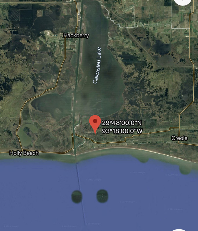
Right at the mouth of Big Lake


Posted on 8/24/20 at 4:42 am to Prominentwon
Damn it

 Page 202 of 815

Popular
Back to top
 Follow TigerDroppings for LSU Football News