- My Forums
- Tiger Rant
- LSU Recruiting
- SEC Rant
- Saints Talk
- Pelicans Talk
- More Sports Board
- Fantasy Sports
- Golf Board
- Soccer Board
- O-T Lounge
- Tech Board
- Home/Garden Board
- Outdoor Board
- Health/Fitness Board
- Movie/TV Board
- Book Board
- Music Board
- Political Talk
- Money Talk
- Fark Board
- Gaming Board
- Travel Board
- Food/Drink Board
- Ticket Exchange
- TD Help Board
Customize My Forums- View All Forums
- Show Left Links
- Topic Sort Options
- Trending Topics
- Recent Topics
- Active Topics
Started By
Message
re: Ian Observation Thread (Storm Track and Radar inside)
Posted on 9/27/22 at 10:55 pm to Dexterous404
Posted on 9/27/22 at 10:55 pm to Dexterous404
My dad's place in Cape Coral, smaller canal just off the Bimini Canal (one of the main ones off the river).
This post was edited on 9/27/22 at 10:56 pm
 1
1

Posted on 9/27/22 at 10:56 pm to H2O Tiger
quote:
No, all the downvotes lol
For the record, the one upvote was from me.
Posted on 9/27/22 at 10:57 pm to RummelTiger
quote:
So a TS in the AM?
I actually think this is a short term issue, but might be a recurring thing until landfall.

Posted on 9/27/22 at 10:57 pm to Duke
Ian isn't making landfall in Louisiana so Rob Perillo is actually being level headed and not saying it's a CAT 5 everyone die Doomcane

Posted on 9/27/22 at 10:58 pm to The Boat
This radar image looks like it is holding on so far...

Posted on 9/27/22 at 10:58 pm to t00f
quote:
imgur
My preferred image uploader is imgbb.
You upload the photo. Set it when you want it to expire or delete. No login information or user information needed, for privacy. Also, it gives you the code for this website. You just have to get rid of the /URL handles and links.
Downside is that you can’t upload animated gifs, I think.
This post was edited on 9/27/22 at 11:01 pm

Posted on 9/27/22 at 10:58 pm to The Boat
Perillo is a bitch.
Posted on 9/27/22 at 10:59 pm to RummelTiger
His wind maps for Laura were next level doomcasting
Posted on 9/27/22 at 11:01 pm to Tarps99
quote:
My preferred image uploader is imgbb.
You upload the photo. Set it when you want it to expire or delete. No login information or user information needed.
Postimages.org is just like that except you don't have to select when you want it to expire if you don't want to, and you can do gifs.
Posted on 9/27/22 at 11:02 pm to NorthEndZone
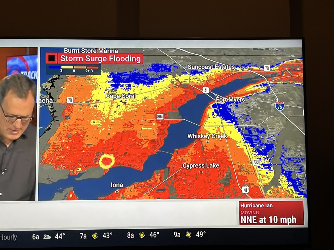
Key West water levels are finally dropping.
Peak was 4.27 feet above MLLW which was 2.09 feet above predicted high tide. Peak surge was only a few minutes before astronomical high tide.
NOAA Tides
Peak was 4.27 feet above MLLW which was 2.09 feet above predicted high tide. Peak surge was only a few minutes before astronomical high tide.
NOAA Tides
This post was edited on 9/27/22 at 11:04 pm

Posted on 9/27/22 at 11:03 pm to Chucktown_Badger
That's the uninsured one?
Posted on 9/27/22 at 11:04 pm to Tigernation1290
quote:
Better than the alternative which was looking like 150+
Why are you making stuff up. Nothing like this was ever forecasted.
Posted on 9/27/22 at 11:06 pm to The Boat

From the SW eyewall.

Posted on 9/27/22 at 11:06 pm to The Boat
quote:
Southeastern eye wall breached
Great news. Maybe it'll limit it, even weaken it a good bit.
Posted on 9/27/22 at 11:07 pm to H2O Tiger
quote:
That's the uninsured one?
Yes.

Posted on 9/27/22 at 11:11 pm to ILurkThereforeIAm
Did Key West evacuate?
Posted on 9/27/22 at 11:11 pm to Tigernation1290
quote:
storm weakening and looks like it will continue to weaken.
Nobody is saying that, nothing corroborates that, and you’re talking out of your arse.
It’s looking better for Tampa, but somewhere south of there will be fricked.
Posted on 9/27/22 at 11:12 pm to Chucktown_Badger
I don’t have a picture looking up toward the Bimini, but this is looking away from it. You can see the sea wall and then the house is maybe 3-4 feet up from that. I think the boat is hanging on davits, elevated out of the canal over that pad you can see to the right, and secured, but not enough if it’s truly 9 feet of surge. 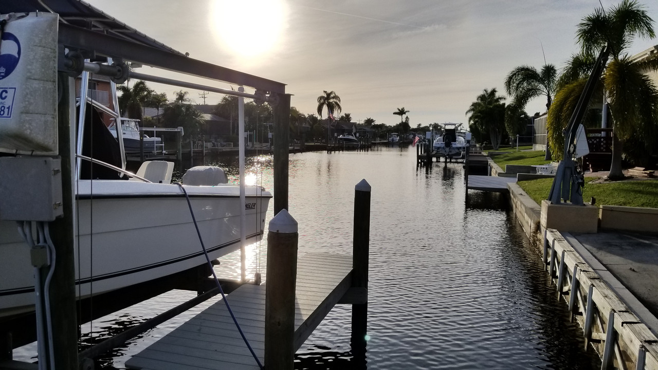
This post was edited on 9/27/22 at 11:15 pm
Posted on 9/27/22 at 11:15 pm to NorthEndZone
Water vapor looks impressive too. Still fending off Dry air at all levels.
College of Dupage Weather - Satellite Loop
College of Dupage Weather - Satellite Loop
This post was edited on 9/27/22 at 11:17 pm
Posted on 9/27/22 at 11:15 pm to SilvergunSuperman
GFS rainfall totals over the next 48 hours:


 Page 280 of 465

Popular
Back to top