- My Forums
- Tiger Rant
- LSU Recruiting
- SEC Rant
- Saints Talk
- Pelicans Talk
- More Sports Board
- Fantasy Sports
- Golf Board
- Soccer Board
- O-T Lounge
- Tech Board
- Home/Garden Board
- Outdoor Board
- Health/Fitness Board
- Movie/TV Board
- Book Board
- Music Board
- Political Talk
- Money Talk
- Fark Board
- Gaming Board
- Travel Board
- Food/Drink Board
- Ticket Exchange
- TD Help Board
Customize My Forums- View All Forums
- Show Left Links
- Topic Sort Options
- Trending Topics
- Recent Topics
- Active Topics
Started By
Message
re: Ian Observation Thread (Storm Track and Radar inside)
Posted on 9/27/22 at 10:36 pm to TchoupitoulasTiger

Posted on 9/27/22 at 10:36 pm to TchoupitoulasTiger
quote:
Might I suggest you subscribe to TDPremium. It’s a lot easier to post pics.
If you wait for the Black Friday Special, you also get Larry Leo's autograph.
 0
0

Posted on 9/27/22 at 10:37 pm to The Boat
quote:
quote:
“dramatic shift to the South”
This move has been telegraphed for a while now
Yes, correct. I just like his style of reporting and explaining and I thought others in my local area might appreciate it. I’ve watched him for years and he is very detailed and has always been absolutely spot on. Much better than the Sarasota weather guys.
This post was edited on 9/27/22 at 10:44 pm
Posted on 9/27/22 at 10:39 pm to OU Guy
Comcast’s network of public Xfinity WiFi hotspots throughout Central, North and Southwest Florida and the Panhandle are now available for anyone to use, including non-Xfinity customers, for free.
Learn more at
Xfinity LINK
Learn more at
Xfinity LINK
Posted on 9/27/22 at 10:40 pm to OU Guy
Best case scenario right now with the storm weakening and looks like it will continue to weaken.

Posted on 9/27/22 at 10:41 pm to FrankandBeans
quote:
I have family that are riding it out about 10 miles directly inland east of Venice. How worried should I be?

Posted on 9/27/22 at 10:42 pm to Tigernation1290
quote:
Best case scenario right now with the storm weakening and looks like it will continue to weaken.
I'd very much pump the breaks on that conclusion.
Posted on 9/27/22 at 10:42 pm to Duke
Guy on weather channel is saying eye wall replacement was shite and is weakening. Still will be strong but it’s not pushing cat 5 like it was potentially at first
Posted on 9/27/22 at 10:44 pm to Dexterous404
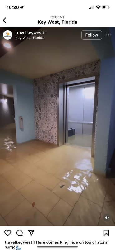
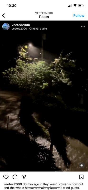
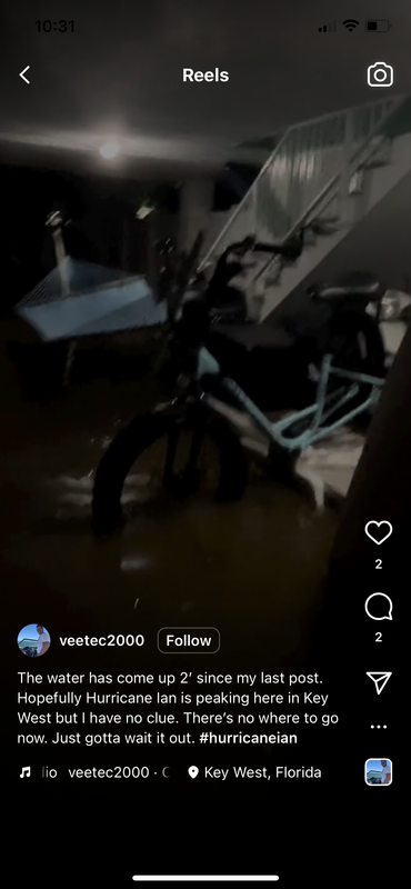
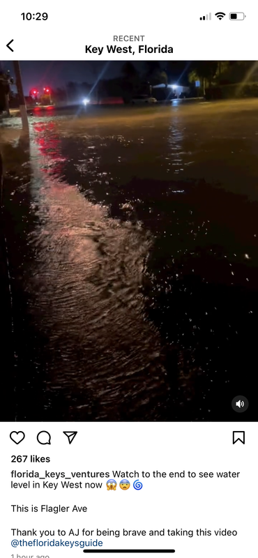
I went to Instagram and looked up recent posts geotagged in Key West. Here are a few screen shots I grabbed:
Posted on 9/27/22 at 10:45 pm to Tigernation1290
quote:
Guy on weather channel is saying eye wall replacement was shite and is weakening. Still will be strong but it’s not pushing cat 5 like it was potentially at first
Thanks for that. I had not heard that . I don’t have TWC so I appreciate the update!

Posted on 9/27/22 at 10:46 pm to Dexterous404
Youtube TV has it now
EDIT: That response was swift and angry
EDIT: That response was swift and angry
This post was edited on 9/27/22 at 10:49 pm

Posted on 9/27/22 at 10:49 pm to Tigernation1290
The latest official forecast from the NHC has it reaching max winds of 132 mph, with 160+ gusts.
125 at landfall with 155 gusts.
Winds are currently 120.
Weaker?
125 at landfall with 155 gusts.
Winds are currently 120.
Weaker?
Posted on 9/27/22 at 10:50 pm to RummelTiger
Better than the alternative which was looking like 150+
Let’s not forget the storm surge Tampa was facing that has drastically decreased. This is still gonna be rough but again best case scenario all things considered.
Let’s not forget the storm surge Tampa was facing that has drastically decreased. This is still gonna be rough but again best case scenario all things considered.
This post was edited on 9/27/22 at 10:53 pm

Posted on 9/27/22 at 10:52 pm to RummelTiger
The eye wall is trying to wrap back around. The storm is a pretty ugly presentation on radar right now. Fighting dry air wrapping in to the southern and western side hard. Major gaps in precip on those sides.
Posted on 9/27/22 at 10:52 pm to Tigernation1290
quote:
Better than the alternative which was looking like 150+
I don’t think anyone was calling for that.
You said getting weaker, not better than Cat 5.
It’s not forecasted, as of now, to be weaker than it currently is before landfall.
Posted on 9/27/22 at 10:53 pm to H2O Tiger
quote:
EDIT: That response was swift and angry
My response was? Not how I intended it at all. I was truly appreciative.
Posted on 9/27/22 at 10:53 pm to The Boat
2 mb rise between passes.
Posted on 9/27/22 at 10:53 pm to Dexterous404
No, all the downvotes lol
Posted on 9/27/22 at 10:54 pm to RummelTiger
quote:
The latest official forecast from the NHC has it reaching max winds of 132 mph, with 160+ gusts.
125 at landfall with 155 gusts.
Winds are currently 120.
Weaker?

- TWC
Posted on 9/27/22 at 10:54 pm to The Boat
quote:
The eye wall is trying to wrap back around. The storm is a pretty ugly presentation on radar right now. Fighting dry air wrapping in to the southern and western side hard. Major gaps in precip on those sides.
This, thanks.
Posted on 9/27/22 at 10:54 pm to Duke
So a TS in the AM?

 Page 279 of 465

Popular
Back to top