- My Forums
- Tiger Rant
- LSU Recruiting
- SEC Rant
- Saints Talk
- Pelicans Talk
- More Sports Board
- Fantasy Sports
- Golf Board
- Soccer Board
- O-T Lounge
- Tech Board
- Home/Garden Board
- Outdoor Board
- Health/Fitness Board
- Movie/TV Board
- Book Board
- Music Board
- Political Talk
- Money Talk
- Fark Board
- Gaming Board
- Travel Board
- Food/Drink Board
- Ticket Exchange
- TD Help Board
Customize My Forums- View All Forums
- Show Left Links
- Topic Sort Options
- Trending Topics
- Recent Topics
- Active Topics
Started By
Message
re: Ian Observation Thread (Storm Track and Radar inside)
Posted on 9/23/22 at 11:00 pm to AmosMosesAndTwins
Posted on 9/23/22 at 11:00 pm to AmosMosesAndTwins
GFS looking to miss Cuba and shoot the gap. 944mb as it approaches tip of Cuba
 2
2

Posted on 9/23/22 at 11:00 pm to GeauxLSUGRL
quote:
If you had a Florida beach trip next weekend would you cancel? Not sure what to do and tomorrow is my 3 day window
You should be fine. No rain but be prepared for double red flags all weekend. The rough surf usually lasts a few days after the storm makes landfall, even if that landfall is way south.
Posted on 9/23/22 at 11:01 pm to jlnoles79
quote:
2018 when Michael came through
Michael was as bad/worse as any. Good luck with Ian.
Posted on 9/23/22 at 11:02 pm to Hangit
quote:
If this comes through Bradenton, or Tampa, as a cat 4-5, the tree population will be decimated.
If that’s the case, hopefully it’s slightly south of Bradenton as that will spare the surge going into Tampa Bay.
Posted on 9/23/22 at 11:04 pm to Byrdybyrd05
quote:
I’m sure Tampa area will be a shite show tomorrow at hardware/grocery stores
Boarding up is a waste of time.
Posted on 9/23/22 at 11:06 pm to SippyCup
This GFS run has a monster

Posted on 9/23/22 at 11:06 pm to Hangit
quote:
Michael was as bad/worse as any. Good luck with Ian.
I feel fine for us right now with how it's tracking but I hate wishing storms on others

Posted on 9/23/22 at 11:09 pm to deltaland
quote:
GFS looking to miss Cuba and shoot the gap
worst case scenario there.
Posted on 9/23/22 at 11:10 pm to deltaland
little bit farther west by Cuba, but shows it getting influenced by the front more and hooks it harder east
eta: also weakens it significantly
eta: also weakens it significantly
This post was edited on 9/23/22 at 11:11 pm
Posted on 9/23/22 at 11:11 pm to deltaland
quote:
This GFS run has a monster
Upper levels are explosive, as has been mention before. Miss the land interaction and it'll get strong.
Posted on 9/23/22 at 11:14 pm to Duke
quote:
Miss the land interaction and it'll get strong.
the latest 11 pm NHC track has it going over Cuba
Posted on 9/23/22 at 11:19 pm to DVinBR
Good run by the GFS, shows it weakening significantly before landfalling as a TS

Posted on 9/23/22 at 11:41 pm to DVinBR
quote:
shows it weakening significantly before landfalling as a TS
Like to see that
Posted on 9/23/22 at 11:42 pm to Duke
Looks like the GFS backed off that stall a bit it had in previous runs.
Posted on 9/23/22 at 11:51 pm to mightynine
Here's an interesting note....
There's a hurricane about to make landfall with a 38° wind chill.
ETA: And I'm calling it a hurricane because Fiona fricking well earned it.
There's a hurricane about to make landfall with a 38° wind chill.
ETA: And I'm calling it a hurricane because Fiona fricking well earned it.
This post was edited on 9/23/22 at 11:56 pm

Posted on 9/23/22 at 11:57 pm to Duke
GFS has it increasing 50mb in like 36 hrs on approach to landfall.
That is some serious pucker factor for Tampa people.
Cat 4 heading toward to you and it comes in as tropical storm. Gah talk about.
Posted on 9/24/22 at 12:01 am to tgrgrd00
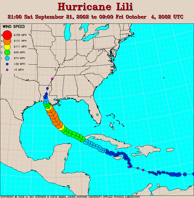
reminds me of Hurricane Lili, Cat 4 in the gulf only to landfall as barely a hurricane
Posted on 9/24/22 at 12:07 am to DVinBR
Pilippe doing what he does best.
@pppapin
Twitter with a really good graphic/gif
@pppapin
quote:
A full day GOES-16 water vapor loop shows the evolution of #Fiona completing a phase with a strong upper-level trough dropping out of Canada.
The hurricane's extratropical transition is complete marked by upper-level PV wrapping cyclonically around its core.
Remarkable event.
Twitter with a really good graphic/gif
Posted on 9/24/22 at 12:23 am to tgrgrd00
quote:
That is some serious pucker factor for Tampa people.
:fingerscrossed:
Posted on 9/24/22 at 12:38 am to DVinBR
quote:
Good run by the GFS, shows it weakening significantly before landfalling as a TS
That seems like a best case scenario for now. That run has some nasty rainfall totals but they’re all in the GOM. The same thing causing it to slow down and meander a bit is also tearing it apart with dry air intrusion on that run…


 Page 123 of 465

Back to top