- My Forums
- Tiger Rant
- LSU Recruiting
- SEC Rant
- Saints Talk
- Pelicans Talk
- More Sports Board
- Fantasy Sports
- Golf Board
- Soccer Board
- O-T Lounge
- Tech Board
- Home/Garden Board
- Outdoor Board
- Health/Fitness Board
- Movie/TV Board
- Book Board
- Music Board
- Political Talk
- Money Talk
- Fark Board
- Gaming Board
- Travel Board
- Food/Drink Board
- Ticket Exchange
- TD Help Board
Customize My Forums- View All Forums
- Show Left Links
- Topic Sort Options
- Trending Topics
- Recent Topics
- Active Topics
Started By
Message
re: Ian Observation Thread (Storm Track and Radar inside)
Posted on 9/22/22 at 11:13 pm to HeyCap
Posted on 9/22/22 at 11:13 pm to HeyCap
quote:
It’s a thread that non-weather nerds shouldn’t click on.
Do I have that right?
You have the right to Google any acronym you do not understand. You have the right to gain knowledge that is freely provided by the generous people provide their wisdom for free to anyone who wishes to consume such knowledge.
You do not have a right to absolute predictions that are not possible.
And you have the right to not act like a Karen.
 2
2


Posted on 9/22/22 at 11:18 pm to Bunta
quote:
GFS 9/23 00z is further south on Florida than the 9/22 18z run.
Yeah, and close to one of the previous Euro's too. You'll probably see the Euro correct to this location too. So Port Charlotte is looking like a spot I'd be seriously getting my hurricane supplies together before everything goes crazy tomorrow.

Posted on 9/22/22 at 11:21 pm to Oates Mustache
quote:
Port Charlotte
Very close to where Hurricane Charley made landfall in 2004. I will always remember Hurricane Charley made landfall in Punta Gorda, Florida because that's a fun name to say.
Posted on 9/22/22 at 11:24 pm to HeyCap
quote:
But can one of you start a thread, that in plain and understandable language simply discusses the potential landfall of said storms, like you’re Margaret Orr speaking to her pudding eating audience, but oh so much more accurate and without the drama!
I know that’s not as impressive or sexy to your weather loving buds, but it will reach a much larger audience than these posts do.
The problem is, right now, we're in the weeds with the discussion. Of course, you do have a point. If you're coming here for info and the talk is breaking down PV+ with convection...not super helpful.
Here's the big picture:
The most likely outcome is it gets turned into the Florida peninsula.
Less likely but still a reasonable scenario would have it miss the pull of the trough and get toward the northern Gulf Coast. This looks less likely tonight per the models but for some of those technical things discussed earlier, those runs might be too far east tonight.
Unless it takes a far east path over Cuba and into far southern Florida, this will probably be a major hurricane.
Does that help?
Posted on 9/22/22 at 11:25 pm to The Boat
It's no Punta Cana

Posted on 9/22/22 at 11:27 pm to Bunta
Best thing about this 00z gfs run is those Thursday morning temps 

Posted on 9/22/22 at 11:28 pm to Duke
quote:
Does that help?
Gotta communicate with the lay people. Once we get a storm with an agreeable track that's where I come in.
Gotta use gifs and culture references to help people understand what's going on.
Posted on 9/22/22 at 11:28 pm to deuce985
GFS has it cross Florida, strengthen a bit then landfall again Ga/SC line

Posted on 9/22/22 at 11:30 pm to lz2112
quote:
lz2112
Oooh, I got the Karen card from you. Now do Boomer, GenX, racists….etc.
Now take the time and, as you suggest, google the different meanings of the word “right”.
Posted on 9/22/22 at 11:32 pm to The Boat
quote:
Very close to where Hurricane Charley made landfall in 2004. I will always remember Hurricane Charley made landfall in Punta Gorda, Florida because that's a fun name to say.
I'll remember it because my folks were in St. Pete, and NHC had it coming in to Pinelas County as a Cat 3. I was watching it and told them it was going in toward Ft. Meyers. But local news listened to NHC and NHC said Tampa Bay. I told them they are fine, to stay put, but local news, listening to NHC said otherwise, so the decided to leave.
I told them, don't go South, they went south. They missed Charly's eyewall by about 12 hours and ended up in Vero Beach.
The most frustrating thing was watching Charly turn on radar, and NHC didn't change their warning until landfall. I have never trusted NHC since.
Posted on 9/22/22 at 11:37 pm to The Boat
quote:
Gotta use gifs and culture references to help people understand what's going on.
Right? Like this.
This is folks in Louisiana tonight.

These are people in Florida

Posted on 9/22/22 at 11:39 pm to Oates Mustache
Exactly. Then when models are zoned in on landfall you say something like "_____ is going to get split in half like Stephanie Abrams".
Posted on 9/22/22 at 11:40 pm to The Boat
quote:
split in half like Stephanie Abrams".
kinky

Posted on 9/23/22 at 12:01 am to gaetti15
No western shift = quiet night.
I'm up with the baby with some thawed breastmilk, I need entertainment
I'm up with the baby with some thawed breastmilk, I need entertainment
Posted on 9/23/22 at 12:04 am to Oates Mustache
quote:
Right? Like this. This is folks in Louisiana tonight.
This is the only analysis I need. You're doing the Lord's work.
Posted on 9/23/22 at 1:37 am to lz2112

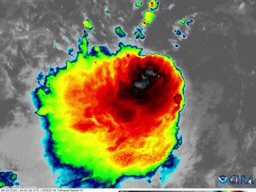
Ensembles follow the GFS to the east.
I also think that's a pretty reasonable spread from the GEFS tonight.

HWRF is getting into range, especially in the short range. It ends up going over just the tip of Cuba and is running NE in the last frame.

European remains the eastern most of the deterministic models tonight. That is back west some from 18z.
Euro ensembles aren't out.
For all the wild swings of the past day or so, we're starting to get some agreement on the west coast of Florida.
Posted on 9/23/22 at 1:41 am to HeyCap
quote:
This one, by your own account, seems to be a dick swinging contest
And considering you’re a gigantic pussy you should just move on
This post was edited on 9/23/22 at 2:18 am
Posted on 9/23/22 at 3:12 am to kc8876
When are the next set of update?

 Page 100 of 465

Popular
Back to top