- My Forums
- Tiger Rant
- LSU Recruiting
- SEC Rant
- Saints Talk
- Pelicans Talk
- More Sports Board
- Fantasy Sports
- Golf Board
- Soccer Board
- O-T Lounge
- Tech Board
- Home/Garden Board
- Outdoor Board
- Health/Fitness Board
- Movie/TV Board
- Book Board
- Music Board
- Political Talk
- Money Talk
- Fark Board
- Gaming Board
- Travel Board
- Food/Drink Board
- Ticket Exchange
- TD Help Board
Customize My Forums- View All Forums
- Show Left Links
- Topic Sort Options
- Trending Topics
- Recent Topics
- Active Topics
Started By
Message

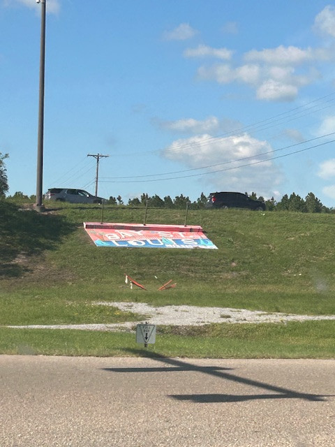
Hurricane Spinoff: Bay St Louis high-water mark from Katrina w/pics
Posted on 9/26/24 at 4:52 pm

Posted on 9/26/24 at 4:52 pm
Part of the Helene convo last night centered around the high-water marker that was built on the side of I-10 where 603 intersects. It no longer says Katrina high water mark due to the negative image it gives along with some bad memories for those who were there. Here's what it looks like today:
 6
6


Posted on 9/26/24 at 4:54 pm to MondayMorningMarch
You never see a low water mark but they’re out there.
Posted on 9/26/24 at 4:57 pm to OysterPoBoy
This is about 5 miles inland.
Posted on 9/26/24 at 5:03 pm to MondayMorningMarch
quote:
It no longer says Katrina high water mark due to the negative image it gives along with some bad memories for those who were there

Posted on 9/26/24 at 5:32 pm to MondayMorningMarch
Not really. It is inland but you have the Jourdan River and bay right by the interstate there. It is near the bridge that crosses into Diamondhead.
It would be no different than saying we had that much water on Grand Isle and Golden Meadow.
The difference between coastal Louisiana and Mississippi is elevation.
In Pass Christian, there are houses that are on the beach that sit on a hill or bluff as much as 10-20 feet up compared to the beach. I know there are places that are lower behind this bluff.
On Grand Isle and in Golden Meadow there is no elevation except for the Levees.
Posted on 9/26/24 at 5:35 pm to MondayMorningMarch
quote:
This is about 5 miles inland.
I believe it was 25 feet where this pic was taken and 41.5 feet in Waveland.
Posted on 9/26/24 at 5:57 pm to MrLSU
According to google earth, the sign is at about 25 feet.
Now one thing was if that was a debris line or the actual level. Sometimes debris can go higher due to wave and wind action.
Heck during Ida, I saw some Facebook videos of some serious waves in Bayou Lafourche and the Intracoastal in Larose.
Now one thing was if that was a debris line or the actual level. Sometimes debris can go higher due to wave and wind action.
Heck during Ida, I saw some Facebook videos of some serious waves in Bayou Lafourche and the Intracoastal in Larose.

Posted on 9/26/24 at 6:04 pm to OysterPoBoy

Posted on 10/9/24 at 7:39 am to MrLSU
quote:
I believe it was 25 feet where this pic was taken and 41.5 feet in Waveland.
And it wasn’t just the height of the water…. shite rolled in like a tsunami. Wall of water. That’s mainly why it looked like a nuke went off. The shallow water off the coast let it build up
Posted on 10/9/24 at 7:45 am to MondayMorningMarch
I lived in Jourdan river shores about 3 miles north of this and I had 16 feet of water above my slab at my house. which was 20 plus storm surge 8 miles from the gulf
This post was edited on 10/9/24 at 7:46 am
Posted on 10/9/24 at 8:13 am to Robcrzy
My dad’s house in Jourdan River Shores was built 23 ft. above normal river level and he still got a foot or two of water in it.
Posted on 10/9/24 at 8:53 am to Robcrzy
My dad lives in BSL about a mile behind railroad tracks. Got water over the roof.
I know Jourdan River very well. He’d take us to ride jet skis over there a lot
I know Jourdan River very well. He’d take us to ride jet skis over there a lot
Posted on 10/9/24 at 9:27 am to MondayMorningMarch
A friend of mine lived in S. Diamondhead. I went over to help him look for anything left from his place as well as his boat. We found the boat about 200 yds in the woods north of the neighborhood. It was basically hanging bow up between a couple pine trees. There was an 50ft Hatteras sitting about 25yds away. About 20ft from ground level, a 5-10ft section of bark on the pine trees was missing. The debris shifting back & forth through there with the massive wave action had rubbed it all off. Not a single house left standing. Just rubble. Looked like a nuke went off. Had to be a horrible scene while that was going on.

Posted on 10/9/24 at 9:36 am to MondayMorningMarch
My camp is Shoreline Park, BSL,MS
I’d been thru several hurricanes before and foolishly thought I had a good plan.
Aside from securing stuff I hurried and mowed the lawn because it may be muddy for weeks. Kat kicked my arse, I had grass trimmings in the attic. I know this because the ceilings fell from flood water. I was at 13.5 above sea level and completely submerged.
Camp was saved and raised to 20’ and built above minimum standards.
Posted on 10/9/24 at 9:39 am to MondayMorningMarch
quote:
It no longer says Katrina high water mark due to the negative image it gives along with some bad memories for those who were there.
Gotta worry about those feelings.
Posted on 10/9/24 at 3:44 pm to TigrrrDad
quote:
My dad’s house in Jourdan River Shores was built 23 ft. above normal river level and he still got a foot or two of water in it.
sounds about right slab was about about 6-7 above normal water level

 Page 1 of 1


Popular
Back to top