- My Forums
- Tiger Rant
- LSU Recruiting
- SEC Rant
- Saints Talk
- Pelicans Talk
- More Sports Board
- Fantasy Sports
- Golf Board
- Soccer Board
- O-T Lounge
- Tech Board
- Home/Garden Board
- Outdoor Board
- Health/Fitness Board
- Movie/TV Board
- Book Board
- Music Board
- Political Talk
- Money Talk
- Fark Board
- Gaming Board
- Travel Board
- Food/Drink Board
- Ticket Exchange
- TD Help Board
Customize My Forums- View All Forums
- Show Left Links
- Topic Sort Options
- Trending Topics
- Recent Topics
- Active Topics
Started By
Message

 0
0

Posted on 10/5/17 at 4:49 pm to Hammertime
quote:
I suggested to the guys at Radarscope that they integrate offshore bouy data into their app. That was when Harvey was out by the islands. They said they were gonna get on it
They need to find a way for Radarscope to run on my MacBook Pro without crashing when I click on any storm warning. It's infuriating and happens every single time. Wasn't a problem when I originally bought the app though.
Posted on 10/5/17 at 4:50 pm to slackster
Don't like the GFS runs. It would probably carve us up over here when it makes that turn.
Posted on 10/5/17 at 4:51 pm to slackster
GFS still on the west side of guidance.
Weaker would be cool too.
Weaker would be cool too.
Posted on 10/5/17 at 4:51 pm to Duke
quote:
Currently not liking the progression of that ULL rolling SW in the Bay of Campeche. That sets up far enough SW and it'll start to pull some shear off Nate tonight into tomorrow and act to ventilate Nate as he rolls up the gulf.
That's certainly not the only factor at play, but worth keeping an eye on.
Been watching that for a few days now, it was always going to be kind of a razors edge type thing. It will either linger longer and keep Nate under shear or it will rotate out in time to aid outflow. We'll know which one it is in the next 24hrs but it really seems to be moving out of the way pretty fast this evening.
Posted on 10/5/17 at 4:53 pm to rds dc
Do the models take into account gunfire from Mexico?
Posted on 10/5/17 at 4:53 pm to Duke
quote:
GFS still on the west side of guidance.
Yeah, the 12z operation run was to the west of most of the ensemble members, so perhaps the 18z is coming back in line some. We'll see. Hard to imagine we're only 54 hours or so away from a TS/hurricane landfall and yet we don't know much.
Posted on 10/5/17 at 4:54 pm to rds dc
12z all model landfall probability
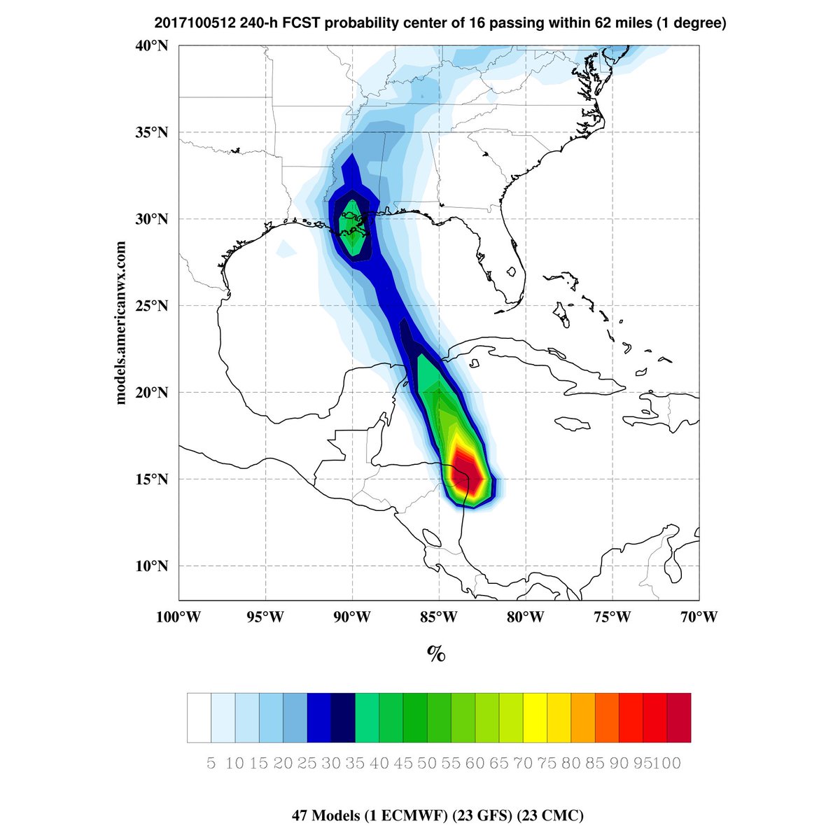
All tracks

All tracks
This post was edited on 10/5/17 at 4:56 pm
Posted on 10/5/17 at 4:56 pm to rds dc
quote:
Been watching that for a few days now, it was always going to be kind of a razors edge type thing. It will either linger longer and keep Nate under shear or it will rotate out in time to aid outflow. We'll know which one it is in the next 24hrs but it really seems to be moving out of the way pretty fast this evening.
Best I can tell, the GFS gets that ULL out of the way, but still keeps Nate above 990mb through the GOM.


Posted on 10/5/17 at 4:58 pm to rds dc
This looks like ground zero is Mobile.
Like I had previously said.
Like I had previously said.

Posted on 10/5/17 at 4:59 pm to rds dc
That red line on the west side of all the tracks next to the "66" would be tough on Baton Rouge.
Posted on 10/5/17 at 5:06 pm to rds dc
It's crazy at how abrupt the turn happens when it hits Louisiana in the models. Considering the speed of the system whether it slows down or speeds up and the models are off by about 12 hours on landfall it could really change the track.
Posted on 10/5/17 at 5:08 pm to slackster
They replied to me within hours of my email. Might be worth a shot
Posted on 10/5/17 at 5:09 pm to Wild Thang
quote:
This looks like ground zero is Mobile.
Like I had previously said.
Well played.

Posted on 10/5/17 at 5:10 pm to Duke
What can we do to keep duke vvvvvvvv out of this thread?
Posted on 10/5/17 at 5:12 pm to Duke
quote:
Well played.
Thank you. I thought it was a nice way to make fun of myself.
frick the track of this storm though.

Posted on 10/5/17 at 5:18 pm to USEyourCURDS
quote:
What can we do to keep duke vvvvvvvv out of this thread?
He's already been in this thread and the damage done.
Posted on 10/5/17 at 5:21 pm to slackster
quote:
Best I can tell, the GFS gets that ULL out of the way, but still keeps Nate above 990mb through the GOM.
I think there are two things that are keeping Nate in check on both the GFS and Euro right up until landfall. Both models show a quick burst of strengthening right before landfall but basically keep it in check on the trek across the Gulf.
As of tonight, Nate has not been able to consolidate and separate from the larger circulation across CA. This kind of sloppy setup is further enhanced as it interacts with the wave moving out across the Gulf from Florida. The second thing is some dry air.
It looked like Nate might avoid the dry air as the Florida wave swung out across the Gulf but the models are showing a streamer of dry air that hangs back as the main area of dry air pushes west.

As Nate tries to consolidate over the Gulf this dry air looks to get wrapped into the circulation.

So the combo of dry air and Nate being embedded in a larger circulation keeps things in check.

Nate would need to tighten up a lot overnight and into tomorrow to avoid the dry air and to pull away from the larger circulation.
Posted on 10/5/17 at 5:21 pm to Duke
quote:
Currently not liking the progression of that ULL rolling SW in the Bay of Campeche. That sets up far enough SW and it'll start to pull some shear off Nate tonight into tomorrow and act to ventilate Nate as he rolls up the gulf.
Can you explain this like I'm 5 in what it relates to what will happen in Kenner?

Posted on 10/5/17 at 5:25 pm to TigerstuckinMS
quote:I missed it, what did he predict?
He's already been in this thread and the damage done.

 Page 57 of 193

Popular
Back to top