- My Forums
- Tiger Rant
- LSU Recruiting
- SEC Rant
- Saints Talk
- Pelicans Talk
- More Sports Board
- Fantasy Sports
- Golf Board
- Soccer Board
- O-T Lounge
- Tech Board
- Home/Garden Board
- Outdoor Board
- Health/Fitness Board
- Movie/TV Board
- Book Board
- Music Board
- Political Talk
- Money Talk
- Fark Board
- Gaming Board
- Travel Board
- Food/Drink Board
- Ticket Exchange
- TD Help Board
Customize My Forums- View All Forums
- Show Left Links
- Topic Sort Options
- Trending Topics
- Recent Topics
- Active Topics
Started By
Message
 1
1

Posted on 10/6/24 at 11:35 pm to DVinBR
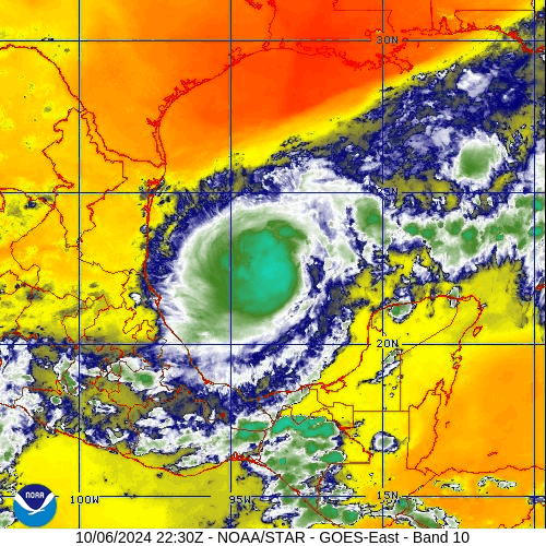
You can really see on water vapor.
This post was edited on 10/6/24 at 11:38 pm
Posted on 10/6/24 at 11:47 pm to TutHillTiger
She is a pis_ poor jurist…and I’m being kind.

Posted on 10/7/24 at 12:18 am to LegendInMyMind

Posted on 10/7/24 at 12:30 am to BigBrod81
That don't look good
Hunker down, Tampa
Hunker down, Tampa

Posted on 10/7/24 at 1:10 am to ell_13
quote:
Starting to think Jacksonville isn’t the best place to be either.
I am about 30 mins south of jacksonville and the main thing that will happen here will be the backwash of the st. John's river and the hurricane causing flooding along the coast of St.Augustine and area beaches that are prone to flooding when these events happen. We definitely avoided the big bullet with the last hurricane but won't be that lucky this time I expect alot of rain and flooding on this side of Florida.
Posted on 10/7/24 at 1:15 am to frankthetank
quote:
I'm currently with family in disney till Friday. Wondering if we should call the vacation early and head out tomorrow sometime. Staying in Disney so maybe we'll be OK if we stay?
I would leave this area. I do believe the last hurricane (I think it was Irma) that cut across the state like this caused severe flooding all across Orlando. If I had family I will get the hell out of there before you get stuck.
ETA: It was Hurricane IAN in 2022
This post was edited on 10/7/24 at 4:40 am
Posted on 10/7/24 at 3:37 am to FLBooGoTigs1
quote:
I do believe the last hurricane (I think it was Irma)
Nope. Irma came in down by San Marcos island and chugged up the state. It crossed I-4 at Plant City, 40-45 miles from Disney, and a little more than 50 miles from Orlando. The 11 pm update puts the eye track 35-ish miles from Disney.
Posted on 10/7/24 at 3:43 am to Hangit
which one caused the flooding in Orlando recently then?
ETA: Just found something was it Hurricane Ian in 2022?
ETA: Just found something was it Hurricane Ian in 2022?
This post was edited on 10/7/24 at 3:45 am
Posted on 10/7/24 at 4:07 am to FLBooGoTigs1

Looks like its hitting a bit later than the previous track stated and looks like cone is shrinking alittle more each time.
Posted on 10/7/24 at 4:27 am to FLBooGoTigs1
quote:
Just found something was it Hurricane Ian in 2022?
Ian was bad. Flooding left thousands homeless around southern Polk County, flooded Olando, then went and washed the beach out from under a bunch of beach houses south of Daytona.
This is all in addition to what it did in SW Florida.
Posted on 10/7/24 at 4:47 am to Hangit
HAZARDS AFFECTING LAND
----------------------
Key Messages for Hurricane Milton can be found in the Tropical
Cyclone Discussion under AWIPS header MIATCDAT4 and WMO header
WTNT44 KNHC and on the web at hurricanes.gov/text/MIATCDAT4.shtml
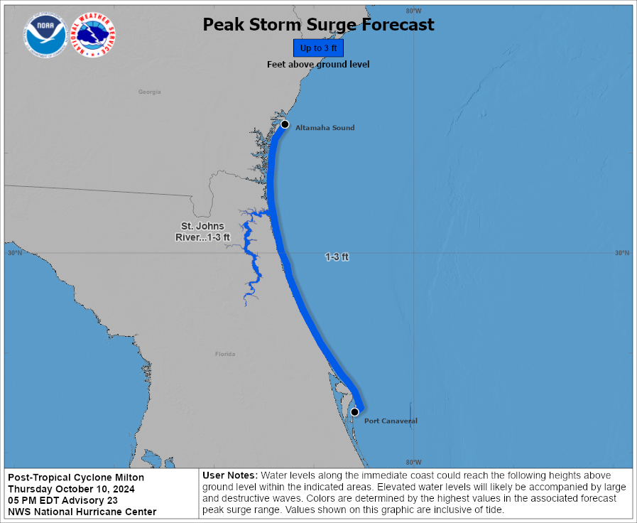
STORM SURGE: A storm surge will raise water levels by as much as 2
to 4 feet above ground level along the northern coast of the
Yucatan Peninsula in areas of onshore winds. Near the coast, the
surge will be accompanied by large and destructive waves.
The combination of a dangerous storm surge and the tide will cause
normally dry areas near the coast to be flooded by rising waters
moving inland from the shoreline. The water could reach the
following heights above ground somewhere in the indicated areas if
the peak surge occurs at the time of high tide...
Anclote River, FL to Englewood, FL...8-12 ft
Tampa Bay...8-12 ft
Yankeetown, FL to Anclote River, FL...5-10 ft
Englewood, FL to Bonita Beach, FL...5-10 ft
Charlotte Harbor...5-10 ft
Bonita Beach, FL to Chokoloskee, FL...4-7 ft
Suwannee River, FL to Yankeetown, FL...3-5 ft
----------------------
Key Messages for Hurricane Milton can be found in the Tropical
Cyclone Discussion under AWIPS header MIATCDAT4 and WMO header
WTNT44 KNHC and on the web at hurricanes.gov/text/MIATCDAT4.shtml
STORM SURGE: A storm surge will raise water levels by as much as 2
to 4 feet above ground level along the northern coast of the
Yucatan Peninsula in areas of onshore winds. Near the coast, the
surge will be accompanied by large and destructive waves.
The combination of a dangerous storm surge and the tide will cause
normally dry areas near the coast to be flooded by rising waters
moving inland from the shoreline. The water could reach the
following heights above ground somewhere in the indicated areas if
the peak surge occurs at the time of high tide...
Anclote River, FL to Englewood, FL...8-12 ft
Tampa Bay...8-12 ft
Yankeetown, FL to Anclote River, FL...5-10 ft
Englewood, FL to Bonita Beach, FL...5-10 ft
Charlotte Harbor...5-10 ft
Bonita Beach, FL to Chokoloskee, FL...4-7 ft
Suwannee River, FL to Yankeetown, FL...3-5 ft
Posted on 10/7/24 at 5:34 am to lsuman25
Damn got to be confirmed but recon is finding pressures in the low 950's now

Posted on 10/7/24 at 5:42 am to lsuman25
Follow guidance from your local city and county officials on evacuation. I know it’s a tough decision to leave - believe me, I’ve been there many times.
If evacuation is only recommended and you have any doubt in your mind, just leave. The aftermath is almost always worse than the storm itself.
Several feet of surge plus waves on top of that is not something to take a chance on.
Good luck and I hope minimal impact to those of you in Florida.
If evacuation is only recommended and you have any doubt in your mind, just leave. The aftermath is almost always worse than the storm itself.
Several feet of surge plus waves on top of that is not something to take a chance on.
Good luck and I hope minimal impact to those of you in Florida.
Posted on 10/7/24 at 5:50 am to LegendInMyMind
Is it the remnants of the one on the west coast of Mex a few weeks ago reforming up? I had bad vibes on that thing kickin our arse after Francine took pity on us
Posted on 10/7/24 at 5:52 am to lsuman25
quote:
Damn got to be confirmed but recon is finding pressures in the low 950's now
That would be ahead of schedule, correct?
Posted on 10/7/24 at 5:55 am to GEAUXT
955 offically. Yes ahead of schedule
Posted on 10/7/24 at 6:01 am to lsuman25
.NOAA HURRICANE HUNTERS FIND MILTON A MAJOR HURRICANE...
6:00 AM CDT Mon Oct 7
Location: 21.9°N 92.4°W
Moving: ESE at 8 mph
Min pressure: 954 mb
Max sustained: 120 mph
6:00 AM CDT Mon Oct 7
Location: 21.9°N 92.4°W
Moving: ESE at 8 mph
Min pressure: 954 mb
Max sustained: 120 mph

Posted on 10/7/24 at 6:03 am to rds dc
Hurricane Milton Tropical Cyclone Update
NWS National Hurricane Center Miami FL AL142024
600 AM CDT Mon Oct 07 2024
...NOAA HURRICANE HUNTERS FIND MILTON A MAJOR HURRICANE...
Data from a NOAA Hurricane Hunter aicraft indicate that Milton has
strengthened to a major hurricane. The maximum sustained winds are
estimated to be 120 mph (195 km/h). Milton is a category three
hurricane on the Saffir-Simpson Hurricane Wind Scale. Data from
the aircraft also indicate that the minimum pressure has fallen to
954 mb (28.17 inches).
A special advisory will be issued by 7 AM CDT (1200 UTC) to reflect
this change and update the forecast.
SUMMARY OF 600 AM CDT...1100 UTC...INFORMATION
----------------------------------------------
LOCATION...21.9N 92.4W
ABOUT 180 MI...285 KM WNW OF PROGRESO MEXICO
ABOUT 750 MI...1210 KM WSW OF TAMPA FLORIDA
MAXIMUM SUSTAINED WINDS...120 MPH...195 KM/H
PRESENT MOVEMENT...ESE OR 105 DEGREES AT 8 MPH...13 KM/H
MINIMUM CENTRAL PRESSURE...954 MB...28.17 INCHES

 Page 46 of 242

Popular
Back to top