- My Forums
- Tiger Rant
- LSU Recruiting
- SEC Rant
- Saints Talk
- Pelicans Talk
- More Sports Board
- Fantasy Sports
- Golf Board
- Soccer Board
- O-T Lounge
- Tech Board
- Home/Garden Board
- Outdoor Board
- Health/Fitness Board
- Movie/TV Board
- Book Board
- Music Board
- Political Talk
- Money Talk
- Fark Board
- Gaming Board
- Travel Board
- Food/Drink Board
- Ticket Exchange
- TD Help Board
Customize My Forums- View All Forums
- Show Left Links
- Topic Sort Options
- Trending Topics
- Recent Topics
- Active Topics
Started By
Message
 3
3

Posted on 10/6/24 at 9:12 am to Hangit
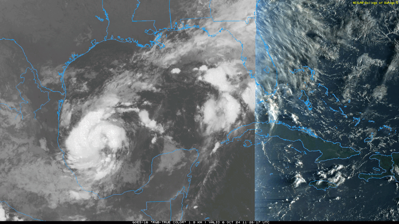
Posting about the second storm is irresponsible
Remember last week this storm was headed to La
Remember last week this storm was headed to La

Posted on 10/6/24 at 9:13 am to LanierSpots
This is just worst case scenario for this area predicted to be hit again. Tampa/ St.pete areas are already fricked by Helene if they take a direct hit with 15 ft or higher storm surge it's turn the lights out the party's over there. Its been close to a one hundred fifty years since a storm has taken this same storm track starting from the Mexican coast and heading east across the gulf into this area of Florida. Prayers again to this area
Posted on 10/6/24 at 9:25 am to deltaland
Dangerous situation unfolding across the Gulf. This will be a tough call for the Tampa area. Stronger system might miss them to the north (which will still be bad for Tampa), and a weaker system might slide south.

Posted on 10/6/24 at 9:37 am to rds dc
If it goes slower, does it churn up the cooler waters which can work to weaken it? That was discussed last week, is that still in play?
Posted on 10/6/24 at 9:45 am to Suntiger
quote:
If it goes slower, does it churn up the cooler waters which can work to weaken it? That was discussed last week, is that still in play?
That would only come into play if the system was stationary for a period of time. It will be moving plenty quick over very warm waters.

Posted on 10/6/24 at 9:54 am to Hangit
quote:
Go now and fill your vehicles and gas cans.
Yuppers, did that yesterday as well as the liquor and grocery store run for extra supplies. Husband's firing up the generator today to make sure that's hopefully still good to roll.
Then bring the lawn projectiles into the garage Tuesday and play the waiting game.
Be safe.
Posted on 10/6/24 at 10:04 am to rds dc
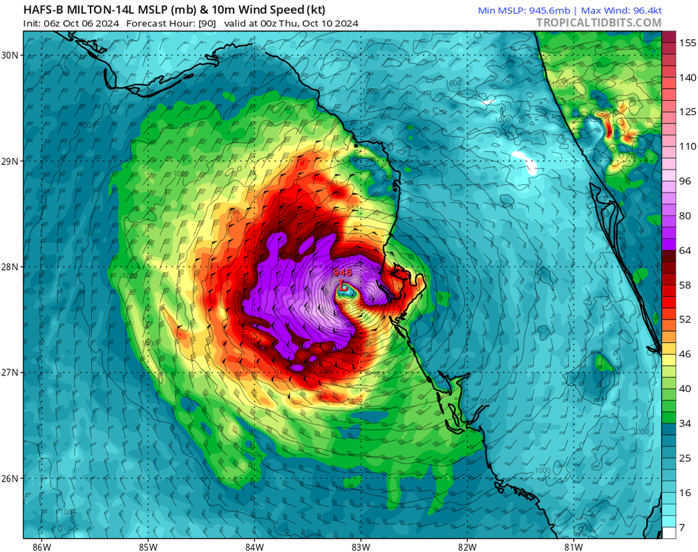
HAFS B seems to be handling things best this morning, and it might even be too slow with organization. It does weaken the system to the 940s before landfall.

Posted on 10/6/24 at 10:06 am to rds dc
quote:
Dangerous situation unfolding across the Gulf. This will be a tough call for the Tampa area.
And another one next week.

Posted on 10/6/24 at 10:12 am to Hangit
Posted on 10/6/24 at 10:12 am to loogaroo
quote:
And another one next week.
Too early, but the pattern remains supportive.
Posted on 10/6/24 at 10:16 am to deltaland
quote:
If this thing does make it to a Cat 5 is the expectation of it rapidly weakening by 60 mb reasonable?
Small core.
The weakening mechanism at landfall is dry air getting worked into the center. Rapid weakening would be the result if a big slug of the dry stuff gets worked into that core.
Posted on 10/6/24 at 10:18 am to CarolinaGamecock99
is it me or is this cone wider than normal cones w only 3 days out?
this thing covers the nearly the entire state of florida
this thing covers the nearly the entire state of florida

Posted on 10/6/24 at 10:21 am to rds dc
I've got a flight Wednesday afternoon out of MSY direct to MCO. Southwest dragging arse on canceling it because there's no way that flight is happening now.

Posted on 10/6/24 at 10:24 am to rds dc
quote:
Tropical Storm Milton
My middle name is Milton. I hate that name.
Posted on 10/6/24 at 10:24 am to BilbeauTBaggins
My 7:30pm flight isn’t canceled yet either.
Posted on 10/6/24 at 10:28 am to rocket31
The cone is the same width its been all season.

Posted on 10/6/24 at 10:29 am to aTmTexas Dillo
quote:
My middle name is Milton. I hate that name.


Posted on 10/6/24 at 10:32 am to rds dc
Well that sucks

Posted on 10/6/24 at 10:35 am to aTmTexas Dillo

 Page 34 of 242

Popular
Back to top