- My Forums
- Tiger Rant
- LSU Recruiting
- SEC Rant
- Saints Talk
- Pelicans Talk
- More Sports Board
- Fantasy Sports
- Golf Board
- Soccer Board
- O-T Lounge
- Tech Board
- Home/Garden Board
- Outdoor Board
- Health/Fitness Board
- Movie/TV Board
- Book Board
- Music Board
- Political Talk
- Money Talk
- Fark Board
- Gaming Board
- Travel Board
- Food/Drink Board
- Ticket Exchange
- TD Help Board
Customize My Forums- View All Forums
- Show Left Links
- Topic Sort Options
- Trending Topics
- Recent Topics
- Active Topics
Started By
Message
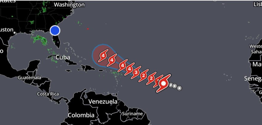
re: Hurricane Lee Forecast to be 150MPH+
Posted on 9/6/23 at 10:24 am to tide06
Posted on 9/6/23 at 10:24 am to tide06
Speaking of Idalia, what in the hell happened to that coverage? Talk about drive-by media. All we kept hearing was "supersized", "waters warmer than ever", "Human-made climate change", now not a peep......
 2
2


Posted on 9/6/23 at 10:31 am to GumboPot
quote:
a high pressure cock
That doesn't sound good.
Posted on 9/6/23 at 10:40 am to SlickRick55
quote:
Speaking of Idalia, what in the hell happened to that coverage? Talk about drive-by media. All we kept hearing was "supersized", "waters warmer than ever", "Human-made climate change", now not a peep......
Idalia behaved like a normal hurricane. When it hit the hit GOM waters it did just what hurricanes are supposed to do in that environment. The fearmongers didn’t like that and the poor folks who are suffering as a result get shortchanged.

Posted on 9/6/23 at 10:41 am to doubleb
quote:
Idalia behaved like a normal hurricane. When it hit the hit GOM waters it did just what hurricanes are supposed to do in that environment. The fearmongers didn’t like that and the poor folks who are suffering as a result get shortchanged.
That, and the fact that it made landfall and went inland at about the only spot in Florida that is basically not populated at all.

Posted on 9/6/23 at 10:44 am to Bigfishchoupique
quote:
When will y’all start to get a good swell ?
going to start around monday and last through the week
Posted on 9/6/23 at 10:46 am to ChestRockwell
quote:
Hits NOLA. Revenge for taking down his statue.

Posted on 9/6/23 at 10:56 am to Y.A. Tittle
quote:
That, and the fact that it made landfall and went inland at about the only spot in Florida that is basically not populated at all.
All true, but don’t tell that to all those folks who hit hit really hard. I bet they don’t want to hear it.
Posted on 9/6/23 at 11:26 am to ChestRockwell
quote:
Hits NOLA. Revenge for taking down his statue.
A Lee already came to south Louisiana in 2011 as a Tropical Storm.
Mitch took Lee down his perch in 2017.
Posted on 9/6/23 at 11:37 am to SlickRick55
quote:
Speaking of Idalia, what in the hell happened to that coverage? Talk about drive-by media. All we kept hearing was "supersized", "waters warmer than ever", "Human-made climate change", now not a peep......
Three things I'll say until they throw me in a hole:
1. Smithville, MS was the strongest tornado on April 27, 2011 by a fair margin.
2. Mayfield, KY was an EF5.
3. Hurricane Idalia was not a major hurricane at landfall.
When the highest sustained wind and gust recorded comes from Jeff Piotrowski, you have a problem.

Posted on 9/6/23 at 11:38 am to Y.A. Tittle
quote:
That, and the fact that it made landfall and went inland at about the only spot in Florida that is basically not populated at all.
It also weakened considerably before landfall and wasn’t all that bad all things considered.
Posted on 9/6/23 at 11:45 am to LegendInMyMind
Def wasn’t no IDA!!!!
Posted on 9/6/23 at 11:49 am to LegendInMyMind
Hurricane Jova in the East Pacific is incredible. Even better there’s going to be nothing but a water in front of it so it’s ok to enjoy it.
It’s in a perfect environment and has exploded. The outflow has been incredible. Lee will turn into a beast but Jova has it beat right now.
It’s in a perfect environment and has exploded. The outflow has been incredible. Lee will turn into a beast but Jova has it beat right now.
Posted on 9/6/23 at 11:55 am to The Boat
Watching it come together and seeing that eye peek out is quality satelliting.
Posted on 9/6/23 at 12:27 pm to McGruff21
Always get a little nervous when you kinda in the crosshairs until you actually see the turn north.
Posted on 9/6/23 at 12:31 pm to FLObserver
we just need this heat dome to hover for about another month and a half over Texas and LA
Posted on 9/6/23 at 12:31 pm to FLObserver

Look at that circulation at the center and it isn't even a hurricane yet. Lee going to be a beast going up the East coast.

Posted on 9/6/23 at 12:42 pm to The Boat
Jova looks like a WPac storm with that pinpoint eye and yuge outflow
Posted on 9/6/23 at 1:46 pm to McGruff21
Will Baton Rouge lose power?
Should I cancel my trip to Grand Isle?
Should I cancel my trip to Grand Isle?
Posted on 9/6/23 at 1:47 pm to McGruff21
What happened to the J and K storms?
Posted on 9/6/23 at 1:50 pm to Bestbank Tiger
José and Katia were quick Tropical storms that moved east of Bermuda after Idalia

 Page 3 of 18

Popular
Back to top