- My Forums
- Tiger Rant
- LSU Recruiting
- SEC Rant
- Saints Talk
- Pelicans Talk
- More Sports Board
- Fantasy Sports
- Golf Board
- Soccer Board
- O-T Lounge
- Tech Board
- Home/Garden Board
- Outdoor Board
- Health/Fitness Board
- Movie/TV Board
- Book Board
- Music Board
- Political Talk
- Money Talk
- Fark Board
- Gaming Board
- Travel Board
- Food/Drink Board
- Ticket Exchange
- TD Help Board
Customize My Forums- View All Forums
- Show Left Links
- Topic Sort Options
- Trending Topics
- Recent Topics
- Active Topics
Started By
Message
re: Hurricane Irma - Spinning Down
Posted on 9/4/17 at 12:15 pm to tankyank13

Posted on 9/4/17 at 12:15 pm to tankyank13
quote:
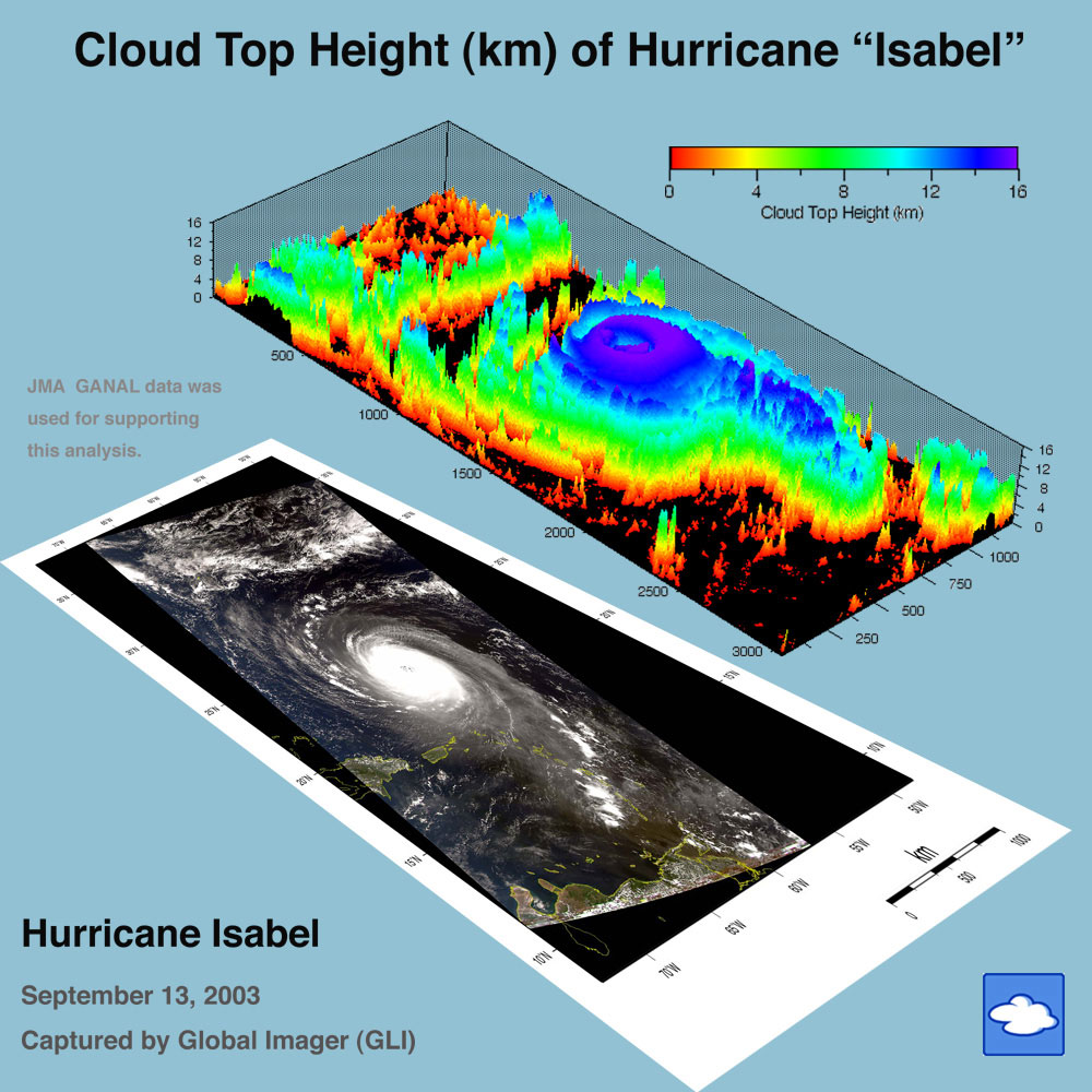
Question for the experts. How tall are the cloud tops on a cat 5 hurricane? Just curious
 1
1


Posted on 9/4/17 at 12:16 pm to phil good
quote:It will be interesting to see if any of them book reservations in the 'Hurricane Resistant Hurricane Safe and SoundProof' Hotel in Miami.
I bet Jeff and crew are eastbound and down. This is going to be an intense periscope broadcast whenever and wherever this thing makes landfall.
Miami FL Hotel: Hurricane Safe and SoundProof
LINK
Posted on 9/4/17 at 12:16 pm to St Augustine
quote:
Man every store in palm beach county sold out of water and plywood already lol. Wonder if Ill get the house I'm supposed to close on next month for cheaper if it doesn't have a roof.
Rent in meantime, it's going to be a buyers market. Take advantage of it.

Posted on 9/4/17 at 12:17 pm to St Augustine
quote:I had a house on the east side of A1A in Ocean Ridge, 1 block off the ocean. If it grinds up the east coast of Florida like that, I don't expect that house will survive. Miss the area, but don't miss these storms.
Man every store in palm beach county sold out of water and plywood already lol. Wonder if Ill get the house I'm supposed to close on next month for cheaper if it doesn't have a roof.
Posted on 9/4/17 at 12:17 pm to Rakim
Already own here but cheap. Was looking forward to selling mine high 

Posted on 9/4/17 at 12:19 pm to HubbaBubba
If Irma were to take the GFS path, the number of people who will have to evacuate will be historic. With the way it just goes over much of the peninsula of FL the devastation would be widespread.
Again, that's all if things panned out like the GFS shows.
Again, that's all if things panned out like the GFS shows.
This post was edited on 9/4/17 at 12:19 pm
Posted on 9/4/17 at 12:20 pm to tankyank13
quote:
Question for the experts. How tall are the cloud tops on a cat 5 hurricane? Just curious
Isabel near peak intensity:
Posted on 9/4/17 at 12:21 pm to HubbaBubba
quote:
Doubtful it's that high, but certainly gusts of 165 -175 wouldn't be a surprise.
I may be exaggerating but with a central pressure that low there is no way it doesn't reach Category 5 strength before landfall. If those predictions hold I'm sticking with my gut and saying this thing becomes the first Atlantic hurricane to make landfall as a five since Andrew in '92.
Posted on 9/4/17 at 12:22 pm to Duke
Subject: E14)What have been the most intense hurricanes to strike the United States?
Contributed by Chris Landsea (NHC)
The most intense mainland United States hurricanes by central pressure 1851-2015
RANK HURRICANE YEAR CATEGORY(at landfall) MINIMUM PRESSURE Millibars Inches
1 FL (Keys) 1935 5 892 26.35
2 CAMILLE (MS/SE LA/VA) 1969 5 900 26.58
3 KATRINA (LA) 2005 3 920 27.17
4 ANDREW (SE FL/SE LA) 1992 5 922 27.23
5 TX (Indianola) 1886 4 925 27.31
6 FL (Keys)/S TX 1919 4 927 27.37
7 FL (Lake Okeechobee) 1928 4 929 27.43
8 DONNA (FL/Eastern U.S.) 1960 4 930 27.46
9 LA (New Orleans) 1915 4 931 27.49
9 CARLA (N & Central TX) 1961 4 931 27.49
11 LA (Last Island) 1856 4 934 27.58
12 HUGO (SC) 1989 4 934 27.58
13 FL (Miami)/MS/AL/Pensacola 1926 4 935 27.61
14 TX (Galveston) 1900 4 936 27.64
15 RITA (NE TX,W LA) 2005 3 937 27.67
ETA HARVEY (TX) 2017 4 938 27.70
16 GA/FL (Brunswick) 1898 4 938 27.70
17 HAZEL (SC/NC) 1954 4 938 27.70
18 SE FL/SE LA/MS 1947 4 940 27.76
19 N TX 1932 4 941 27.79
19 CHARLEY (SW FL) 2004 4 941 27.79
21 GLORIA (Eastern U.S.) 1985 3& 942 27.82
21 OPAL (NW FL/AL) 1995 3& 942 27.82
-- SANDY (NJ/NY/CN) 2012 1% 942 27.82
23 FL (Central) 1888 3 945 27.91
23 E NC 1899 3 945 27.91
23 AUDREY (SW LA/N TX) 1957 4# 945 27.91
23 TX (Galveston) 1915 4# 945 27.91
23 CELIA (S TX) 1970 3 945 27.91
23 ALLEN (S TX) 1980 3 945 27.91
29 New England 1938 3 946 27.94
29 FREDERIC (AL/MS) 1979 3 946 27.94
29 IVAN (AL, NW FL) 2004 3 946 27.94
29 DENNIS (NW FL) 2005 3 946 27.94
33 NE U.S. 1944 3 947 27.97
33 SC/NC 1906 3 947 27.97
35 LA (Chenier Caminanda) 1893 3 948 27.99
35 BETSY (SE FL/SE LA) 1965 3 948 27.99
35 SE FL/NW FL 1929 3 948 27.99
35 SE FL 1933 3 948 27.99
35 S TX 1916 3 948 27.99
35 MS/AL 1916 3 948 27.99
41 NW FL 1882 3 949 28.02
41 DIANA (NC) 1984 3+ 949 28.02
41 S TX 1933 3 949 28.02
44 WILMA (SW FL) 2005 3 950 28.05
44 GA/SC 1854 3 950 28.05
44 LA/MS 1855 3 950 28.05
44 LA/MS/AL 1860 3 950 28.05
44 LA 1879 3 950 28.05
44 BEULAH (S TX) 1967 3 950 28.05
44 HILDA (Central LA) 1964 3 950 28.05
44 GRACIE (SC) 1959 3 950 28.05
44 TX (Central) 1942 3 950 28.05
44 JEANNE (FL) 2004 3 950 28.05
44 IKE (TX/LA) 2008 2 950 28.05
This post was edited on 9/4/17 at 12:34 pm
Posted on 9/4/17 at 12:24 pm to RollTide1987
quote:I drove through there in '94. Was surreal. Everything just completely flattened.
Andrew in '92
Posted on 9/4/17 at 12:26 pm to NorthEndZone
Sandy shouldn't be on this list and certainly not that high, anyway.
Posted on 9/4/17 at 12:27 pm to Roll Tide Ravens
If Irma does impact the US, the resources of the Federal government and all of the humanitarian organizations are going to be spread incredibly thin. Texas Governor Greg Abbot said that he thought Texas would need an additional $125 billion for Harvey relief, if Irma is another extremely destructive hurricane, it is going to be a huge strain.
This post was edited on 9/4/17 at 12:28 pm
Posted on 9/4/17 at 12:27 pm to Roll Tide Ravens
quote:From the Keys up. They would have to turn 95 north both ways (if this is possible I forget) for all to GTFO; like the NC coast has set up for I-40 to go west to GTFO.
If Irma were to take the GFS path, the number of people who will have to evacuate will be historic. With the way it just goes over much of the peninsula of FL the devastation would be widespread.
Again, that's all if things panned out like the GFS shows.
Posted on 9/4/17 at 12:27 pm to Rakim
Odds this makes it into the eastern Gulf are 20-30%.
Posted on 9/4/17 at 12:32 pm to HubbaBubba
when does the ECMWF update next?
Posted on 9/4/17 at 12:34 pm to cajunangelle
will start running in about 15 minutes

Posted on 9/4/17 at 12:34 pm to cajunangelle
12:45 CT

This post was edited on 9/4/17 at 12:39 pm
Posted on 9/4/17 at 12:36 pm to rds dc
GEFS mean is basically the same as 06z, into S. Florida, but the spread is greater.

Posted on 9/4/17 at 12:39 pm to NorthEndZone
So Katrina's pressure was lower than Andrew but it was a cat3 at landfall whereas Andrew was a 5. Are those pressures at landfall as well? Why the decoupling of pressure and windspeed?
Posted on 9/4/17 at 12:41 pm to rds dc
Wow.
I've been out of the loop for a couple days...this thing has really shifted south and west.
Are we looking at a potential gulf threat?
I've been out of the loop for a couple days...this thing has really shifted south and west.
Are we looking at a potential gulf threat?

 Page 77 of 711

Popular
Back to top